Souligné-sous-balloon
| Souligné-sous-balloon | ||
|---|---|---|

|
|
|
| region | Pays de la Loire | |
| Department | Sarthe | |
| Arrondissement | Le Mans | |
| Canton | Bonnétable | |
| Community association | Maine Coeur de Sarthe | |
| Coordinates | 48 ° 8 ' N , 0 ° 14' E | |
| height | 51-103 m | |
| surface | 12.76 km 2 | |
| Residents | 1,202 (January 1, 2017) | |
| Population density | 94 inhabitants / km 2 | |
| Post Code | 72290 | |
| INSEE code | 72340 | |
| Website | http://souligne-sous-ballon.fr/ | |
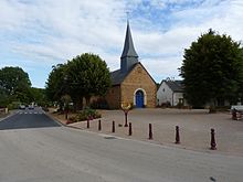
 Town hall (Mairie) of Souligné-sous-Ballon |
||
Souligné-sous-Ballon is a French commune with 1,202 inhabitants (as of January 1 2017) in the department of Sarthe in the region Pays de la Loire . It belongs to the Arrondissement of Le Mans and the Canton of Bonnétable (until 2015: Canton Ballon ). The inhabitants are called Soulignéens .
geography
Souligné-sous-Ballon is located about 14 kilometers north-northeast of Le Mans . Souligné-sous-Ballon is surrounded by the neighboring communities Ballon-Saint Mars in the north and north-east, Courcebœufs in the east, Joué-l'Abbé in the south, La Guierche in the west and south-west and Montbizot in the west and north-west.
Population development
| year | 1962 | 1968 | 1975 | 1982 | 1990 | 1999 | 2006 | 2013 |
| Residents | 869 | 849 | 805 | 847 | 916 | 1.009 | 1,157 | 1,144 |
| Source: Cassini and INSEE | ||||||||
Attractions
- Saint-Martin church, built between 1832 and 1834
- La Freslonnière Castle
- crucifix
literature
- Le Patrimoine des Communes de la Sarthe. Flohic Editions, Volume 1, Paris 2000, ISBN 2-84234-106-6 , pp. 127-130.
Web links
Commons : Souligné-sous-Ballon - Collection of images, videos and audio files

