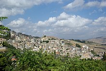
Cammarata
| Cammarata | ||
|---|---|---|

|
|
|
| Country | Italy | |
| region | Sicily | |
| Free community consortium | Agrigento (AG) | |
| Local name | Cammarata | |
| Coordinates | 37 ° 38 ' N , 13 ° 38' E | |
| height | 682 m slm | |
| surface | 191.80 km² | |
| Residents | 6,048 (Dec. 31, 2019) | |
| Population density | 32 inhabitants / km² | |
| Post Code | 92022 | |
| prefix | 0922 | |
| ISTAT number | 084009 | |
| Popular name | Cammaratesi | |
| Patron saint | San Nicola da Bari | |
| Website | Cammarata | |
Cammarata is a town in the municipality of Agrigento consortium outdoors in the region Sicily in Italy .
Location and dates
Cammarata is 52 km north of Agrigento . 6048 inhabitants live here (as of December 31, 2019), who mainly work in industry (furniture and metal processing) and agriculture.
The neighboring communities are Acquaviva Platani ( CL ), Casteltermini , Castronovo di Sicilia ( PA ), Mussomeli (CL), San Giovanni Gemini , Santo Stefano Quisquina , Vallelunga Pratameno (CL) and Villalba (CL).
history
The place is of Arab origin.
Attractions
The Church of San Nicola di Bari, built in the 12th century, was renovated in the 17th century. It is dedicated to San Nicola di Bari . Inside there is a painting of the Madonna della Catena. The church of San Vito is worth seeing. The church of Sant 'Annunziata dates from the 14th century. The old castle has only survived as a ruin, some walls and two towers still exist.
To the south of the village is the Monte Cammarata ( 1578 m slm ), the highest mountain in the Monti Sicani .
Individual evidence
- ↑ Statistiche demografiche ISTAT. Monthly population statistics of the Istituto Nazionale di Statistica , as of December 31 of 2019.
Web links
- Side of Cammarata (Italian)


