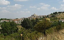
Comitini
| Comitini | ||
|---|---|---|

|
|
|
| Country | Italy | |
| region | Sicily | |
| Free community consortium | Agrigento (AG) | |
| Local name | Cumitini | |
| Coordinates | 37 ° 25 ' N , 13 ° 39' E | |
| height | 350 m slm | |
| surface | 21 km² | |
| Residents | 896 (Dec. 31, 2019) | |
| Population density | 43 inhabitants / km² | |
| Post Code | 92020 | |
| prefix | 0922 | |
| ISTAT number | 084016 | |
| Popular name | Comitinesi | |
| Patron saint | San Giacomo | |
Comitini is an outdoor parish consortium of Agrigento in the Sicily region of Italy.
Location and dates
Comitini is 16 km north of Agrigento . 896 inhabitants (as of December 31, 2019) live here on an area of 21 km². The main occupation is agriculture, olives, almonds, citrus fruits and wine are grown here. There are other jobs in a plant for rock salt extraction .
The neighboring communities of Comitini are Aragona , Favara and Grotte .
history
The municipality was founded by Gastone di Bellacera at the end of the 15th century. In 1627 the place came under the feudal possession of the Gravina family . In the 19th century the community gained importance through the sulfur mines .
Attractions
- Parish church from the 17th century
- Town hall from the 18th century
- Bellacera Palace from 1631
Web links
Commons : Comitini - collection of pictures, videos and audio files
- Information on Comitini (Italian)
Individual evidence
- ↑ Statistiche demografiche ISTAT. Monthly population statistics of the Istituto Nazionale di Statistica , as of December 31 of 2019.


