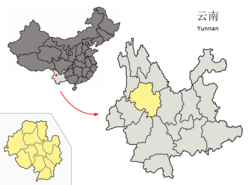
Dali (Autonomous District)
| 大理 白族 自治州 Dali |
||
|---|---|---|
|
|
||
| Coordinates | 25 ° 42 ' N , 100 ° 9' E | |

|
||
| Basic data | ||
| Country | People's Republic of China | |
| Yunnan | ||
| region | Southwest China | |
| ISO 3166-2 | CN-YN | |
| surface | 28,299 km² | |
| Residents | 3,544,000 (2015) | |
| density | 125.2 Ew. / km² | |
| founding | November 16, 1956 | |
| Post Code | 671000 | |
| Website | www.dali.gov.cn | |
| Others | ||
| status | Autonomous District | |
| Time zone | China Standard Time (CST) UTC +8 |
|
|
South gate of the old town of Dali
|
||
The autonomous district of Dali der Bai ( Chinese 大理 白族 自治州 , Pinyin Dàlǐ Báizú zìzhìzhōu ; Bai : Darl • lit Baif • cuf zirl • zirl • zox ) is located in the west of the Chinese province of Yunnan . It has an area of 29,459 km² and around 3.61 million inhabitants (end of 2016). The autonomous district is the main settlement area of the Bai people . Many of the Bai are traditionally fishermen and suffer from water pollution from local mining and industry.
Administrative structure
At the district level, Dali is made up of eight districts, three autonomous districts and one urban district. These are:
- City of Dali (大理 市), 1,468 km², 603,500 inhabitants, capital of the autonomous district, seat of the district government;
- Xiangyun County (祥云县), 2,498 km², 450,000 inhabitants, capital: Xiangcheng Township (祥 城镇);
- Circle Binchuan (宾川县), km² in 2627, 330,000 inhabitants, capital: greater community Jinniu (金牛镇);
- Midu district (弥渡 县), 1571 km², 310,000 inhabitants, main town: Micheng municipality (弥 城镇);
- District Yongping (永平县), km² in 2884, 170,000 inhabitants, capital: greater community Bonan (博南镇);
- Yunlong County (云龙 县), 4712 km², 200,000 inhabitants, main town: Nuodeng Municipality (诺 邓 镇);
- Eryuan County (洱源 县), 2961 km², 330,000 inhabitants, main town: Zibihu Municipality (茈 碧湖 镇);
- District Jianchuan (剑川县), km² in 2318, 170,000 inhabitants, capital: greater community Jinhua (金华镇);
- Heqing district (鹤庆 县), 2395 km², 260,000 inhabitants, main town: Yunhe municipality (云鹤 镇);
- Yangbi Autonomous County of the Yi (漾 濞 彝族 自治县), 1957 km², 100,000 inhabitants, main town: Cangshanxi municipality (苍 山西 镇);
- Nanjian Autonomous County of the Yi (南涧 彝族 自治县), 1802 km², 210,000 inhabitants, capital: Nanjian Township (南涧 镇);
- Weishan der Yi and Hui Autonomous County (巍山 彝族 回族 自治县), 2266 km², 300,000 inhabitants, main town: Nanzhao Municipality (南诏 镇).
Ethnic breakdown of the Dali's population (2000)
At the 2000 census, Dali had 3,296,552 inhabitants.
| Name of the people | Residents | proportion of |
|---|---|---|
| Han | 1,659,730 | 50.35% |
| Bai | 1,081,167 | 32.8% |
| Yi | 426,634 | 12.94% |
| Hui | 66,085 | 2.0% |
| Lisu | 31,972 | 0.97% |
| Miao | 10,967 | 0.33% |
| Naxi | 4302 | 0.13% |
| Achang | 3330 | 0.1% |
| Others | 12,365 | 0.38% |
See also
Web links
Commons : Dali (Autonomous Region) - collection of images, videos and audio files


