
Dennenlohe (Unterschwaningen)
|
Dennenlohe
Community of Unterschwaningen
Coordinates: 49 ° 5 ′ 46 ″ N , 10 ° 36 ′ 31 ″ E
|
|
|---|---|
| Height : | 448 m above sea level NHN |
| Area : | 6.02 km² |
| Residents : | 121 (May 25 1987) |
| Population density : | 20 inhabitants / km² |
| Incorporation : | April 1, 1971 |
| Postal code : | 91743 |
| Area code : | 09836 |
 View of Dennenlohe
|
|
Dennenlohe is a district of the community of Unterschwaningen in the district of Ansbach in Middle Franconia .
geography
The village is on the edge of the Franconian Lake District . Near Dennenlohe is the Dennenloher See , which is used for swimming, surfing and camping. The Hesselberg and the Limes are within sight . The private Dennenlohe Castle Pond is surrounded by the Dennenlohe Castle Park.
State road 2221 passes Dennenlohe and leads to Unterschwaningen (1.3 km south) or Fröschau bei Bechhofen (8 km northwest). A community road leads to Oberschwaningen to the district road AN 47 (1.4 km east).
history
The place was first mentioned in 1337 as "ze dem Taennlin". The underlying field name contains the Middle High German word "tann" (= fir ) with a diminutive suffix "-lîn" and therefore means "near the pine grove".
The Counts of Frisian rule Dennenlohe had its own Fraisch district , which it had received as a fief from the Principality of Ansbach . This also exercised the village and community rule and lordship over all properties. In the late 18th century, there were 40 property (factory building with two buildings, one mill, one brick cottage, one economy with brewing rights, 8 Sölden goods , one Söldengut with forging right one Söldengütlein, 8 houses, 11 Half houses, 6/4 houses). There was also a castle with an office building and a farm and sheep house along with other economic buildings, a bailiff's house, a castle church and a community shepherd's house. From 1797 to 1808 the place was subordinate to the Justice and Chamber Office Wassertrüdingen .
In 1806 Dennenlohe came to the Kingdom of Bavaria . As a result of the municipal edict , it was assigned to the Unterschwaningen tax district in 1809 . At the same time, the rural community of Dennenlohe was formed. In administration and jurisdiction it was subordinate to the Wassertrüdingen Regional Court and the Wassertrüdingen Rent Office ( renamed Wassertrüdingen Tax Office in 1919 , Gunzenhausen Tax Office 1932–1973 , Ansbach Tax Office from 1973 ). The jurisdiction remained with the district court Wassertrüdingen until 1879, from 1879 to 1956 the district court Wassertrüdingen was responsible, from 1956 to 1970 the district court Gunzenhausen and from 1970 to 1973 the district court Dinkelsbühl , which has been a branch of the district court Ansbach since 1973 . The administration was taken over by the newly created Dinkelsbühl district office in 1862 (renamed the Dinkelsbühl district in 1938 ). With the dissolution of the Dinkelsbühl district in 1972, Dennenlohe came to the Ansbach district. In 1961 the municipality had an area of 6.024 km². On April 1, 1971 Dennenlohe was incorporated into Unterschwaningen.
Population development
| year | 1818 | 1840 | 1852 | 1855 | 1861 | 1867 | 1871 | 1875 | 1880 | 1885 | 1890 | 1895 | 1900 | 1905 | 1910 | 1919 | 1925 | 1933 | 1939 | 1946 | 1950 | 1952 | 1961 | 1970 | 1987 |
|---|---|---|---|---|---|---|---|---|---|---|---|---|---|---|---|---|---|---|---|---|---|---|---|---|---|
| Residents | 318 | 318 | 260 | 237 | 181 | 164 | 156 | 167 | 196 | 212 | 193 | 184 | 156 | 155 | 175 | 159 | 151 | 131 | 129 | 239 | 227 | 197 | 145 | 126 | 121 |
| Houses | 54 | 42 | 38 | 41 | 33 | 32 | 32 | 31 | 32 | ||||||||||||||||
| source |
Architectural monuments
_05.jpg)
- House No. 1: Dennenlohe Castle , a baroque castle complex with a modern castle park
- House No. 10: former forester's house
- House number 12: residential building
- House No. 26: guest house with two barns
- House No. 43: Evangelical Lutheran Castle Church of St. Wolfgang
photos
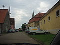
Dennenlohe through the town

Dennenlohe Castle Park

Dennenlohe Castle Park

Pond behind the castle

In the castle park


Personalities
- Friedrich Christian Lorenz Schweigger (1743–1802), Protestant theologian
- Johann Leonhard Appold (1809–1858), German copper and steel engraver
- Samuel Naumbourg (1817–1880), French cantor and composer
- Georg Scherer (1824–1909), writer and publisher of folk songs
literature
- Johann Kaspar Bundschuh : Dennenlohe . In: Geographical Statistical-Topographical Lexicon of Franconia . tape 1 : A-egg . Verlag der Stettinische Buchhandlung, Ulm 1799, DNB 790364298 , OCLC 833753073 , Sp. 583 ( digitized version ).
- Daniel Burger , Birgit Friedel: Castles and palaces in Middle Franconia . ars vivendi Verlag, Cadolzburg 2003, ISBN 3-89716-379-9 .
- August Gebeßler : City and district of Dinkelsbühl (= Bavarian art monuments . Volume 15 ). Deutscher Kunstverlag, Munich 1962, DNB 451450930 , p. 122-125 .
- Teresa Neumeyer: Dinkelsbühl: the former district (= Historical Atlas of Bavaria, part of Franconia . I, 40). Michael Laßleben, Kallmünz 2018, ISBN 978-3-7696-6562-8 .
- Wolf-Armin von Reitzenstein : Lexicon of Franconian place names. Origin and meaning . Upper Franconia, Middle Franconia, Lower Franconia. CH Beck, Munich 2009, ISBN 978-3-406-59131-0 , p. 52 .
Web links
- Dennenlohe Castle website
- Website of the Dennenloher See campsite
- Dennenlohe in the location database of the Bayerische Landesbibliothek Online . Bavarian State Library
- Dennenlohe in the Topographia Franconiae of the University of Würzburg
- Dennenlohe in the historical directory of the association for computer genealogy
Individual evidence
- ↑ a b Bavarian State Office for Statistics and Data Processing (Ed.): Official local directory for Bavaria, territorial status: May 25, 1987 . Issue 450 of the articles on Bavaria's statistics. Munich November 1991, DNB 94240937X , p. 331 ( digitized version ).
- ↑ Dennenlohe in the Bavaria Atlas
- ↑ W.-A. v. Reitzenstein, p. 52.
- ↑ T. Neumeyer, p. 403. There are incorrectly given 49 properties.
- ^ Johann Bernhard Fischer : Dennenlohe . In: Statistical and topographical description of the Burggraftum Nürnberg, below the mountain, or the Principality of Brandenburg-Anspach. Second part. Containing the economic, statistical and moral condition of these countries according to the fifteen upper offices . Benedict Friedrich Haueisen, Ansbach 1790, p. 380 ( digitized version ).
- ↑ JK Bundschuh, Vol. 1, Col. 583. According to this, there were only 17 subject families.
- ↑ a b T. Neumeyer, p. 553.
- ^ T. Neumeyer, p. 534.
- ^ Address and statistical manual for the Rezatkreis in the Kingdom of Baiern . Buchdruckerei Chancellery, Ansbach 1820, p. 71 ( digitized version ).
- ↑ a b Bavarian State Statistical Office (ed.): Official city directory for Bavaria, territorial status on October 1, 1964 with statistical information from the 1961 census . Issue 260 of the articles on Bavaria's statistics. Munich 1964, DNB 453660959 , Section II, Sp. 760 ( digitized version ).
- ^ Wilhelm Volkert (ed.): Handbook of Bavarian offices, communities and courts 1799–1980 . CH Beck, Munich 1983, ISBN 3-406-09669-7 , p. 448 .
- ↑ Only inhabited houses are given. In 1818 these were designated as fireplaces , in 1840 as houses , and from 1871 to 1987 as residential buildings.
- ↑ Alphabetical index of all the localities contained in the Rezatkkreis according to its constitution by the newest organization: with indication of a. the tax districts, b. Judicial Districts, c. Rent offices in which they are located, then several other statistical notes . Ansbach 1818, p. 17 ( digitized version ).
- ↑ Eduard Vetter (Ed.): Statistical handbook and address book of Middle Franconia in the Kingdom of Bavaria . Self-published, Ansbach 1846, p. 251-252 ( digitized version ).
- ↑ a b c d e f g h i j k Bavarian State Statistical Office (Hrsg.): Historical municipality directory: The population of the municipalities of Bavaria from 1840 to 1952 (= contributions to Statistics Bavaria . Issue 192). Munich 1954, DNB 451478568 , p. 167 , urn : nbn: de: bvb: 12-bsb00066439-3 ( digitized version ).
- ^ Joseph Heyberger, Chr. Schmitt, v. Wachter: Topographical-statistical manual of the Kingdom of Bavaria with an alphabetical local dictionary . In: K. Bayer. Statistical Bureau (Ed.): Bavaria. Regional and folklore of the Kingdom of Bavaria . tape 5 . Literary and artistic establishment of the JG Cotta'schen Buchhandlung, Munich 1867, Sp. 1004 , urn : nbn: de: bvb: 12-bsb10374496-4 ( digitized version ).
- ↑ Kgl. Statistisches Bureau (Ed.): Directory of the municipalities of the Kingdom of Bavaria according to the status of the population in December 1867 . XXI. Issue of the contributions to the statistics of the Kingdom of Bavaria. Ackermann, Munich 1869, p. 157 ( digitized version ).
- ↑ Kgl. Statistical Bureau (ed.): Complete list of localities of the Kingdom of Bavaria. According to districts, administrative districts, court districts and municipalities, including parish, school and post office affiliation ... with an alphabetical general register containing the population according to the results of the census of December 1, 1875 . Adolf Ackermann, Munich 1877, 2nd section (population figures from 1871, cattle figures from 1873), Sp. 1170 , urn : nbn: de: bvb: 12-bsb00052489-4 ( digitized ).
- ↑ K. Bayer. Statistical Bureau (ed.): Community directory for the Kingdom of Bavaria. Manufactured due to the new organization of government districts, district offices and judicial districts. Addendum to issue 36 of the articles on Bavaria's statistics. Munich 1879, p. 61 ( digitized version ).
- ↑ K. Bayer. Statistical Bureau (ed.): Community directory for the Kingdom of Bavaria. Results of the census of December 1, 1880. Issue 35 of the articles on Bavaria's statistics. Munich 1882, p. 176 ( digitized version ).
- ↑ K. Bayer. Statistical Bureau (Ed.): Localities directory of the Kingdom of Bavaria. According to government districts, administrative districts, ... then with an alphabetical register of locations, including the property and the responsible administrative district for each location. LIV. Issue of the contributions to the statistics of the Kingdom of Bavaria. Munich 1888, Section III, Sp. 1102 ( digitized version ).
- ↑ K. Bayer. Statistical Bureau (Ed.): Directory of localities of the Kingdom of Bavaria, with alphabetical register of places . LXV. Issue of the contributions to the statistics of the Kingdom of Bavaria. Munich 1904, Section II, Sp. 1167 ( digitized version ).
- ↑ Bavarian State Statistical Office (ed.): Localities directory for the Free State of Bavaria according to the census of June 16, 1925 and the territorial status of January 1, 1928 . Issue 109 of the articles on Bavaria's statistics. Munich 1928, Section II, Sp. 1205 ( digitized version ).
- ↑ Bavarian State Statistical Office (ed.): Official place directory for Bavaria - edited on the basis of the census of September 13, 1950 . Issue 169 of the articles on Bavaria's statistics. Munich 1952, DNB 453660975 , Section II, Sp. 1034 ( digitized version ).
- ^ Bavarian State Statistical Office (ed.): Official place directory for Bavaria . Issue 335 of the articles on Bavaria's statistics. Munich 1973, DNB 740801384 , p. 171 ( digitized version ).
