
Drachenfels (Middle Palatinate Forest)
| Drachenfels | ||
|---|---|---|
 Westfelsen in winter |
||
| height | 570.8 m above sea level NHN | |
| location | Rhineland-Palatinate ( Germany ) | |
| Mountains | Palatinate Forest | |
| Dominance | 10.6 km → Hohe Loog , 618.7 m | |
| Notch height | 264.8 m ↓ Sattel Bundesstrasse 37, 1 km west of Hochspeyer , altitude 306 m | |
| Coordinates | 49 ° 25 '30 " N , 8 ° 3' 11" E | |
|
||
| rock | Red sandstone | |
| Development | 1873 | |
| particularities | Remains of a Roman fortification | |

The Drachenfels is a mountain in the Middle Palatinate Forest ( Rhineland-Palatinate ) on the forest area of the district town of Bad Dürkheim . At 570.8 m above sea level NHN summit, it is the highest point in the Palatinate Forest north of the Hochspeyerbach / Speyerbach line . The Drachenfels area is designated as a nature reserve.
geography
Geographical location
The mountain lies in the western part of a triangle with a side length of about 14 km, which is formed by the Isenachtal ( B 37 ) in the north, the German Wine Route in the east and the valleys of Speyerbach and Hochspeyerbach (along the federal highway 39 ) in the southwest.
Surroundings
In the area of Drachenfels are as further destinations in the Siegfriedbrunnen that farmed former forester's house Jägerthal that is not farmed Forsthaus Kehrdichannichts , the ruins of cabins Murrmirnichtviel and Schaudichnichtum , the 1280 first documented Lambert Cross - the oldest crossroads of the Palatinate - who managed Lambert cross-hut , the Saupferch forest restaurant and the 70 hectare Kurpfalz-Park leisure and wildlife park .
description
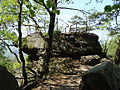
The approximately 13-hectare summit plateau made of red sandstone , clearly visible from the Rhine plain, towers over the upstream elevations, has its highest point in the northeast. It was placed under nature protection in 1972. Until 1920, a pair of short-toed eagles nestled in the rock .
The name of the mountain - like that of the nearby Siegfriedsbrunnen - is associated with the dragon from the Nibelungen saga. Below the rock, which protrudes far to the southwest, there are two caves; the small one is called the “dragon chamber”, the larger one is called the “dragon cave”. In the western part of the plateau remains of a fortification from Roman times have survived; the former ring wall is only faintly visible under vegetation. From the so-called Westfelsen in the northwest, the Donnersberg can be seen in the north, the peaks of the Hunsrück in the northwest and the city of Kaiserslautern in the west .
West rock

South rock

Sandstone massif on the southern rock

See-through chamber below the southern rock

Hiking trail on the Drachenfels


Springs on the Drachenfels

Directly at the beginning of the steep ascent to the summit there is a source at 430 m above sea level, which leads to the Kummererbrunnen ( Lage ). It was created in the 1840s by the district forester Karl Kummerer from the Jägerthal forester's house and his colleague Karl Nahm from the neighboring district. The fountain trough is marked with the initials "KK KN".
The Siegfriedsbrunnen ( Lage ) is located in a southerly direction in the valley at the foot of the Drachenfels; it is the source of the Glashüttentalbach . The Drachenfels Club has renamed the former Friedrichsbrunnen in Siegfriedsbrunnen . In the official topographic map 1: 25,000 (publisher: State Office for Surveying and Geo-Base Information Rhineland-Palatinate, 2nd edition 2010) the source is still referred to as "Friedrichsbrunnen".
tourism
traffic
Because of its central location, the Drachenfels can be reached from all sides, but only on foot; Since the area is under nature protection, it is not allowed to ride or ride mountain bikes or other two-wheelers there. The ascent is quite steep and leads over partly unpaved forest paths and paths. The next hiking car park at the Saupferch forest house , where there is a signpost of the Palatinate Forest Association , can be approached from the north - B 37 Kaiserslautern – Bad Dürkheim - via an approximately 2 km long paved road.
maintenance
The Drachenfels area is maintained by the Drachenfels Club. The association, which aims to preserve and beautify cultural monuments in and around Bad Dürkheim, was founded in 1873 and initiated the development of the Drachenfels in the same year.
Web links
References and comments
- ↑ a b LANIS: Drachenfels on a topographic map from the map service of the landscape information system of the Rhineland-Palatinate nature conservation administration. Retrieved May 16, 2017 .
- ↑ a b c Chronicle. Drachenfels-Club, accessed on July 24, 2020 .
- ↑ a b Monuments. Drachenfels-Club, accessed on July 24, 2020 .
- ↑ The term "fountain of grief" is wrong; see. The Palatinate on the Rhine . Volumes 44-45 (1971), p. 129.
Train station | Castle Schlosseck | Castle Church | Drachenfels | Dürkheim House | Flag tower | Forsthaus Jägerthal | Graduation tower | Hardenburg | Pagan wall | Weilach farm ruins | Limburg Monastery | Seebach Monastery Church | Kriemhildenstuhl | Kurhaus | Lambert's Cross | Laurahütte | Ludwig Church | Kehrdichannasst Castle | Murrmirnichtviel Castle | Schaudichnichtum Castle | Castle Church | Vigilio Tower | Villa Denis | Villa rustica Weilberg
Note: This navigation bar contains those cultural monuments with their own article. All other cultural monuments are included in the corresponding list .

At the Bechsteinkopf | At the Goldberg | At the Hinterberg | At the Kämmertsberg | At the Limburgberg | At the mud mountain | On the crow's cave | Drachenfels (Middle Palatinate Forest) | Felsenberg-Berntal | Forster Bruch | In the tree garden | In high law | In the Rüster | Lochbusch-Königswiesen | Marlachwiesen | Mittelberg