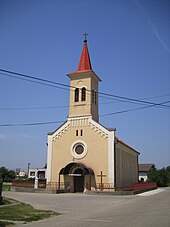
Dulovce
| Dulovce | ||
|---|---|---|
| coat of arms | map | |

|
|
|
| Basic data | ||
| State : | Slovakia | |
| Kraj : | Nitriansky kraj | |
| Okres : | Komarno | |
| Region : | Podunajsko | |
| Area : | 12,380 km² | |
| Residents : | 1,685 (Dec 31, 2019) | |
| Population density : | 136 inhabitants per km² | |
| Height : | 136 m nm | |
| Postal code : | 946 56 | |
| Telephone code : | 0 35 | |
| Geographic location : | 47 ° 52 ' N , 18 ° 16' E | |
| License plate : | KN | |
| Kód obce : | 501123 | |
| structure | ||
| Community type : | local community | |
| Administration (as of November 2018) | ||
| Mayor : | Andrei Hamran | |
| Address: | Obecný úrad Dulovce Hlavná 33 94656 Dulovce |
|
| Statistics information on statistics.sk | ||
Dulovce (up to 1948 Slovak "Nová Ďala"; German Neudala , Hungarian Újgyalla ) is a municipality in western Slovakia .
location
It is located in the Danube lowlands , seven kilometers from Hurbanovo and 18 kilometers from Komárno .
history
The place was first mentioned as Gyalla in 1329 .
Until 1918, the place in Komorn County belonged to the Kingdom of Hungary , then came to the newly formed Czechoslovakia, but became part of Hungary again from 1938 to 1945 due to the First Vienna Arbitration . Since 1993 it has been part of today's Slovakia.
Web links
Commons : Dulovce - collection of images, videos and audio files

