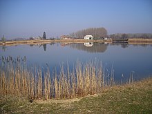
Klížska Nemá
| Klížska Nemá Kolozsnéma |
||
|---|---|---|
| coat of arms | map | |

|
|
|
| Basic data | ||
| State : | Slovakia | |
| Kraj : | Nitriansky kraj | |
| Okres : | Komarno | |
| Region : | Podunajsko | |
| Area : | 11,953 km² | |
| Residents : | 457 (Dec. 31, 2019) | |
| Population density : | 38 inhabitants per km² | |
| Height : | 115 m nm | |
| Postal code : | 946 19 (Post Office Číčov ) | |
| Telephone code : | 0 35 | |
| Geographic location : | 47 ° 45 ' N , 17 ° 49' E | |
| License plate : | KN | |
| Kód obce : | 501191 | |
| structure | ||
| Community type : | local community | |
| Administration (as of November 2018) | ||
| Mayor : | Rozália Szalay | |
| Address: | Obecný úrad Klížska Nemá Hlavná 52 946 19 Číčov |
|
| Website: | www.klizskanema.sk | |
| Statistics information on statistics.sk | ||
Klížska Nemá (Hungarian Kolozsnéma ) is a municipality in southwest Slovakia with 457 inhabitants (as of December 31, 2019). It is located in Okres Komárno , part of the Nitriansky kraj .
geography
The community is located in the Slovakian Danube lowlands , more precisely in the south-eastern part of the Great Schüttinsel . The Danube flows behind a protective dam and forms the border between Slovakia and Hungary . The center of the village is at an altitude of 115 m nm and is 18 kilometers from Veýký Meder and 30 kilometers from Komárno .
Neighboring communities are Trávnik in the west and north, Veľké Kosihy in the northeast and east, Nagyszentjános in the southeast and Gönyű in the south.
history
Klížska Nemá was mentioned in writing for the first time in 1226 (according to other sources not until 1268) as Nema , at that time as the possession of Komorn Castle. Other historical names include Vrnepeniewma (1396), Kolosnema (1460) and Kollos-Néma (1773). In the Middle Ages, part of the village was owned by the Pannonhalma Abbey , and families such as Kolosnémai , Tártsai , Vas , Dézy and Lossonczy owned shares until the 19th century . The community was devastated during the Turkish wars. In 1715 the village had two mills and 40 households. Fishing and basketry were common occupations.
Until 1918/1919 the place in Komorn County belonged to the Kingdom of Hungary and then came to Czechoslovakia or now Slovakia. As a result of the First Vienna Arbitration Award , it was once again part of Hungary between 1938 and 1945.
population
According to the 2011 census, there were 520 inhabitants in Klížska Nemá, including 482 Magyars , 31 Slovaks , three Czechs and one German . One resident indicated a different ethnic group and two residents gave no information about the ethnic group .
288 residents committed to the Roman Catholic Church, 103 residents to the Reformed Church, four residents to the Evangelical Church AB, two residents to the Greek Catholic Church and one resident to the Brethren. 48 inhabitants were without a denomination and the denomination of 74 inhabitants was not determined.
Buildings
- Reformed church from 1794, which was created by converting a Romanesque rotunda from the 12th century
- Roman Catholic Guardian Angel Church from 1884
Individual evidence
- ↑ Results of the 2011 census (Slovak) ( Memento of the original from March 5, 2016 in the Internet Archive ) Info: The archive link was inserted automatically and has not yet been checked. Please check the original and archive link according to the instructions and then remove this notice.
- ↑ Klížska Nemá , apsida.sk (Slovak), accessed on April 29, 2018
Web links
- Entry on e-obce.sk (Slovak)


