Felgentreu (Nuthe-Urstromtal)
|
Rim-true
Municipality Nuthe-Urstromtal
Coordinates: 52 ° 5 ′ 41 ″ N , 13 ° 1 ′ 3 ″ E
|
|
|---|---|
| Height : | 50 m above sea level NHN |
| Area : | 9.7 km² |
| Residents : | 449 (December 31, 2016) |
| Population density : | 46 inhabitants / km² |
| Incorporation : | December 6, 1993 |
| Postal code : | 14947 |
| Area code : | 033734 |
|
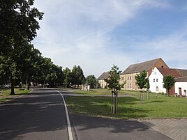
Village street
|
|
The village of Felgentreu has been one of 23 districts of the Nuthe-Urstromtal community in the Teltow-Fläming district in Brandenburg since 1993 . The place has 449 inhabitants (as of December 31, 2016).
location
Felgentreu is located around 11 km west of Luckenwalde . To the north is the district of Zülichendorf . It follows clockwise: Gottsdorf , Frankenfelde , Luckenwalde, the nature reserve Forst Zinna Jüterbog -Keilberg, Bardenitz (to Treuenbrietzen ) and Niebelhorst. The water-rich area is traversed by several ditches, including the Vossgraben and the Nuthegraben .
history
The name of the place could be derived from the Sorbian welike drewo , which means high deciduous forest or moist deciduous forest . As Velgendreve, the place was owned by the Zinna monastery from 1285 to 1553 . 1285 is therefore also the year of the first documentary mention. From the time of the Thirty Years War , 34 mounted soldiers have survived. During the Wars of Liberation , the place was affected by looting; In addition, there were several famines due to poor harvests, which led to the impoverishment of the population. In several major fires, the mainly half-timbered buildings were destroyed and gradually replaced by stone structures. At the end of the 19th century, the farmers began to drain the bordering swampy area and to use the land obtained in this way for agriculture and cattle breeding. In 1897 they set up a dairy for processing milk. At peak times around 250 kg of butter was produced every day.
In the time of National Socialism in 1935 plans arose to give up the place in favor of a military training area . This led to the fact that in autumn 1936 the majority of the residents left the place; In 1937 it was completely abandoned for military use. During the Second World War , a subcamp of the main camp III A for prisoners of war and a subcamp of the prison in Luckau were set up. After the end of the war, the place was settled again, mainly by expellees from the east. They tore down the now dilapidated church. Around 30 new farmers began growing vegetables in 1948, which developed into a market garden in the coming decades during the GDR era . In 1952, the farmers built a machine-tractor station that was responsible for the southern parts of the old Luckenwalde district and the district town. In the same year an agricultural production cooperative was established , which cultivated 358 hectares . A blacksmith's shop, a carpentry shop, a bakery, a basket-making shop, a grocery store and two inns were built. On December 6, 1993, Felgentreu was incorporated into Nuthe-Urstromtal. In 2010 the place celebrated its 725th anniversary.
Culture and sights
- The Felgentreu village church was built in 1987 in the style of a Finnhütte . The church furnishings are modern.
- A mill in the street Zum Sportplatz , a stable building in the Felgentreuer Dorfstraße and a single-family house in the Kemnitzer Straße are the architectural monuments of the place (see list of architectural monuments in Nuthe-Urstromtal ).
- The history of the place is presented in a chronicle room in the Naturhaus Felgentreu.
- Memorial to those who fell from the world wars on the village green
- A circular hiking trail leads from Felgentreu into the Nuthe-Nieplitz Nature Park and into the Forst Zinna Jüterbog -Keilberg nature reserve , which was created on the site of the former military training area. Visitors can reach Pechüle , Frankenförde and Luckenwalde on cleared, signposted paths . 600 different species of fern and flowering plants have been identified on the area
Economy and infrastructure, associations
To the east of the village is the 18-hectare Felgentreu biogas park with ten biogas plants , a nursery, an agricultural cooperative and several farmers, small businesses and craft businesses. Private individuals and businesses offer overnight stays for tourists.
The district road 7218 runs through the village, which branches off from the north in the village to the east and thus establishes a connection to federal road 2 or to Luckenwalde to federal road 101 . Line 755 of the Teltow-Fläming transport company connects the town with Luckenwalde and Kemnitz .
Six clubs are active in the village. They organize regular events such as a village festival, the Felgentreuer hiking day or the Felgentreuer Advent lighting.
Web links
- True to the rim on the website of the Nuthe-Urstromtal community
- Dorfgemeinschaft Felgentreu eV
- Clubs - Felgentreu
- Felgentreu in the RBB broadcast Landschleicher on February 11, 2007
Individual evidence
- ↑ Felgentreu district , website of the Nuthe-Urstromtal community, accessed on March 2, 2017.
- ↑ a b Felgentreu on the website of the Nuthe-Urstromtal community ( memento of the original from July 29, 2016 in the Internet Archive ) Info: The archive link has been inserted automatically and has not yet been checked. Please check the original and archive link according to the instructions and then remove this notice.
- ↑ Felgentreu district , website of the Nuthe-Urstromtal community, accessed on March 2, 2017.
- ↑ Information board for the Pechüle - Felgentreu circular hiking trail , set up on Zinnaer Straße by the nature park, March 2017.
- ^ Changes in the municipalities of Germany, see 1993 StBA


