
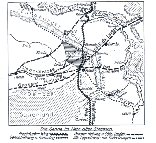
Frankfurt way
A former Via Regia from the Frankfurt am Main area via Paderborn and Minden to Bremen has been known as Frankfurter Weg since the 17th century . He connected the areas of the Rhine and Main with those of the Weser and the North Sea . In Lower Saxony in particular, the same street was named Bremer Weg after its other end point , while in Hessian it retained its old name and meaning Wagenstrasse (Wängstrasse, Weinstrasse ). It was known as the Zinnstrasse and one of the Amber Roads since ancient times .
course
From Bremen to the edge of the low mountain range near Minden, routes close to the Weser could be used. At Minden, the Frankfurter Weg crossed the east-west routes Hellweg in front of Santforde and Hellweg under the mountain .
On the flood-free Weser terrace below the Wittekindsberg and above the Weser floodplain, archaeological excavations in Barkhausen in 2008 discovered medieval wagon tracks parallel to today's road, which indicate the course of the Frankfurter Weg west of the Weser through Porta Westfalica . According to the original cadastre from 1837, the Alte Poststraße ran here. The use of this stretch of route must be very old, because the remains of two Roman marching camps from the time of the Drusus campaigns (12–9 BC) and from the beginning of our era have been excavated nearby .
The Werre was crossed by the Frankfurter Weg through the Steinfurt near Rehme , while a junction went over the Weserfurt near Rehme to Holtrup- Vössen and then east of the Weser as a salt road in the direction of Lüneburg . At higher water levels, the more northerly Weserfurt von Aulhausen (Office Hausberge ) was used. From the 13th century there was an initially wooden bridge over the Weser in Minden at the site of the ford there. Occasionally, at the Porta Westfalica breakthrough in the Weser, the floods created an interruption in the Frankfurter Weg and its branch. So in 784 Charlemagne had to break off a planned campaign into the northern tribal area of the Saxons at this point.
At Rehme the Kölner Straße branched off to the southwest in the direction of Herford and Bielefelder Pass , while the Frankfurter Weg forked in the directions of Vlotho (Weserhafen) and Exter . This created a junction with old streets in five directions:
- northwest over the Werrefurt to Bremen
- northeast over the Weserfurt to Hamburg and Lübeck
- southwest over the Kölner Straße through the Osning ( Teutoburg Forest ) and over Rheda and Hamm to the Rhine
- south-southeast via Vlotho, Lemgo and Detmold to Paderborn and on to the Main
- south-southwest via Exter, Salzuflen and Schötmar to Paderborn.
In Wehrendorf (now in the Valdorf district of the city of Vlotho ) there was a crossing with another important east-west route from Braunschweig and Hildesheim to Osnabrück and Münster , known in this area as Herford Street , at the latest since the 13th century . In 1556 there was still a land toll here (probably in the area of today's Waddenbergstrasse). A sacred building called a chapel is mentioned as early as around 900 in Wehrendorf. It was considered a ruin in the year of demolition in 1828. This is probably where the early medieval intersection of the old streets lay. The current church was only built in 1969, during this period, after the parish was removed from the Valdorf community, an independent parish was founded in Wehrendorf.
The Herford road crossed the western route of the Frankfurter Weg in Exter and there also took up a road from the important Weser port of Vlotho, through which large parts of the trade in the Hanseatic city of Herford were handled.
The Frankfurter Weg used the Dörenschlucht gorge through the Osning (Teutoburg Forest) .
He crossed the Westphalian Hellweg in Paderborn, where archaeological evidence of the interface at the deserted Balhorn was achieved a little east of the "Paderborn-Zentrum" motorway junction.
With an old road from Cologne via Hagen , Iserlohn , Arnsberg and Brilon to the Weser near Herstelle , a crossing was created in Horhausen (since the 13th century Niedermarsberg ), which was secured by the Eresburg (today Obermarsberg ). From this old street another old street branched off at Bredelar via Arolsen and Dörnberg to Kassel , which created a second crossing with Frankfurter Weg just a little south of the Eresburg. These old road crosses were so important for the old Saxon times that the tribal sanctuary of the Irminsul is said to have been here until 772 . On October 12, 900, Abbot Bovo von Corvey was granted market , coin and customs rights by King Ludwig IV for his monastery property in Niedermarsberg (documented as "villa Horohusun") . This was one of the earliest German market rights, which also made the Frankfurter Weg significantly more important at the time.
After two finds of Roman road sections on the route from Niedermarsberg to the Weser in 1880, a Roman road through the valley of the Diemel was suspected. In the early Middle Ages at the latest, the road to the Weser parted from the Diemel in Scherfede , while the road to the Diemel led via Warburg to Kassel.
From the 16th century, the Höhenweg from the Marsberg area south of the Diemel via Rhoden , Wethen , the Diemelfurt near Germete , Daseburg , Rösebeck and Borgentreich to the Weserhafen Beverungen was referred to as the Eiserweg ( iron path ).
The course of the Frankfurter Weg in Hesse describes the Weinstrasse (Wagenstrasse, Wängstrasse).
history
The founding of the diocese of Paderborn through the presence of Charlemagne and Pope Leo III, who fled from Rome to Saxony because of accusations of adultery, was essential for the western course of this old road compared to the more original north-south connection directly on Fulda and Weser . in the year 799. Due to the destruction of the Archdiocese of Hamburg, founded in 831, by the Normans and its relocation to Bremen in 845, the northern end stretch of this old road, also known as the Bremer Weg, was formed.
One of the users of the path that was occupied early was the Benedictine abbot Nikulás von Munkaþverá from a monastery near Akureyri in northern Iceland. He undertook a pilgrimage to Rome from 1149 to 1154 and then wrote a "guide" (Leiðarvisir) until 1159. Coming from Denmark he crossed the Elbe between Itzehoe and Stade with a ferry and used the Allerfurt near Verden (Furdi). West of the Weser he moved via Nienburg (Nyjoburg) to the Weserfurt in Minden (Mundioburg), where he visited the Episcopal Church of St. Peter and noticed the change of dialect. After two day trips he reached Paderborn (Poddobrunnar) with the Bishop's Cathedral of St. Liborius. He found the saint's relics there. From there he went on four day trips via Hortus (Horhausen ad Diemel?), The Gnitaheidr and Kiliandr to Mainz (Meginzoborg).
The first still wooden Weser bridge in Minden was first mentioned in a document dated June 12, 1258. The then relatively flood-safe ford Ouwelhusen (Aulhausen in the Hausberge district) then lost its importance. At the important Weser port of Vlotho, there has also been evidence of a ferry for the dry transfer of wagons since 1423. On December 5th, 1486 the diocese of Minden sold the monastery ford Aulhausen with the fish weir to Heinrich von Beveren, citizen of Minden.
The bridge over the Werre in Gohfeld, first mentioned in 1428, attracted traffic on the Frankfurter Weg from the 15th century. Connections between the two main routes, such as those from Lemgo to Salzuflen or from the Weserhafen Vlotho via Exter to Herford, gained, the fords at Rheme lost their importance.
In the Battle of Vlotho on October 17, 1638, the Gohfelder Bridge was destroyed by the (Catholic) Imperial Cavalry under Count Westerholt, in order to cut off the retreat of the Protestant-Swedish army from the siege of Lemgo to the fortress of Minden.
On August 1, 1759, French and British-German troops fought at Gohfeld over this strategically important bridge.
literature
- Hiking Club Porta Westfalica: Der Frankfurter Weg ( Memento from December 10, 2013 in the Internet Archive )
- Jost Wedekin Heimatbuch der Stadt Wünnenberg HrsG Stadt Wünnenberg, 1987, total production Paderborn printing center
Individual evidence
- ↑ Old routes around Paderborn, Hamborn Castle website, accessed on May 19, 2010
- ↑ A map with the section from Korbach, via Paderborn through the Dörenschlucht to Minden
- ↑ Hannelore Kröger, Werner Best: A multi-periodical site in Porta Westfalica-Barkhausen on the Weser. In: Archeology in Westphalia-Lippe 2009. Published by LWL-Archeologie für Westfalen and the Antiquities Commission for Westphalia 2010, ISBN 978-3-941171-42-8 , pp. 159–161.
- ^ Bettina Tremmel: Augustan marching camp in Porta Westfalica-Barkhausen "On the Lake". In: Archäologie in Westfalen-Lippe 2010. Published by the LWL-Archäologie für Westfalen and the Antiquities Commission for Westphalia 2011, ISBN 978-3-941171-64-0 , pp. 79–81.
- ^ Regesta Imperii to 784 = RI I n.266e in: Regesta Imperii Online, (accessed on February 9, 2015).
- ↑ August-Wilhelm König: He has to come through this hollow alley! With the ravines in traffic history. In: Kreisheimatverein Herford Historical yearbook for the Herford district. (Volume 14), Publishing House for Regional History, Bielefeld 2007, ISBN 978-3-89534-664-4 .
- ↑ Wolfgang Mager: The land register of the county of Ravensburg from 1556. Part 3, Münster 1997, ISBN 3-402-06814-1 , p. 320.
- ^ Karl Grossmann: History of the community of Valdorf and its farmers, Valdorf 1955, p. 213.
- ^ Georg Eggenstein: Balhorn-The place at the street cross. In: A world in motion. On the way to centers of the early Middle Ages. Book accompanying the group exhibition, edited by Norbert Börste and Georg Eggenstein, Munich (among others) 2008, ISBN 978-3-422-06801-8 , pp. 116-120.
- ↑ Annales regni Francorum 772: Et inde perrexit partibus Saxoniae prima vice, Eresburgum castrum coepit, ad Ermensul usque pervenit et ipsum fanum destruxit et aurum vel argentum, quod ibi repperit, abstulit. Et fuit siccitas magna, ita ut aqua deficeret in supradicto loco, ubi Ermensul stabat. Source: Regesta Imperii , Charlemagne - RI I n.149d (accessed February 11, 2015)
- ↑ Annales Patherbrunnenses 1,236 to 900 from the Regesta Imperii Online = RI I n. 1990 (accessed on February 14, 2015).
- ↑ “Landstraßen 16.-18. Century". Historical atlas of Hessen. In: Landesgeschichtliches Informationssystem Hessen (LAGIS). Hessian State Office for Historical Cultural Studies (HLGL), accessed on February 12, 2015 .
- ↑ Reinhard Köhne, Wilfried Reininghaus (ed.): Mining, smelting and hammer works in the Duchy of Westphalia in the Middle Ages and the early modern period (= publications of the Historical Commission for Westphalia. Old series), Münster 2008, pp. 283–291.
- ↑ Óláfr Ormsson from Snæfellsnes in West Iceland: Leiðarvisir. Manuscript from 1387 (Arnamagnae Collection, AM 194 / 8vo, Copenhagen)
- ↑ Heinz-Peter Mielke: The Weser Bridge through the ages (catalog for the exhibition of the Minden Museum on the occasion of the new construction of the Weser Bridge). Self-published by Mindener Museum, 1978.
- ↑ Certificate from Abbess Ilsabein von Hilvertinchusen of the Vlotho monastery. State Archives Münster, Ravensberger Documents No. 63
- ^ Document from Bishop Heinrich von Minden dated December 5, 1486 in the digital Westphalian document database (DWUD), accessed on February 8, 2015.
- ^ Ludwig Koechling: Rehme at the time of the Carolingians. In: 1200 years of Rehme. Rehme 1953, p. 94.
- ^ Friedrich Wilhelm Barthold: History of the great German war from the death of Gustav Adolf with special regard to France. Second part: From the election of Ferdinand III. to the Roman kings until the conclusion of the Westphalian peace. Verlag von SG Liesching, Stuttgart 1843, p. 139.
- ↑ 370 years ago in Valdorf. In: Mindener Tageblatt. October 23, 2008, accessed February 13, 2015.
- ↑ Christoph Gottlieb Richter: The third book of the history of the war between the Prussians and their allies, and the Austrians and their allies, which writes the war from the month Thebeth of the 5519 year to the 11th Thebeth of the 5520 year, according to the account of Christians in the 1759 year, as described by R. Simeon Ben Jochai, in an honest way, printed in the year of the Christians 1760. p. 247.
Coordinates: 52 ° 14 ′ 37.4 " N , 8 ° 57 ′ 29.3" E