
Göhren (near Altenburg)
| coat of arms | Germany map | |
|---|---|---|
.png)
|
Coordinates: 50 ° 58 ' N , 12 ° 22' E |
|
| Basic data | ||
| State : | Thuringia | |
| County : | Altenburger Land | |
| Management Community : | Rositz | |
| Height : | 225 m above sea level NHN | |
| Area : | 8.61 km 2 | |
| Residents: | 413 (Dec. 31, 2019) | |
| Population density : | 48 inhabitants per km 2 | |
| Postal code : | 04603 | |
| Area code : | 03447 | |
| License plate : | ABG, SLN | |
| Community key : | 16 0 77 008 | |
| Community structure: | Main town, 4 districts | |
| Address of the municipal administration: |
Eisenberger Strasse 7 04603 Göhren |
|
| Website : | ||
| Mayor : | Frank Eichhorn (Fire Brigade Association) | |
| Location of the community of Göhren in the Altenburger Land district | ||
  |
||

Göhren is a municipality in the Altenburger Land district in Thuringia . It belongs to the administrative community Rositz .
geography
The municipality of Göhren is located with the districts west of the city of Altenburg in the Zeitzer-Altenburger-Lösshügelland , a branch of the Leipzig lowland bay . In terms of traffic, the districts are connected to traffic with the state road 1362, the district road 210 and local connecting routes . The district of Göhren is located on the steeper right valley slope of the Kleiner Jordan, which drains into the Pleiße via the blue tide .

Gasthof “Zum kleine Jordan” in Göhren
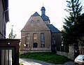
Church in Gödern

Church in Romschütz


Neighboring communities
Neighboring municipalities are the cities of Altenburg and Schmölln and the municipalities of Göllnitz , Lödla , Monstab and Starkenberg .
Community structure

Districts are Göhren (1181–1214), Gödern (1165–1170), Lossen (1165–1170), Lutschütz (1185–1214) and Romschütz (November 1, 1254). (First documentary mention in brackets)
history
Göhren was first mentioned in a document between 1181 and 1214. The Alstorbian place name "Goren", mentioned around 1200, describes its topographical location as "place on the mountain". Originally the place belonged to the possession of the burgraves of Leisnig , later spiritual institutions of the Altenburger Land also acquired possessions in the place. In 1445 there were six farms in Göhren.
Göhren belonged to the Wettin office of Altenburg , which was under the sovereignty of the following Ernestine duchies from the 16th century due to several divisions in the course of its existence : Duchy of Saxony (1554 to 1572), Duchy of Saxony-Weimar (1572 to 1603), Duchy of Saxony-Altenburg (1603 to 1672), Duchy of Saxony-Gotha-Altenburg (1672 to 1826). When the Ernestine duchies were reorganized in 1826, the place came back to the duchy of Saxony-Altenburg. After the administrative reform in the duchy, it belonged to the eastern district (until 1900) and to the Altenburg district office (from 1900). From 1918 the village belonged to the Free State of Saxony-Altenburg , which was added to the State of Thuringia in 1920. In 1922 it came to the district of Altenburg .
On July 1, 1950, Romschütz, Gödern with its district Lutschütz and Lossen with its district Steinwitz were incorporated , but without the district Wieseberg. The favorable traffic situation on the Alte Geraer Landstrasse was a major reason for choosing Göhren as the main town. Steinwitz was reclassified to Altenburg on January 4, 1953 . During the second district reform in the GDR in 1952, the existing states were dissolved and the districts were redesigned. Thus, the community came Göhren with the district Altenburg at the Leipzig district , since 1990 as a county belonged to Altenburg Thuringia and opened in 1994 Altenburger in the district of the country.
With its eight half-timbered houses, Göhren is one of the half-timbered settlements in the Altenburger Land. In the valley on the former Geraer Straße, today's Eisenberger Straße, the once regionally known inn "Zum Deutschen Jordan" stands directly on the "Kleiner Jordan". At the end of the 19th century, the Böhnersche Gasthof was the destination of dancers in the region, especially because of its large hall.
Population development
Development of the population (as of December 31st) :
|
|
|
|
|
- Data source: Thuringian State Office for Statistics
Incorporations
| Former parish | date | annotation |
|---|---|---|
| Gods | July 1, 1950 | |
| Lossen | July 1, 1950 | on July 1, 1950, the district of Wieseberg was reclassified to Lödla |
| Lutschütz | October 1, 1938 | Incorporation to Gödern |
| Romschütz | July 1, 1950 | |
| Steinwitz | August 1, 1936 | Incorporation to Lossen, January 4th 1953 reclassification to Altenburg |
politics
Municipal council
The composition of the municipal council , which consists of six members, has been in the local elections on May 25, 2014 in a majority vote elected. All municipal councils belong to the fire brigade association.
The turnout was 62.4% (± 0.0% p).
mayor
Frank Eichhorn, appointed by the local fire brigade association, has been mayor since the election on June 5, 2016. He was elected with a majority of 88.5% without opposing candidates and a voter turnout of 46.2% (–6.3% p). Previous holders of office were Almut Klein (CDU) until 2004 and Roberto Bauer from the fire brigade association until 2016.
Personalities
- Hellmut Kasel (1906–1986), architect
Web links
Individual evidence
- ^ Population of the municipalities from the Thuringian State Office for Statistics ( help on this ).
- ↑ Wolfgang Kahl : First mention of Thuringian Cities and Villages, Rockstuhl Publishing House, Bad-Langensalza, 2010, ISBN 978-3-86777-202-0 , pp. 91, 170, 172, 237
- ^ Wolfgang Kahl: First mention of Thuringian towns and villages. A manual. Rockstuhl Verlag, Bad Langensalza, 2010, ISBN 978-3-86777-202-0 , p. 91
- ^ The Altenburg Office in the book Geography for all Stands , from p. 201
- ^ The locations of the Altenburg district from p.83
- ↑ The eastern district of the Duchy of Saxony-Altenburg in the municipal directory 1900
- ^ The Altenburg district office in the municipality register 1900
- ↑ Steinwitz on gov.genealogy.net
- ↑ Results of the mayoral election for the Thuringia regional returning officer, accessed on August 1, 2016
Altenburg | Dobitschen | Fockendorf | Gerstenberg | Goehren | Göllnitz | Göpfersdorf | Gößnitz | Haselbach | Heukewalde | Heyersdorf | Jonaswalde | Kriebitzsch | Langenleuba-Niederhain | Löbichau | Lödla | Lucka | Mehna | Meuselwitz | Monstrous | Nobitz | Ponitz | Poster stone | Rositz | Schmölln | Starkenberg | Thonhausen | Treben | Vollmershain | Windischleuba