Jenštejn
| Jenštejn | ||||
|---|---|---|---|---|
|
||||
| Basic data | ||||
| State : |
|
|||
| Region : | Středočeský kraj | |||
| District : | Praha-východ | |||
| Area : | 509 ha | |||
| Geographic location : | 50 ° 9 ' N , 14 ° 37' E | |||
| Height: | 232 m nm | |||
| Residents : | 1,247 (Jan 1, 2019) | |||
| Postal code : | 250 73, 250 91 | |||
| traffic | ||||
| Street: | Horní Počernice - Podolanka | |||
| structure | ||||
| Status: | local community | |||
| Districts: | 2 | |||
| administration | ||||
| Mayor : | Zuzana Bezvodová (as of 2007) | |||
| Address: | 9. května 60 250 73 Jenštejn |
|||
| Municipality number: | 538264 | |||
| Website : | www.jenstejn.cz | |||
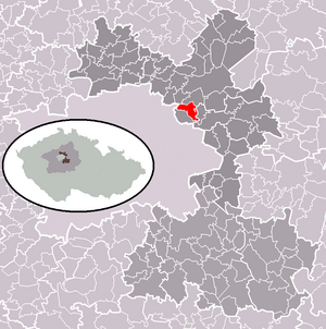
| Location of Jenštejn in the Praha-východ district | ||||

|
||||
Jenštejn (German Jenstein , formerly Jenzenstein or Genzenstein ) is a municipality in the Czech Republic . It is located 15 kilometers northeast of the city center of Prague and belongs to the Okres Praha-východ .
geography
Jenštejn is located one kilometer from the Prague city limits in the headwaters of Jenštejnský potok. Expressway 10 / E 65 runs south of the district of Dehtáry .
Neighboring towns are Cvrčovice in the north, Dřevčice and Zápy in the north-east, Svémyslice in the east, Dehtáry in the south-east, Radonice in the south, Vinoř in the south-west, Přezletice in the west and Podolanka in the north-west.
history
The village of Jenczenstein was founded in the first half of the 14th century together with a small castle by Jenc from Janovice. In 1368 the notary of the royal chamber, Pavel von Vlašim, bought the property and called himself Paulus de Jenczenstein from then on. Eight years later, his sons Martin, Johann , Wenzel and Paul were mentioned. A new castle complex was built under Pavel von Vlašim, which became the center of a rule. Ownership has changed frequently since the 15th century. The last owner of the estate was Jan Dobřichovský von Dobřichov; after his death in 1583 his property fell to the Bohemian Chamber . In 1585 Jenštejn was annexed to the Brandýs rule . In 1597 the castle was described as desolate.
During the Thirty Years War, the Swedes under Johan Banér burned Jenstein down in 1640 and also set fire to the castle. Between 1655 and 1660 the desolate estates were cultivated again. In the second half of the 17th century Jenstein was raised to a town and was granted market rights. After the Second World War, a huge landfill was built north of Jenštejn, directly on the protected valley of the Vinořský potok, in which waste from Prague factories was stored. After the Velvet Revolution began in 1989, the removal of the ecological and urban damage caused by the landfill.
Community structure
The municipality Jenštejn consists of the districts Dehtáry ( Dechtar ) and Jenštejn ( Jenstein ) and the settlement Nový Jenštejn.
Attractions
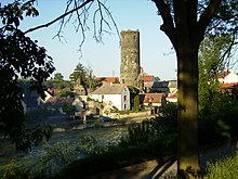
- The ruins of the Jenštejn Castle with the 22 meter high keep , which can be seen from afar
- Chapel in Jenštejn, built in 1855
- Chapel in Dehtáry
Web links
Individual evidence
- ↑ Český statistický úřad - The population of the Czech municipalities as of January 1, 2019 (PDF; 7.4 MiB)


