
Golegã
| Golegã | ||||||
|---|---|---|---|---|---|---|
|
||||||
| Basic data | ||||||
| Region : | Alentejo | |||||
| Sub-region : | Lezíria do Tejo | |||||
| District : | Santarém | |||||
| Concelho : | Golegã | |||||
| Coordinates : | 39 ° 24 ′ N , 8 ° 29 ′ W | |||||
| Residents: | 3845 (as of June 30, 2011) | |||||
| Surface: | 38.4 km² (as of January 1, 2010) | |||||
| Population density : | 100 inhabitants per km² | |||||
| Postal code : | 2150 | |||||
| politics | ||||||
| Address of the municipal administration: | Junta de Freguesia da Golegã Largo D. Manuel I 2150-128 Golegã |
|||||
| Golegã district | ||||||
|
||||||
| Residents: | 5913 (as of June 30, 2011) | |||||
| Surface: | 84.31 km² (as of January 1, 2010) | |||||
| Population density : | 70 inhabitants per km² | |||||
| Number of municipalities : | 3 | |||||
| administration | ||||||
| Administration address: | Câmara Municipal da Golegã Largo D. Manuel I 2150-128 Golegã |
|||||
| President of the Câmara Municipal: | Rui Manuel Medinas Duarte ( PS ) | |||||
| Website: | www.cm-golega.pt | |||||


Golegã [ ɡoɫɯˈɡɐ̃ ] is a small town ( vila ) in Portugal . The district is known for its horse and bull breeding. Every year, the Feira Nacional do Cavalo, a nationally known riding festival with exhibition and fair, takes place here. Golegã is a capital of the horse breeding of the Portuguese horse breed Lusitano .

The main Manueline church of Golegã
|
history
Finds prove a settlement since the Copper Age . The location on rivers and later important connecting roads favored the settlement. So from Roman times a. a. Remains of houses found. After the Moors conquered the land in 711 , the area underwent some development, especially in agriculture. Excavations from this Arab period are numerous here, especially agricultural implements and houses with their typical courtyards.
In the course of the Christian Reconquista , Golegã gained strategic importance due to its location on the defense line of the Knights Templar between the castles of Almourol , Santarém and Tomar . This location on strategic connecting routes and the productive soils of the surrounding area ensured economic development, which was also reflected in increasing trade and a growing population. In 1520, Golegã was granted city rights by King D. Manuel I , who temporarily chose the place as a summer residence. In 1534 King D. João III. the place to the small town ( Vila ).
Golegã is a typical region of Ribatejo , and has been famous since the 19th century for its horses and bulls for bullfighting . In addition, the fruit, vegetables and grain production on the fertile soils in the district is known to this day.
Horse breeding

Azinhaga and Golegã are known for their long horse breeding tradition. Even Sancho I (1154-1211), the second king of Portugal from the home Burgundy , had as a prince in the region a stud. For the Saint Martin's market (Feira de São Martinho) around November 11th ( Martin’s Day ), lovers of Portuguese horses meet for the Feira Nacional do Cavalo in Golegã. The well Feira Internacional do Cavalo Lusitano called horse show takes place every year since the 17th century and established the reputation of the place as a nationally known horse town, a number of stud farms in the surrounding areas especially the breeding of Lusitanopferdes pay.
administration
circle
Golegã is the administrative seat of a district of the same name ( concelho ) in the Santarém district . On June 30, 2011, the district had 5913 inhabitants on an area of 84.3 km².
The neighboring areas are (starting clockwise in the north): Vila Nova da Barquinha , Chamusca , Santarém , Torres Novas and Entroncamento .
The following municipalities ( Freguesias ) are in the Golegã district:

| local community | Population (2011) |
Area km² |
Density of population / km² |
LAU code |
|---|---|---|---|---|
| Azinhaga | 1,620 | 38.21 | 42 | 141201 |
| Golegã | 3,845 | 38.40 | 100 | 141202 |
| Pombalinho | 448 | 7.70 | 58 | 141203 |
| Golegã district | 5,913 | 84.31 | 70 | 1412 |
Population development
| Population in Golegã County (1801–2013) | |||||||||||
|---|---|---|---|---|---|---|---|---|---|---|---|
| 1801 | 1849 | 1900 | 1930 | 1960 | 1981 | 1991 | 2001 | 2004 | 2006 | 2011 | |
| 2452 | 2866 | 5694 | 6325 | 6150 | 5963 | 6072 | 5710 | 5629 | 5589 | 5482 | |
Municipal holiday
- Ascension of Christ
Town twinning
-
 Villeneuve d'Olmes in the Ariège department , France

traffic
With Mato de Miranda, a village in the municipality of Azinhaga, the district has a station on the most important railway line in the country, the Linha do Norte .
The national road N365 connects Golegã with junction no. 5 ( Atalaia ) of the east-west running A23 motorway, 10 km to the north . After crossing the A23, the N365 also merges into the IC3 expressway to Tomar.
sons and daughters of the town
- Carlos Augusto Mascarenhas Relvas de Campos (1838–1894), photographer and landowner
- José Carlos de Mascarenhas Relvas (1858–1929), politician, Prime Minister 1919
- Martins Correia (1910–1999), sculptor
- Carlos Madeira Cacho (1919–1976), nuclear physicist
- Augusto do Souto Barreiros (1922–2012), writer
- Manuel Bento (1948–2007), football player (national goalkeeper)
- José Saramago (1922–2010), writer born in Azinhaga, winner of the Nobel Prize for Literature
The well-known bullfighter Manuel dos Santos (born February 11, 1925 in Lisbon, † February 18, 1973 in Golegã) grew up here and also spent his retirement here.
Statue of Carlos Relvas in front of the museum dedicated to him in Golegã

José Relvas

José Saramago (2008)

Augusto do Souto Barreiros (2008)
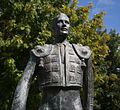
Statue of Manuel dos Santos in Golegã


Web links
- Map of the Freguesia Golegã at the Instituto Geográfico do Exército
- Official website of the city administration
- FNC-Feira Nacional do Cavalo , Portuguese
Individual evidence
- ↑ www.ine.pt - indicator resident population by place of residence and sex; Decennial in the database of the Instituto Nacional de Estatística
- ↑ a b Overview of code assignments from Freguesias on epp.eurostat.ec.europa.eu
- ↑ a b www.ine.pt - indicator resident population by place of residence and sex; Decennial in the database of the Instituto Nacional de Estatística
- ↑ www.verportugal.net , accessed on January 13, 2014
- ^ Hans-Peter Burmeister: Portugal. DuMont art travel guide . 3rd edition, DuMont Reiseverlag, Ostfildern 2008, p. 177
- ^ Page of the town twinning on the website of the town administration, accessed on January 14, 2014

Abrantes | Alcanena | Almeirim | Alpiarça | Benavente | Cartaxo | Chamusca | Constância | Coruche | Entroncamento | Ferreira do Zêzere | Golegã | Mação | Ourém | Rio Maior | Salvaterra de Magos | Santarém | Sardoal | Tomar | Torres Novas | Vila Nova da Barquinha
| ← Previous location: Santarém |
|
Next town: Fátima → |