Greene County, Alabama
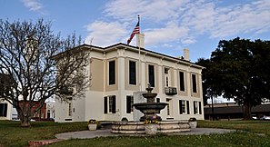
 Greene County Courthouse |
|
| administration | |
|---|---|
| US state : | Alabama |
| Administrative headquarters : | Eutaw |
| Address of the administrative headquarters: |
County Courthouse P.O. Box 656 Eutaw, AL 35462-0656 |
| Foundation : | December 13, 1819 |
| Area code : | 001 205 |
| Demographics | |
| Residents : | 9045 (2010) |
| Population density : | 5.4 inhabitants / km 2 |
| geography | |
| Total area : | 1709 km² |
| Water surface : | 36 km² |
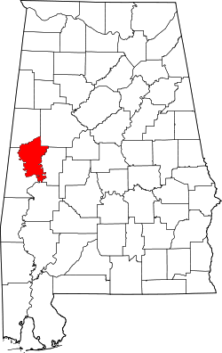
| map | |
| Website : greenecountyalabama.com | |
The Greene County is a county in the state of Alabama of the United States . The county seat is Eutaw .
geography
The county is located in western Alabama, about 25 km from Mississippi and has an area of 1,709 square kilometers, of which 36 square kilometers are water. The eastern border is formed by the Black Warrior River and the western border by the Tombigbee River . The county is bordered by counties in a clockwise direction: Tuscaloosa County , Hale County , Marengo County , Sumter County, and Pickens County .
history
Greene County was formed on December 13, 1819 from portions of the land cession by the Choctaw Indians on October 24, 1816. It was named after General Nathaniel Greene , who served as a general in the Continental Army during the American Revolutionary War from 1775 to 1780 . He was the presiding judge in the military tribunal that sentenced British officer John André to death. The first county capital was Erie, which is now in Hale County. In 1838 this became Eutaw. In 1868 the courthouse burned down and was completely destroyed.

35 structures and sites in the county are listed on the National Register of Historic Places (NRHP) as of April 2, 2020, including the First Presbyterian Church , the Greene County Courthouse and the Daniel R. Wright House .
traffic
About 10 km northwest of the district capital Eutaw, Interstate 20 and Interstate 59 run right through the county from northeast to southwest . US Highways 43 and 11 run through Eutaw itself . The Alabama State Routes 14 and 39 also run through the county.
Demographic data
| growth of population | |||
|---|---|---|---|
| Census | Residents | ± in% | |
| 1820 | 4554 | - | |
| 1830 | 15,026 | 230% | |
| 1840 | 24,024 | 59.9% | |
| 1850 | 31,441 | 30.9% | |
| 1860 | 30,859 | -1.9% | |
| 1870 | 18,399 | -40.4% | |
| 1880 | 21,931 | 19.2% | |
| 1890 | 22.007 | 0.3% | |
| 1900 | 24,182 | 9.9% | |
| 1910 | 22,717 | -6.1% | |
| 1920 | 18,133 | -20.2% | |
| 1930 | 19,745 | 8.9% | |
| 1940 | 19,185 | -2.8% | |
| 1950 | 16,482 | -14.1% | |
| 1960 | 13,600 | -17.5% | |
| 1970 | 10,650 | -21.7% | |
| 1980 | 11,021 | 3.5% | |
| 1990 | 10.153 | -7.9% | |
| 2000 | 9974 | -1.8% | |
| 2010 | 9045 | -9.3% | |
| Before 1900
1900–1990 2000 2010 |
|||

Greene County's population was 9,974 as of the 2000 census . 78 of them lived in collective accommodation, the other residents lived in 3931 households and 2649 families. The population density was 6 people per square kilometer. The racial the population was composed of 19.09 percent white, 80.34 percent African American, 0.12 percent Native American, 0.08 percent Asian and 0.10 percent from other ethnic groups; 0.27 percent were descended from two or more races. Hispanic or Latino of any race was 0.58 percent of the population.
Of the 3,931 households, 32.7 percent had children and adolescents under the age of 18 living with them. There were married couples living together in 36.4 percent, 27.1 percent were single mothers, 32.6 percent were not families, 30.8 percent of all households were single households and 12.3 percent had people aged 65 and over or above. The average household size was 2.52 and the average family size was 3.16.
29.2 percent of the population were under 18 years old, 8.9 percent between 18 and 24, 25.1 percent between 25 and 44, 22.1 percent between 45 and 64 and 14.7 percent were 65 years or older. The median age was 36 years. For every 100 females there were 88.4 males and for females aged 18 and over there were 79 males.
The median income for a household in the county is $ 19,819 , and the median income for a family is $ 24,604. Males had a median income of $ 25,707 versus $ 19,051 for females. The per capita income was $ 13,686. 29.9 percent of families and 34.3 percent of the population lived below the poverty line.
Places in Greene County
- Allison
- Birdeye
- Boligee
- Braggville
- Clinton
- Crawford Fork
- Eutaw
- Five points
- Forkland
- Fowler
- Gosa
- Guinea
- Hycutt
- Jackson Quarters
- Jena
- Knoxville
- Lewiston
- Lizzieville
- Mantua
- McClure
- Merriwether
- Miller
- Morrows Grove
- Mount Hebron
- New Mount Hebron
- New West Greene
- Pleasant Ridge
- Ridge
- Rosemont
- Snoddy
- Thornhill
- Tishabee
- union
- Walden Quarters
- West Greene
See also
literature
- Thomas McAdory Owen: History of Alabama and Dictionary of Alabama Biography. SJ Clarke Publishing Co., Chicago IL 1921.
- Virginia O. Foscue: Place Names in Alabama. University of Alabama Press, Tuscaloosa et al. 1989, ISBN 0-8173-0410-X .
Individual evidence
- ↑ GNIS-ID: 161557. Retrieved on February 22, 2011 (English).
- ↑ Greene County at Alabama.gov ( Memento of 13 March 2014 Internet Archive )
- ↑ Charles Curry Aiken, Joseph Nathan Kane: The American Counties: Origins of County Names, Dates of Creation, Area, and Population Data, 1950-2010 . 6th edition. Scarecrow Press, Lanham 2013, ISBN 978-0-8108-8762-6 , p. 120.
-
↑ Search mask database in the National Register Information System. National Park Service , accessed April 2, 2020.
Weekly List on the National Register Information System. National Park Service , accessed April 2, 2020. - ↑ US Census Bureau - Census of Population and Housing . Retrieved March 15, 2011
- ↑ Extract from Census.gov . Retrieved February 28, 2011
- ^ Population of Greene County - Alabama
- ↑ Extract from census.gov
- ^ Population of Greene County - Alabama
Web links
Coordinates: 32 ° 51 ′ N , 87 ° 57 ′ W

