
Haina (Nessetal)
|
Haina
Rural community of Nessetal
Coordinates: 50 ° 59 ′ 22 ″ N , 10 ° 31 ′ 4 ″ E
|
|
|---|---|
| Height : | 280 m |
| Area : | 6.72 km² |
| Residents : | 468 (Dec. 31, 2017) |
| Population density : | 70 inhabitants / km² |
| Incorporation : | 1st January 2019 |
| Postal code : | 99869 |
| Area code : | 036254 |
Haina is a district of the rural community Nessetal in the Thuringian district of Gotha .
geography
mountains
The landscape around Haina is shaped in the west by the breakthrough valley of the Nesse , here the Hintere Hainaer Holz appears to rise out of the surroundings like a mountain, the highest point is on the edge of the Kindel airfield ( 325 m above sea level )
Rivers
Haina is located in the middle section of the valley of the Nesse , into this river flow the Kirchbach and the Bieberbach with the Weidenbach tributary .
Neighboring communities
The neighboring communities of Haina were the community Hörselberg-Hainich in the Wartburg district with its districts Wenigenlupnitz, Wolfsbehringen and Behringen in the west and north, the community Friedrichswerth in the east and the districts Weingarten and Ebenheim (both community Hörsel ) in the south.
history
Early history
A traffic route that was important in prehistoric times leads from the Thuringian Basin past Haina into the Werra Valley. To control this military and trade route, the hill castles Schlösschen near Haina were built in the Hinteren Hainaer Holz as a barrier to the western entrance and the Hainaer castle on the outskirts of today's village as a barrier to the eastern entrance. Further fortifications were located within the locality, which underline the great importance of the place Haina in the Middle Ages. Important finds from several excavations are exhibited in the Museum of Regional History in Gotha.
First mention
In a deed of donation dated May 18, 874, Hago and other 116 places in Thuringia are mentioned as the Fulda Abbey. Archbishop Liubert zu Mainz as well as Abbot Sigehard zu Fulda asserted the right to raise the tithe for themselves. The dispute over this was decided by King Ludwig the German (840–876) at the court of Ingelheim in favor of the Fulda Abbey.
middle Ages
Haina was a capital of the Mark Lupnitz . Several important personalities of the empire stopped in the Haina administrative courtyard - a Palatinate-like street station - in transit. The market was first mentioned in 1273. From 1321 Haina belonged to the Lords of Wangenheim .
The Zollhof still exists in the village today . In the past, customs had to be paid there when passing the road to the municipality of Behringen. The window through which customs had to be passed still exists today. It was closed with glass stones as a souvenir. The Zollhof has been inhabited by the Allmrodt family since 1699.
Modern times
From 1640 Haina belonged as part of the Wangenheim court to the Duchy of Saxe-Gotha , from 1672 to Saxe-Gotha-Altenburg . In 1743 the place came to the Lords of Uechtritz (Fuga line). From 1826 Haina belonged to the Duchy of Saxe-Coburg and Gotha and from 1920 to the State of Thuringia .
On January 1, 2019, the previously independent communities of Haina, Ballstädt , Bufleben , Friedrichswerth , Goldbach , Hochheim , Remstädt , Wangenheim , Warza and Westhausen were merged to form the rural community of Nessetal . Goldbach was a member of the Mittleres Nessetal administrative association .
Population development
Development of the population (December 31) :
|
|
|
|
- Data source: Thuringian State Office for Statistics
Economy and Infrastructure
traffic
Road traffic
Haina is connected to the transport network via Landstrasse 1029. There is an unpaved connection path to Behringen, which you can also use to get to the Nessetal cycle path .
Rail transport
The nearest stop on the rail network is Mechterstädt . Until 2007, the siding, built in 1954, ran through the district from the Nessetalbahn to the former Kindel military training area .
air traffic
The Eisenach-Kindel airfield is located in the western part of the district .
Public transport
The bus line 820 of the regional transport association Gotha connects Haina with Gotha on weekdays . The nearest train station is Mechterstädt on the Thuringian Railway , about seven kilometers south of Haina.
Water and sewage
The water supply and wastewater disposal is ensured by the water and wastewater association Mittleres Nessetal.
Personalities
- Justus Friedrich Zachariae (born December 1, 1704 in Haina, † March 8, 1773 in Kiel ), writer
- Ernst Standhardt (born August 25, 1888 in Haina; † August 25, 1967 Estancia Fitz Roy in Argentina ), mountaineer and landscape photographer, after whom the 2739 m high Cerro Standhardt , belonging to the Argentine Andes , was named
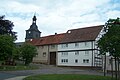
Attractions
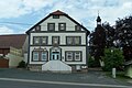
Tavern Zum Ritter
At the village square
In the local situation

The Hainaer wood

Town view from the south


Web links
literature
- Paul Grimm: Five prehistoric castles near Haina. In: Studies from Old Europe, Part II, Cologne-Gratz 1965.
Individual evidence
- ↑ a b c d Thuringian Land Survey Office TK25 - sheet 5029 Fröttstädt
- ↑ Hans Patze , Peter Aufgebauer (Ed.): Handbook of the historical sites of Germany . Volume 9: Thuringia (= Kröner's pocket edition . Volume 313). 2nd, improved and supplemented edition. Kröner, Stuttgart 1989, ISBN 3-520-31302-2 , pp. 181-182.
- ↑ Guido Reinhardt: History of the market Gräfentonna , Langensalza 1892.
- ↑ The German royal palaces . In: Michael Gockel (Ed.): Repertory of the Palatinate, royal courts and other places of residence of the kings in the German Empire of the Middle Ages . Thuringia. Vandenhoeck & Ruprecht, 1984, ISBN 3-525-36502-0 , pp. 179-195 .
- ↑ Thuringian Law and Ordinance Gazette No. 14/2018 , accessed on March 20, 2019
- ↑ Max Berbig: Zachariä, Just Friedrich . In: Allgemeine Deutsche Biographie (ADB). Volume 44, Duncker & Humblot, Leipzig 1898, p. 633 f.