
Geras
|
Borough Geras
|
||
|---|---|---|
| coat of arms | Austria map | |
 |
|
|
| Basic data | ||
| Country: | Austria | |
| State : | Lower Austria | |
| Political District : | horn | |
| License plate : | HO | |
| Surface: | 67.63 km² | |
| Coordinates : | 48 ° 48 ' N , 15 ° 40' E | |
| Height : | 460 m above sea level A. | |
| Residents : | 1,271 (January 1, 2020) | |
| Population density : | 19 inhabitants per km² | |
| Postcodes : | 2093, 3752, 3753 | |
| Area code : | 02912 | |
| Community code : | 3 11 07 | |
| NUTS region | AT124 | |
| UN / LOCODE | AT GRS | |
| Address of the municipal administration: |
Hauptstrasse 16 2093 Geras |
|
| Website: | ||
| politics | ||
| Mayor : | Johann Glück ( ÖVP ) | |
|
Municipal Council : ( 2020 ) (19 members) |
||
| Location of Geras in the Horn district | ||
  |
||
 Town hall Geras |
||
| Source: Municipal data from Statistics Austria | ||

Geras is a municipality with 1271 inhabitants (as of January 1, 2020) in the Horn district in Lower Austria .
geography
Geras is located in the northern Waldviertel in Lower Austria, north of Horn , which is 22 kilometers away by road. The area of the municipality covers 67.66 square kilometers. 35.21 percent of the area is forested.
Community structure
The municipality includes the following 12 localities (population in brackets as of January 1, 2020):
- Alone (138)
- Fugnitz (42)
- Geras (424) including the Geras Nature Park
- Goggitsch (135) including Steidlmühle
- Harth (71)
- Hoetzelsdorf (151)
- Kottaun (80)
- Pfaffenreith (20)
- Purgstall (40)
- Schirmannsreith (49)
- Sieghartsreith (76)
- Trautmannsdorf (45)
The community consists of the cadastral communities Dallein, Fugnitz, Geras, Goggitsch, Harth, Hötzelsdorf, Kottaun, Pfaffenreith, Purgstall, Schiermannsreith, Sieghartsreith, Thumeritzer Sasswald and Trautmannsdorf.
Several postcodes are used in the municipality of Geras. The main town Geras and the districts Fugnitz, Goggitsch, Kottaun, Pfaffenreith and Trautmannsdorf have the postcode 2093, the town Purgstall the postcode 3752, the remaining districts have the postcode 3753.
Neighboring communities
| Drosendorf-Zissersdorf | Langau | |
| Japons |
.svg)
|
Weitersfeld |
| Irnfritz knives | Pernegg | Sigmundsherberg |
history
The Premonstratensian- Chorherren- Stift Geras was founded in 1153 by Ekbert and Ulrich von Pernegg.
The Lower Austrian Landtag elevated the then market town to a town on September 26, 1928.
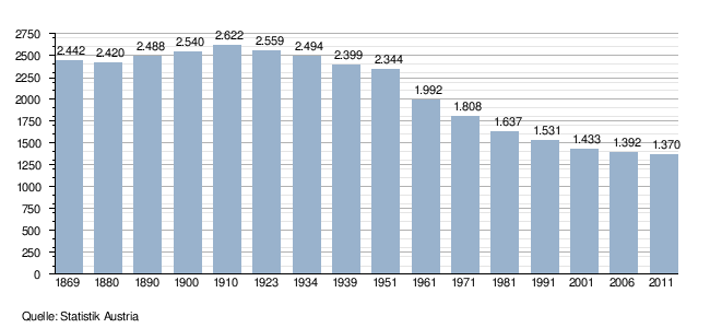
Population development
politics
The municipal council has 19 members.
- With the municipal council elections in Lower Austria in 1990, the municipal council had the following distribution: 15 ÖVP, 3 SPÖ, and 1 FPÖ.
- With the municipal elections in Lower Austria in 1995, the municipal council had the following distribution: 14 ÖVP, 3 SPÖ, 1 FPÖ, and 1 Neue Wahl Geras.
- With the municipal elections in Lower Austria in 2000, the municipal council had the following distribution: 15 ÖVP, 3 SPÖ, and 1 FPÖ.
- With the municipal council elections in Lower Austria in 2005 , the municipal council had the following distribution: 14 ÖVP, 4 SPÖ, and 1 alternative list.
- With the municipal council elections in Lower Austria in 2010 , the municipal council had the following distribution: 15 ÖVP and 4 SPÖ.
- With the municipal council elections in Lower Austria 2015 , the municipal council has the following distribution: 14 ÖVP, and 5 SPÖ.
- With the municipal council elections in Lower Austria 2020 , the municipal council has the following distribution: 16 ÖVP and 3 SPÖ.
- mayor
- ? -? Otto dirt
- since ? Johann Glück (ÖVP)
Culture and sights
.JPG)
- Geras Abbey
- Bulk hopper Geras
- Catholic parish church Harth hl. Rochus
- Geras Nature Park
- Potato Festival
economy
In 2001 there were 63 non-agricultural workplaces, agricultural and forestry businesses according to the 1999 survey 149. The number of people in work at home was 628 according to the 2001 census. In 2001 the activity rate was 45.21 percent. The most important companies in the municipality are the Geras Abbey, APV, a manufacturer of agricultural machinery, and the Hallenbau Baumhauer company in Dallein, as well as the Weiskircher joinery in Goggitsch.
traffic

- Train: The district of Hötzelsdorf is on the Franz-Josefs-Bahn . The ÖBB operate the Hötzelsdorf-Geras station .
- Bus: Lines 1255 ( Horn - Langau ) and 1304 (Horn- Drosendorf ) of the PostBus bus company go to stops in Geras and the districts.
- Street: Geras is on Horner Strasse (B4).
Personalities
- Joachim Angerer (1934–2019), Austro-German historian and musicologist, was abbot of Geras Abbey .
- Benedikt Reinhold Felsinger , OPraem (* 1965), Austrian clergyman, known as the “herb pastor”
- Hans Fischböck (1895–1967), Austrian lawyer, trade minister, general commissioner in the Netherlands, Reich commissioner, state secretary and SS brigade leader in the service of the Nazi regime, was born in Geras.
- Jakob Franz Alexander Kern (1897–1924), Austrian theologian and blessed of the Roman Catholic Church , was a Premonstratensian canon in the Geras Abbey .
- Ambros Josef Pfiffig (1910–1998), Austrian etrusologist, historian, local researcher and composer, was a Premonstratensian canon in the Geras Abbey .
- Michael Karl Proházka (* 1956) was the 57th abbot of Geras Abbey from 2007 to 2018 .
- František Ignác Tůma (1704–1774), Austrian court conductor, composer, was a Premonstratensian canon in the Geras Abbey .
- Honorary citizen Hermann-Josef Weidinger (1918–2004), Austrian Premonstratensian canon, known as a herb pastor
- Augustinus Karl Wucherer-Huldenfeld (* 1929), Austrian theologian and philosopher, is a Premonstratensian canon in the Geras Abbey .
- Alphons Žák (1868–1931), Austrian theologian, local researcher and historian, was a Premonstratensian canon in the Geras Abbey .
Web links
- Website of the municipality of Geras
- Entry about Schloss Goggitsch on NÖ-Burgen online - Institute for Reality Studies of the Middle Ages and Early Modern Times, University of Salzburg
- 31107 - Geras. Community data, Statistics Austria .
Individual evidence
- ↑ Statistics Austria: Population on January 1st, 2020 by locality (area status on January 1st, 2020) , ( CSV )
- ^ Result of the local council election 1995 in Geras. Office of the Lower Austrian State Government, March 30, 2000, accessed on August 11, 2019 .
- ^ Election result of the 2000 municipal council election in Geras. Office of the Lower Austrian State Government, February 4, 2005, accessed on August 11, 2019 .
- ^ Election result of the local council election 2005 in Geras. Office of the Lower Austrian State Government, March 4, 2005, accessed on August 11, 2019 .
- ^ Election result of the local council election 2010 in Geras. Office of the Lower Austrian State Government, October 8, 2010, accessed on August 11, 2019 .
- ^ Election results for the 2015 municipal council election in Geras. Office of the Lower Austrian State Government, December 1, 2015, accessed on August 11, 2019 .
- ↑ Results of the municipal council election 2020 in Geras. Office of the Lower Austrian State Government, January 26, 2020, accessed on February 20, 2020 .

Altenburg | Brunn an der Wild | Burgschleinitz-Kühnring | Drosendorf-Zissersdorf | Eggenburg | Gars am Kamp | Geras | Horn | Irnfritz knives | Japons | Langau | Meiseldorf | Pernegg | Röhrenbach | Röschitz | Rosenburg-Mold | Sigmundsherberg | St. Bernhard-Frauenhofen | Straning-Grafenberg | Weitersfeld