Haselbrunn (Plauen)
|
Haselbrunn
City of Plauen
Coordinates: 50 ° 30 ′ 54 ″ N , 12 ° 7 ′ 48 ″ E
|
|
|---|---|
| Area : | 5.04 km² |
| Residents : | 4361 (May 9, 2011) |
| Population density : | 865 inhabitants / km² |
| Incorporation : | January 1, 1899 |
| Postal code : | 08525 |
| Area code : | 03741 |
|
Location of Haselbrunn in Plauen
|
|
Haselbrunn is a district in the northern urban area of Plauen .
geography
Haselbrunn is located in the north of Plauen and borders on eight other districts of Plauen.
| Joessnitz | Reissigwald with a hole house | |
| Kauschwitz |

|
Cracked |
| Syratal | Station suburb | Torn suburb |
The area of the district consists of 17.2% agricultural land and 44.3% forest . The remaining area is streets, residential and industrial areas.
The Pietzschebach rises in the north of the district and flows through the northwestern part of Haselbrunn and later flows into the White Elster .
history
The place was mentioned in 1418 as Haselbrun . It was a square village in a block corridor . On March 14, 1611, the city council bought the Haselbrunn estate from the bankruptcy of the electoral locksmith Nocolas Wenigel for 1,050 guilders. The Rehnsberg (Rähnisberg), the Heidenreich, the Erbholz as well as Kembler ( Kemmler ) and Glockenberg were bought for a further 1,800 guilders . On August 21, 1613, the council was able to purchase the remaining Haselbrunn properties from the bankruptcy estate for 2500 guilders. The Haselbrunn Vorwerk was sold until 1829 to pay the town's war debts. Haselbrunn belonged to the Plauen office until the 19th century . On September 6, 1898, the city council unanimously decided to incorporate Haselbrunn. This came into force on January 1, 1899.
Development of the population
|
|
Culture and sights

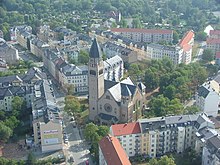
The landmark of the district is the Markuskirche , which was built from 1910 to 1913. It is a neo-Byzantine building that was designed by architect Heinrich Adam and carried out under the direction of the city planning officer Wilhelm Goette . During the Second World War, the church was damaged by an air raid and gradually repaired in the post-war years. From 1965 to 1967 the church hall was divided at the level of the galleries and an upper and a lower church hall and various parish rooms were created. In 2003 the upper hall was renovated, whereby the old painting from 1913 was exposed again.

The Vogtlandstadion is a football stadium with an athletics facility and home of VFC Plauen . It is located in the northern part of Haselbrunn, near the city forest, and is the city's largest open-air sports area. A tartan track runs around the grass pitch where, among other things, the football matches of the first team take place. This is surrounded by the spectator area, which currently has a capacity of 16,400 seats. There are around 5,000 seats on three grandstands and around 12,000 standing places in the rest of the area. There is also a hard court, a natural grass field and an artificial grass field on the training site. On March 3, 2011, the inner part of the stadium with the soccer field was renamed the Sternquell Arena.
Opposite the stadium is the Haselbrunn outdoor pool, one of the city's two outdoor pools.
Economy and Infrastructure
traffic
The railway loop of the Leipzig – Hof railway line , which surrounds Haselbrunn, is characteristic. This belongs to the Sachsen-Franken-Magistrale . In the western part of the federal highway 92 runs in a north-south direction through Haselbrunn. On May 17, 1902, Haselbrunn was connected to the tram network. In the following years the route was continuously extended.
Established businesses
In the north-west of the district is the site of Plamag Plauen , a printing press manufacturer that was the city's largest employer between 2011 and 2012 until its gradual insolvency. The site is now being marketed as an industrial park.
literature
- Rudolf Laser: Plauen-Haselbrunn 1925–1934 . Experienced and experienced. Vogtland-Verlag, Plauen 2003, ISBN 978-3-928828-27-7 .
Web links
- Haselbrunn in the Digital Historical Directory of Saxony
Individual evidence
- ↑ Area of the district in the 9th Official Statistics Report 2014, Chapter 3.01. (PDF) Retrieved February 10, 2016 .
- ↑ a b Population of the district in the 9th Official Statistics Report 2014, Chapter 5.02. (PDF) Retrieved February 10, 2016 .
- ↑ a b Gerd Kramer: Stadtentwicklung Plauen , pp. 64–65 in: Brigitte Unger, Werner Pöllmann u. a. (Ed.): The Vogtland Atlas. Regional atlas on nature, history, population, economy and culture of the Saxon Vogtland . 3. Edition. Verlag Klaus Gumnior, Chemnitz 2007, ISBN 978-3-937386-18-8
- ↑ Historical place directory of Saxony
- ↑ A. Neupert sen. (Ed.): Small Chronicle of the City of Plauen i. Vogtland from 1122 until the end of the 19th century . Commission publisher Rud. Neupert jr., Plauen 1909, ISBN 978-3-929039-23-8 .
- ↑ Haselbrunn's population up to 1890 in the Digital Historical Directory. Retrieved February 19, 2015 .
- ↑ Page of the Plamag Plauen industrial park. Retrieved March 5, 2013 .

