Havířov
| Havířov | ||||
|---|---|---|---|---|
|
||||
| Basic data | ||||
| State : |
|
|||
| Region : | Moravskoslezský kraj | |||
| District : | Karviná | |||
| Area : | 3207 ha | |||
| Geographic location : | 49 ° 47 ' N , 18 ° 26' E | |||
| Height: | 260 m nm | |||
| Residents : | 71.903 (Jan. 1, 2019) | |||
| Postal code : | 736 01 | |||
| traffic | ||||
| Railway connection: | Český Těšín – Polanka nad Odrou | |||
| structure | ||||
| Status: | Statutory city | |||
| Districts: | 8th | |||
| administration | ||||
| Mayor : | Jana Feberová (as of 2016) | |||
| Address: | Svornosti 2 736 01 Havířov |
|||
| Municipality number: | 555088 | |||
| Website : | www.havirov-city.cz | |||
Havířov (Polish Hawierzów ) is a medium- sized town in Moravskoslezský kraj in the Czech Republic . It was created in 1955 and is located in the Moravian-Silesian industrial area (Ostravsko-Karvinsko).
geography
Havířov is located at the confluence of the Sušanka in the Lučina . In the north it borders on the mining regions Petřvald , Orlová and Karviná , in the west on the municipalities of Šenov and Václavovice . The landscape is slightly hilly and intersected with stream and river valleys. From west to east the landscape crosses the railway connection and the Ostrava - Svinov road to Český Těšín. A densely populated residential area runs along the trunk road.
history
Historical sources mention Horní and Dolní Suchá in the Liber fundationis episcopatus Vratislaviensis around 1305 , as well as probably the neighboring Šenov (Schonwald / Schönhof). The first reliable evidence of the existence of the Bludovice village comes from 1335. In 1438, Šumbark is mentioned for the first time . In the middle of the 16th century, Šumbark was referred to as a city, but it is not proven that Šumbark actually used city rights.
The communities that were later incorporated into Havířov were mostly Polish-speaking according to the censuses from 1880 to 1910, which became the basis of the Polish claim after the First World War (see Olsa area ).
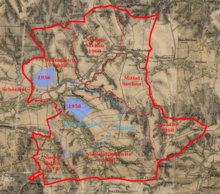
The emergence of the town of Havířov is related to the development of mining settlements in the territory of the municipalities of Šumbark and Dolní Bludovice, including parts of the Šenov corridors. The settlement was elevated to the status of a town by a government decision on December 4, 1955, initially on an area of 344 hectares, 230 from Dolní Bludovice, 53 from Šumbark and 61 from Šenov. The name of the city was chosen in a public competition. The candidates were u. a. Bezručov , Gottwaldův Hornikov , Stalin , Budosociokolektivov . Havíř (derived from the German ' Hauer ') means in Czech: miner, as well as hawiyrz in the Teschen dialects . Havířov has a reputation as a city with high quality residential areas and, compared with other cities in the region, a clean environment and good opportunities for recreation.
After the coal works were closed, the number of residents fell noticeably.
From 1998 the city belongs to the Euroregion Cieszyn Silesia as the largest city on the Czech side. In the city there is a Czech-German meeting center, as well as the seat of the Association of Germans of Teschner Silesia. According to the 2011 census, the city was inhabited by Poles (2.5%) in 1906, the fourth largest number in the Olsa area. 18,396 (24%) people did not state any nationality, more than in all other places in the Euroregion.
Districts
- Město ( city )
- Šumbark ( Schumbarg , also Schumberg, Schomberg , originally Schönberg )
- Podlesí ( Podleiss , also Podles )
- Životice ( Ziwotitz )
- Bludovice ( Bludowitz , older Bluda (1335), Blawde , Nieder Bludowitz )
- Prostřední Suchá ( Mitteluchau older also Sucha , Suche , Durche (1447))
- Dolní Suchá ( Niedersuchau )
- Dolní Datyně ( Niederdatein , also Niederdattin )
Attractions
- Šumbark Castle
Personalities
- born in Havířov
- Franz Pacher (1919–2018), Austrian civil engineer
- Radim Cepek (* 1975), floorball player
- Pavel Šnobel (* 1980), tennis player
- Robert Mayer (* 1989), Czech-Swiss ice hockey player
- Pavel Maslák (* 1991), track and field athlete
- David Pastrňák (* 1996), ice hockey player
- worked in Havířov
- Miroslav Baranek (* 1973), football player who started his career here
Twin cities
- Mažeikiai , Lithuania
- Harlow , UK
- Collegno , Italy
- Jastrzębie-Zdrój , Poland
Web links
- City website (CZ / EN / DE / PL)
Individual evidence
- ↑ Český statistický úřad - The population of the Czech municipalities as of January 1, 2019 (PDF; 7.4 MiB)
- ^ Association of Germans of Teschner Silesia
- ↑ Janusz Józef Węc (ed.): Wpływ integracji europejskiej na przemiany kulturowe i rozwój społeczno-gospodarczy Euroregionu "Śląsk Cieszyński" . Księgarnia Akademicka, Kraków – Bielsko-Biała 2012, ISBN 978-83-7638-293-7 , p. 88–93 (Polish, Czech).
- ↑ Spis powszechny 2011 (Polish)
- ↑ a b c d e Hosák, Ladislav - Šrámek, Rudolf: Místní jména na Moravě a ve Slezsku I-II. Prague
- ↑ Durche refers here to the word meaning of Sucha translated into German, namely drought.


