
Allmersbach in the valley
| coat of arms | Germany map | |
|---|---|---|

|
Coordinates: 48 ° 54 ' N , 9 ° 28' E |
|
| Basic data | ||
| State : | Baden-Württemberg | |
| Administrative region : | Stuttgart | |
| County : | Rems-Murr district | |
| Height : | 286 m above sea level NHN | |
| Area : | 7.96 km 2 | |
| Residents: | 4840 (December 31, 2018) | |
| Population density : | 608 inhabitants per km 2 | |
| Postal code : | 71573 | |
| Area code : | 07191 | |
| License plate : | WN, BK | |
| Community key : | 08 1 19 003 | |
| LOCODE : | DE 7AA | |
| Address of the municipal administration: |
Backnanger Strasse 42 71573 Allmersbach im Tal |
|
| Website : | ||
| Mayor : | Ralf Woerner | |
| Location of the community of Allmersbach in the valley in the Rems-Murr district | ||
  |
||


Allmersbach im Tal is a municipality in the Rems-Murr district in Baden-Württemberg . It belongs to the Stuttgart region (until 1992 the Middle Neckar region ) and the peripheral zone of the European metropolitan region of Stuttgart .
geography
Geographical location
Allmersbach im Tal lies east of Stuttgart on the edge of the Swabian Forest in the Backnanger Bay at 285 to 315 m above sea level. NN height.
Community structure
The community of Allmersbach im Tal consists of the two villages Allmersbach im Tal and Heutensbach. In the district of Allmersbach in the valley lies the Vogtsweiler desert .
Division of space

According to data from the State Statistical Office , as of 2014.
history
Allmersbach im Tal was first mentioned in 1291 in connection with a donation of some goods from Countess Richinza von Löwenstein to the Winnenden Order of the Teutonic Order . As a result of this donation, the local rule came to the Dominican convent Weiler near Esslingen . In the 16th century, local rule passed to Württemberg as a result of the Reformation . Allmersbach im Tal belonged to the cloister master's office until 1712 and to the monastery administration of the Weiler monastery near Esslingen until 1807. With the implementation of the new administrative structure in the Kingdom of Württemberg , Allmersbach im Tal was assigned to the Oberamt Backnang in 1807 . During the district reform during the Nazi era in Württemberg , Allmersbach in the valley came to the Backnang district in 1938 . In 1945 the place became part of the American zone of occupation and thus belonged to the newly founded state of Württemberg-Baden , which was incorporated into the current state of Baden-Württemberg in 1952.
On January 1, 1972, Heutensbach was incorporated into Allmersbach im Tal.
Due to the district reform in Baden-Württemberg , Allmersbach im Tal became part of the Rems-Murr district on January 1, 1973 .
politics
mayor
- 1975–1999: Rüdiger Kieninger
- since 1999: Ralf Wörner
Municipal council
The municipal council in Allmersbach im Tal has 14 members. The municipal council consists of the elected voluntary councilors and the mayor as chairman. The mayor is entitled to vote in the municipal council. The local elections on May 26, 2019 led to the following final result:
| Parties and constituencies |
% 2019 |
Seats 2019 |
% 2014 |
Seats 2014 |
||
| UWV | Independent electoral association | 53.24 | 7th | 55.23 | 8th | |
| NLAH | New list Allmersbach / Heutensbach | 46.76 | 7th | 44.77 | 6th | |
| total | 100.0 | 14th | 100.0 | 14th | ||
| voter turnout | 60.63% | 51.33% | ||||
Economy and Infrastructure
Resident companies
Antenna measuring station
The Ericsson company (from 1903 to 1954 Telefunken , 1955 to 1982 AEG , 1983 to 1995 ANT Telecommunications, 1996 to 1999 Bosch Telecom, 2000 to 2006 Marconi Corporation plc ) operates an antenna test station in Allmersbach im Tal . There are three antenna supports at 48 ° 54 ′ 45 ″ N , 9 ° 27 ′ 49 ″ E , at 48 ° 54 ′ 36 ″ N , 9 ° 27 ′ 32 ″ E and at 48 ° 54 ′ 51 ″ N , 9 ° 27 '41 " O .
Pictures from Allmersbach im Tal


Aerial view of Allmersbach
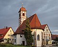
Gothic church in the town center

town hall

Antenna measuring station


Personalities
- Arik Braun (* 1988), chess player
Individual evidence
- ↑ State Statistical Office Baden-Württemberg - Population by nationality and gender on December 31, 2018 (CSV file) ( help on this ).
- ^ The state of Baden-Württemberg. Official description by district and municipality. Volume III: Stuttgart District, Middle Neckar Regional Association. Kohlhammer, Stuttgart 1978, ISBN 3-17-004758-2 , pp. 502-503.
- ↑ State Statistical Office, area since 1988 according to actual use for Allmersbach im Tal.
- ^ Federal Statistical Office (ed.): Historical municipality directory for the Federal Republic of Germany. Name, border and key number changes in municipalities, counties and administrative districts from May 27, 1970 to December 31, 1982 . W. Kohlhammer, Stuttgart / Mainz 1983, ISBN 3-17-003263-1 , p. 446 .
- ^ Election information from the Stuttgart municipal data center .
Web links

Alfdorf | Allmersbach im Tal | Althütte | Aspach | Floodplain forest | Backnang | Berglen | Burgstetten | Fellbach | Großerlach | Kaisersbach | Kernels in the Remstal | Kirchberg an der Murr | Basket | People Bach | Murrhardt | Oppenweiler | Plüderhausen | Remshalden | Rudersberg | Schorndorf | Schwaikheim | Spiegelberg | Sulzbach an der Murr | Urbach | Waiblingen | Weinstadt | Weissach im Tal | Welzheim | Winnenden | Winterbach