
Hochwald (Zittau Mountains)
| Hochwald / Hvozd | ||
|---|---|---|
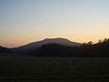
 Looking for Hochwald by Mařenice from |
||
| height | 749.5 m above sea level NHN | |
| location | Saxony border ( Germany - Czech Republic ) | |
| Mountains | Lausitz - Zittau Mountains | |
| Coordinates | 50 ° 49 '21 " N , 14 ° 43' 34" E | |
|
||
| Type | Kegelberg | |
| rock | Phonolite breakthrough in sandstone | |
| particularities | Hochwaldturm ( AT ) | |


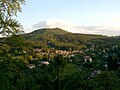
The high forest (Czech. Hvozd ) is 749.5 m above sea level. NHN one of the highest mountains in the Lusatian / Zittau Mountains directly on the German-Czech border about 2.5 km southwest of the health resort Oybin and 2 km east of Krompach . The broad saddle-shaped shape is striking. It has two peaks, the southern main summit, over which the state border between Germany and the Czech Republic runs, and the 743.8 m above sea level. NHN high northern summit, 370 m away. Because of its good view, the mountain is also known as the observation tower of the Zittau Mountains .
Summit area
South summit
In 1853 the first “Bohemian” hut was built on the Bohemian side of the south summit, but in 1877 it burned down completely. In the next year a new half-timbered mining house was built, and a year later the 10 m high Carola tower (a wooden observation tower ). Because of the large number of visitors, a second restaurant with guest rooms was built on the Saxon side of the southern tip, which still exists today as a "Saxon" Bergbaude ( Hochwaldbaude ). The “Bohemian” hut was demolished until 1951 after the end of the Second World War .
North summit
As the wooden lookout tower soon became dilapidated, the decision was made to build a new, 25 m high stone lookout tower, which, however, was built on the north summit for reasons of space. The old Carola tower was demolished in 1891, and the new Hochwald tower was inaugurated on September 14, 1892 by Oskar Friedrich , chairman of the Globus mountain association responsible for its construction . A short time later, a ticket booth was built next to the tower, which eventually became another restaurant, today's Hochwald tower building , where New Year's Eve celebrations are also held.
view
From the upper terrace of the Hochwaldbaude there is an undisturbed view to the east, south and west. The phonolite dome of the Sokol ( Falkenberg ) and the Jezevčí vrch ( Limberg ) rises nearby . With good visibility conditions, a distant view of the Jizera and Giant Mountains , the Jeschken , the mountains of the Lusatian Mountains as well as Saxon Switzerland , northern Bohemia and the eastern Ore Mountains are possible.
From the Hochwaldturm on the north summit, the view extends over the mountains of the Zittau Mountains with Töpfer , Scharfenstein , Berg Oybin , Ameisenberg and to Lausche .
From the high forest, from east to south to northeast, the following mountains, cliffs, castles, places, etc. are visible: Popova skála , Jizera Mountains with Smrk , Grabštejn , Giant Mountains with Frost Bearers , Vysoké kolo , Schneekoppe , Ještěd , Trosky castle ruins , Vyskeř in the region Bohemian Paradise , castle Lemberk , Ralsko , Bezděz , Rip , Sedlo , Milešovka , Buková with striking TV tower, Klíč , Děčínský Sněžník Studenec , Saxon Switzerland , Pěnkavčí vrch , Harken , Tanečnice , Hrazený , Valtenberg , Keulenberg , Czorneboh , Kottmar , Löbauer Berg , Rotstein , Königshainer Berge , Landeskrone , Zittauer Gebirge with Oybin , Zittau .
Paths to the summit
- A large number of marked hiking trails lead to the high forest. Good starting points for a visit to the mountain are the places Oybin, Hain , Petrovice and Krompach , but also the hiking car park at the Kammloch .
- The historical Kammweg as the European long-distance hiking trail E3 , the long-distance hiking trail Zittau – Wernigerode and the Oberlausitzer Bergweg lead across the high forest .
- In summer, the high forest is approached daily by a tourist shuttle train.
View from the mountain Oybin to the high forest
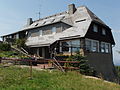
Hochwaldbaude

Tower building in winter
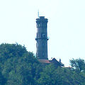
The observation tower
View from Petersdorf

View from the horse mountain
View from the Lückendorf forester's house


.JPG)
.JPG)

literature
- Alfred Moschkau : The Carolathurm on the Hochwalde near Zittau . Zittau around 1879 ( digitized version )
- Peter Rölke (Ed.): Hiking and nature guide Zittauer Gebirge, Berg- und Naturverlag Rölke, Dresden 2006
Web links
- Hochwaldbaude
- Hochwald tower building
- Interactive 360 degree panorama from the observation tower on the high forest
Individual evidence
- ↑ Map services of the Federal Agency for Nature Conservation ( information )
- ↑ a b Topographic map 1: 10,000. In: Protected areas in Germany - Map service of the Federal Agency for Nature Conservation. Retrieved December 10, 2014 .
- ^ Hochwald / Hvozd on the Czech website Lausitzer Gebirge
- ^ Ingrid Seltmann: Famous personalities of Upper Lusatia . tape 1 . Oberlausitzer Verlag, Spitzkunnersdorf 2009, ISBN 978-3-933827-81-4 , p. 79 f .