Hoh Xil
| Hoh Xil | |
|---|---|
|
UNESCO world heritage |
|

|
|
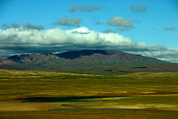
| Hoh Xil plateau in August |
|
| National territory: | China |
| Type: | nature |
| Criteria : | (vii) (x) |
| Surface: | 3,735,632 ha |
| Buffer zone: | 2,290,904 ha |
| Reference No .: | 1540 |
| UNESCO region : | Asia and Pacific |
| History of enrollment | |
| Enrollment: | 2017 ( session 41 ) |
| Tibetan name |
|---|
|
Tibetan script :
ཧོ་ ཧོ་ ཞི་ ལི
ཨ་ ཆེན་ གངས་ རྒྱལ |
|
Wylie transliteration : ho ho zhi li
a chen gangs rgyal |
|
Pronunciation in IPA : [
hohoɕili
atɕẽkaŋcɛː ] |
|
Official transcription of the PRCh : Hohoxili
Aqênganggyai |
|
THDL transcription : Hohoshili
Achenganggyel |
|
Other spellings: -
|
| Chinese name |
|
Traditional :
可可西里
阿 卿 貢嘉 |
|
Simplified :
可可西里
阿 卿 贡嘉 |
|
Pinyin : Kěkěxīlǐ
Āqīnggòngjiā |
Hoh Xil ( Mongolian : köke sil ᠬᠥᠬᠡ
ᠰᠢᠯ) is a remote region in the northwest of the Qinghai - Tibet highlands. It is the most populous region in China . The region has been a UNESCO World Heritage Site since 2017 .
description
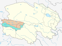
Hoh Xil belongs in the broader sense to the highlands of Tibet and lies between the Kunlun Mountains and the Dangla Mountains on the border between Qinghai and Tibet and Xinjiang in the Zhidoi (治 多 县) and Zadoi (杂 多 县) districts of the Yushu Autonomous District the Tibetan . The region is characterized by a high concentration of lakes. The region, declared a World Heritage Site, covers 37,356.32 km² and an additional 22,909.04 km², which serve as a buffer zone, and is over 4500 m high. It is the catchment area of the Yangtze and was declared a national nature reserve in 1995 . The Qinghai-Tibet Railway runs in the eastern section of the area. A narrow corridor around most of the railway line is excluded from the narrower protected area and belongs to the buffer zone.
In Hoh Xil there is a cold high mountain climate with an annual average temperature of –4.0 ° C to –9.0 ° C. The lowest temperatures measured here were -45 ° C. The precipitation falls mainly in the summer months. Despite the extreme geographic and climatic conditions, over 230 species of wild animals can be found in Hoh Xil, 20 of which are protected, including the Tibetan antelope . The geographical conditions have favored the formation of a very unique flora and fauna. Over a third of the plant species found on the plateau and around 60% of the mammalian species are endemic here. Due to the harsh climatic conditions, the plateau has remained largely free of human interference. Extensive migrations of tens of thousands of Tibetan antelopes to the plateau take place every early summer. The herds come from the Altun Mountains in the north, the Changthang in the west and the Sanjiangyuan in the east. Fighting poachers in Hoh Xil is the subject of the 2004 Chinese film Kekexili - Mountain Patrol .
World natural heritage
In 2017, the region was included in the UNESCO World Heritage List under the name “Qinghai Hoh Xil” as a natural heritage site. In the summary of the Executive Committee, UNESCO states the following two criteria: 1) the area is of exceptional aesthetic beauty with a history of almost 300 million years, which illustrates the geomorphological change, 2) the area contains significant habitats for the conservation of biodiversity and be home to numerous endemic and threatened animal and plant species such as B. the Tibetan antelope.
literature
- Lǐ Bǐngyuán 李炳 元, Qīnghǎi Kěkěxīlǐ dìqū zìrán huánjìng青海 可可西里 地区 自然环境, Beijing, Kēxué chūbǎnshè 科学 出版社 1996, ISBN 7-03-005562-4 .
- Cáigā 才嘎, Qīnghǎi Kěkěxīlǐ guójiājí zìrán bǎohùqū 10 nián zhàndòu lìchéng青海 可可西里 国家级 自然保护区 10 年 战斗 历程, Xining, Qīnghǎi rénmín chūbǎnshè 青海 人民出版社 2006, ISBN 7-225-02852-9 .
- Matsumoto Otto 松本 夫, Harukanari bikyō Kokoshiri Konron o koete遥 か な り 秘境 可可西里 崑崙 を 越 え て, Tokyo, Nihon hōsō shuppan kyōkai 日本 放送 出版 協会 1999, ISBN 4-14-080465-3 .
Web links
- Chronology of the environmental protection efforts in Hoh Xil (China Internet Information Center, September 8, 2006)
- Kekexili Features ( enorth.com.cn ; in English)
- Kekexili ( IMDb ; in English)
Individual evidence
- ↑ a b c UNESCO World Heritage Center: Qinghai Hoh Xil. Retrieved August 1, 2017 .

