
Hungerburg
|
Hungerburg Statistical district |
|
|---|---|
 |
|
| Basic data | |
| Pole. District , state | Innsbruck city (I), Tyrol |
| Judicial district | Innsbruck (city) |
| Pole. local community | Innsbruck ( KG Hötting , Mühlau ) |
| Locality | Hötting , Mühlau |
| Coordinates | 47 ° 17 '10 " N , 11 ° 23' 49" E |
| height | 868 m above sea level A. |
| Residents of the stat. An H. | 1005 (2014) |
| Building status | 435 (2014) |
| surface | 31.83 km² |
| Post Code | 6020 Innsbruck |
| Primaries | + 43 / (0) 512 (Innsbruck) |
| Official website | |
| Statistical identification | |
| Statistical district | 12 Hungerburg |
| Counting district / district | Hungerburg-Hötting, Hungerburg-Mühlau (70101 X [31,41]) |
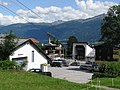
 View from Saggen to the Hungerburg |
|
| Source: STAT : index of places ; BEV : GEONAM ; TIRIS ; City of Innsbruck: Statistics - Numbers | |
The Hungerburg , also called Hoch-Innsbruck , is a district of the provincial capital Innsbruck of the state of Tyrol in Austria .
geography
The Hungerburg is located north of the city center , at an altitude of 860 m above sea level. A. , on a high plateau at the foot of the Nordkette under the Hafelekar ( 2334 m above sea level ).
- Neighboring districts
.svg)
|
Arzl Mühlau |
|
| Hötting West | Hötting |
structure
The Hungerburg belongs to two cadastral communities or localities . The much larger part belongs to Hötting , a small strip in the east to Mühlau . In addition to the Hungerburg settlement itself, the area also includes Gramartboden and the mountainous areas on the Hafelekar.
history


Until about 1840 the Hungerburg terrace formed a fairly closed forest area, the western area of which belonged to Hötting and the eastern area to Arzl and after 1740 to the municipality of Mühlau . The corridor on the gray stone was named after the Höttinger Breccie bank , which is open here.
Joseph Andreas von Attlmayr, the husband of Maria von Wörndle zu Weiherburg, bought a piece of the Gramart forest in 1840, just on the Höttingen municipality border towards Mühlau. In 1840 he had a well dug here and a summer house built, which he named Neuhof Mariabrunn . The offer of the associated snack station was apparently meager, which soon earned it the nickname Hungerburg in the vernacular . This name was carried over to the terrace settlement developed here from 1906 onwards. The Innsbruck tourism pioneer Sebastian Kandler tried around 1900 to develop the Hungerburg into a summer resort.
The first Hungerburgbahn , a funicular to the Hungerburg, was built in 1905/06. The cable car from the Hungerburg to the Nordkette , to the Seegrube and to the Hafelekar - Nordkettenbahn - was built in 1927/28.
The Seehof facilities were opened in 1912. In a former quarry, the Hungerburgsee was created as a bathing lake, which was fed by a waterfall. The Gasthaus Seehof was located on the shore, and above the lake there was an observation tower that was reached by a boat trip across the lake, access through a rock cave on the lake shore and a lift to the tower gate. The First World War and the subsequent economic crisis meant the end for the plant. It was handed over to the Kinderfreunde in 1926 , who used it as a rest home. The Chamber of Labor has been running the Seehof as an education center since 1951 .
From 1928 onwards, Rudolf Schlenz sen. and Dominikus Dietrich OPraem, prior in Wilten Abbey , set up a parish, initially with the former Würth garden house as an emergency church. The Theresienkirche was built in 1931/32 . The Austrian artist Max Weiler was commissioned to design the church in 1946/47. His fresco caused a scandal among the population and the church because of the depiction of a Tyrolean rifle captain's lance stabbing into the heart of Jesus, so that it had to be imposed for years.
In 1938 the two communities of Hötting and Mühlau were incorporated into Innsbruck, and since then Hungerburg has increasingly developed into an independent district.
The old Hungerburgbahn was replaced on December 1, 2007 by today's Hungerburgbahn with a different route.

Theresienkirche

former Café zur Linde, now kindergarten

Lookout tower of the Seehof
Valley station of the Nordkettenbahn


coat of arms

Since only municipalities are authorized to do so in Tyrol, the Hungerburg does not have an official coat of arms. As for the other districts of Innsbruck, an unofficial coat of arms was designed, which was adopted by the Hungerburg Interest Group in 1995. It shows in a four-part shield in the top right and bottom left field in green three silver arches of the diagonally rising viaduct of the Hungerburgbahn, in the top left field in red a silver mill wheel (the district coat of arms of Mühlau) and in the bottom right field in red the stylized tower the old Hötting church (the district coat of arms of Hötting).
The coat of arms reminds that the development of the district is inextricably linked with the construction of the Hungerburgbahn and refers to the affiliation to the two former communities and today's cadastral communities Hötting and Mühlau.
literature
- Franz-Heinz Hye : "From Grauenstain" to Hungerburg - History of the Hoch-Innsbruck district . Innsbruck 1982.
- Herbert Woditschka: On the history of the Hungerburg. In: Innsbrucker Stadtnachrichten, No. 7/1987, p. 24 ( digitized version )
Web links
- Homepage of the district of Hoch-Innsbruck / Hungerburg
- Hungerburg , in the history database ofthe association "fontes historiae - sources of history"
- History of the Hungerburg , hungerburg.at - after Lit. Hye 1982, with illustrations
proof
- ↑ The Hungerburgsee facility. Retrieved April 10, 2019 .
- ^ History of the Theresienkirche ( memento from April 2, 2015 in the Internet Archive ), hungerburg.at
- ^ Franz-Heinz Hye: The Hungerburg - Hoch-Innsbruck also received its own coat of arms for the district. In: Innsbruck informs, February 1996, p. 22 ( digitized version )

Cadastral communities, localities and districts: Amras | Arzl | Hötting | Igls | Innsbruck | Mühlau | Pradl | Vill | Wilten
Statistical districts: city center | Mariahilf-St. Nicholas | Dreiheiligen slaughterhouse | Saggen | Wilten | Sieglanger-Mentlberg | Pradl | Reichenau | Hötting | Höttinger Au | Hötting West | Hungerburg | Mühlau | Industrial area Mühlau / Arzl | Arzl | Olympic Village | Amras | Commercial area Roßau | Vill | Igls
City districts (settlement identification) :
Amras •
Arzl •
Hötting •
Innsbruck •
Mühlau •
Olympic village •
Pradl •
Wilten
villages:
Igls •
Vill |
Rotten:
Finkenberg •
Untere Figge |
Settlements:
Allerheiligenhöfe •
Egerdach •
Hungerburg-Hötting •
Hungerburg-Mühlau •
Kranebitten •
Mentlbergsiedlung •
Sieglanger •
Sadrach |
Groups of houses:
Alpenzoo •
Mount of Olives |
Other locations:
Ambras Castle •
Arzler Alm •
Innsbruck Airport •
Gluirschhöfe •
Grillhof •
Gramartboden •
Hafelekar mountain station •
Handlhof •
Harterhof •
Holy Year settlement •
Heiligwasser •
Hohenburg Castle •
Hörtnagl settlement •
Höttinger Alm •
Höttinger Bild •
Lohbach settlement •
Mariahilf •
Mentlberg Castle •
Mentlbergsiedlung •
Möslalm •
Neuarzl •
Peerhofsiedlung •
Pfeishütte •
Planötzenhof •
Roßau •
St. Nikolaus •
Seegrube station •
Taxburg Castle •
Tivoli •
Zenzenhof
Counting districts: Old Town | Left bank of the Inn | Inner City North | Inner City-West | Inner City East | Holy Trinity | Saggen-West | Saggen-North | Saggen-East | Wilten-Ost | Wilten-Mitte | Wilten-South | Wilten-West | Sieglanger | Mentlberg | Pradl-North | Pradl-Mitte-West | Pradl-Middle-East | Pradl-South | Pradl-East | Reichenau-West | Reichenau-East | Hötting center | Hungerburg-Hötting | Höttinger Au-Ost | Höttinger Au-West | Lohbach settlement | Hörtnaglsiedlung | Hötting-West | Mühlau village | Hungerburg-Mühlau | Mühlau-Ost | Mühlau shooting range | Amras-South | Amras-West | Amras North | Arzl-Dorf | Arzl-West | Arzl-South | Arzl Olympic Village | Vill | Igls