
Grains (Thuringia)
| coat of arms | Germany map | |
|---|---|---|

|
Coordinates: 51 ° 14 ' N , 10 ° 35' E |
|
| Basic data | ||
| State : | Thuringia | |
| County : | Unstrut-Hainich district | |
| Fulfilling municipality : | Nottertal-Heilinger Heights | |
| Height : | 208 m above sea level NHN | |
| Area : | 30.83 km 2 | |
| Residents: | 1638 (Dec. 31, 2019) | |
| Population density : | 53 inhabitants per km 2 | |
| Postal code : | 99998 | |
| Area code : | 036025 | |
| License plate : | UH, LSZ, MHL | |
| Community key : | 16 0 64 037 | |
| Community structure: | 3 districts | |
| Address of the municipal administration: |
August - Bebel - Str. 18 99998 Körner |
|
| Website : | ||
| Mayor : | Matthias Niebuhr (independent) | |
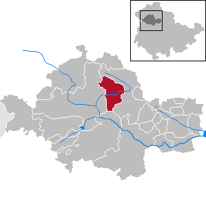
| Location of the municipality of Körner in the Unstrut-Hainich district | ||
  |
||

Körner is a rural municipality in the Unstrut-Hainich district in Thuringia in Germany . The town of Nottertal-Heilinger Heights is the fulfilling municipality for grains .
geography
Natural conditions
_01.jpg)

Körner is located about 12 kilometers east of Mühlhausen in the transition area between the Northwest Thuringian shell limestone rim plates in the north and the Thuringian Basin , a Keuper hill country in the south. The community is embedded in the open arable landscape that is used intensively for agriculture and is flowed through by the Notter , a tributary of the Unstrut . In the north, the Volkenroder Forest is the only large forest area .
Community structure
The municipality of Körner consists of the three districts of Körner, Volkenroda and Österkörner . The Bergmühle estate to the east of the village, with its house from 1907 and the associated farm buildings, is characteristic of the village.
history
A diploma from Emperor Karl dated September 15, 802, in which the place was named "Corneri", is considered the first documentary mention. The nobles von Körner, who lived in the village around 900, were builders of a small castle complex with a strong tower. The siege of the Reichsburg Volkenroda was followed by its destruction under the terms of the negotiated peace treaty. Before that, fierce fighting raged for several months between King Heinrich IV and the rebellious Thuringians and Saxons, which also encroached on the area of Körner. The Hasungen Abbey received 1,081 ownership in grains overwritten. The church of Körner was documented in the documentary tradition. From 1131 the Cistercian monastery Volkenroda was built in the vicinity of the village on the site of the destroyed Reichsburg. In 1150 the monastery church there was consecrated by the Archbishop of Mainz. Some of the places near the Volkenroda monastery were dissolved by the conversion into farmhouses (Grangien), the already largely depopulated neighboring town of Österkörner was also transferred to the Volkenroda monastery . Plots of land still privately owned by Vogts von Körner with a chapel were handed over to the Volkenroda Monastery by his heirs. Against this, there were objections from other relatives of the deceased who were entitled to inherit. For this reason, the case reaches the landgrave's court. The mill complex of mountain mill and brick mill that was built on the Notter was first mentioned in 1285. The Lords of Körner had fallen out of favor with the Landgraves of Thuringia in 1315 and their rights and remaining possessions were withdrawn. The place was sold with the two churches, the upper church and the lower church , and the castle Körner to the monastery Volkenroda. The lower church was rebuilt and repaired in 1318, it was named "Beatae Maria Virginis" (Church of the Blessed Virgin Mary) at the inauguration.

One of the oldest buildings in the village was built in 1483 as a community tavern and still serves this original purpose as the “Nottertal” inn. In 1525 insurgent farmers besieged and ravaged the Volkenroda monastery. When the farmers left, many buildings were set on fire. The reconstruction of the monastery, which had initially started, was soon abandoned. Only the most important farm buildings were repaired or partially renewed. In 1540 it was decided to dissolve the Volkenroda monastery.
A major fire in 1596 destroyed large parts of the village of Körner. After the Thirty Years War, Körner was taken over by the Duchy of Saxony-Gotha in 1645 with the office of Volkenroda .
Two other major fires destroyed parts of the village in 1733 and 1836. In 1845 the residents decided to found their own fire department. As a result of the unrest of 1848, a vigilante group was founded and 160 men were put under arms.
In 1869, as a result of the regional reform in the Duchy of Saxony-Coburg and Gotha, offices and administrations were restructured. The village of Volkenroda, which still had a few houses, was incorporated into Körner. As a forerunner of a factory, the first steam saw mill was built in Körner in 1870. The construction of a railway line from Ebeleben to Mühlhausen leads through the Nottertal and provides the villages of Körner and Österkörner with a railway connection. Railway operations were opened in 1896. A steam brickworks was opened as the second industrial company in 1907. The existing track system reduced the transport costs and the purchase of coal for the furnace.
The First World War resulted in the deaths of 48 soldiers from Körner, in the Second World War 122 people died. The farms and state estates located in the area around Körner were occupied with evacuees and refugees during the Second World War, some of this group and other displaced persons stayed in the area after the end of the war and were provided with farmland and cattle during the land reform. The establishment of the LPGs in the 1950s took place separately in all districts (Körner, Volkenroda, Österkörner and Peißel). Many small farmers switched to potash mining at this time, as VEB Kalibergwerk Volkenroda guaranteed them better wages and benefits.
By resolution of the state government of the GDR, the town of Körner and its districts were allocated to the newly created district of Erfurt and the district of Mühlhausen in a municipal and territorial reform in 1952 . The previous farms in Körner were combined in 1959 to form the LPG "Red Banner". The smallest district of Körner - the remote Peißel homestead - was relocated in 1965. For the schoolchildren in the village of Körner, the learning conditions were improved with the construction of schools and a gym in the 1970s. In 1984 the town of Körner was given a shopping center for everyday goods. The place was further developed in the late 1980s with the construction of almost 90 apartments on Lindenweg (outskirts). After the fall of the Wall, the rectory was renovated and an interest group was founded to save the ruins of the Volkenroda monastery as a cultural monument.
In 1996 the unprofitable railway line was stopped. In 1999, Körner became part of the Schlotheim administrative association. As a Thuringian contribution, the EXPO in Hanover showed two projects for village development in rural areas, which were implemented with the participation of the residents of Körner. After the end of the EXPO, the exhibition pavilion for the Volkenroda monastery was made available and rebuilt on site. With a festival week in the summer of 2002, Körner celebrated the 1200th anniversary of the first mention of the place.
Personalities
- Friedrich Christian Baumeister (1709–1785), philosopher
- Karl August Friedrich Brückner (1803-1853), educator and historian
- Alwin Langenhan (1850–1916), teacher, writer, fossil collector and amateur paleontologist
- Hermann Braun (1882–1948), administrative lawyer
- Joachim Cardinal Meisner (1933-2017), Roman Catholic Bishop, spent his youth in grains
Traditions
The village community maintains rural traditions. The most important event is the Kirmes (parish fair). Other traditional events that take place every year are the Easter bonfire and the setting of the Whitsun May (young birch trees) for the confirmands in front of the church and village tavern, as well as thanks for the sponsors of the fair.
traffic
The Körner station was on the Ebeleben – Mühlhausen railway line . Freight traffic was discontinued at the end of 1994 and passenger traffic on May 31, 1997. The line has been closed since August 15, 1998 .
Curiosities
With 99998, Körner - together with the former municipality of Weinbergen - has the highest postcode in the Federal Republic of Germany ; the guide number 99999 is not assigned. On September 9, 1999, Deutsche Post AG used the location for advertising purposes and on that day put the last-mentioned postcode in a special stamp in order to please all lovers of original stamps.
Sports
- Football: SV Fortuna 49 grains e. V., division: regional league
literature
- Heinz Freybote: Local Chronicle Volkenroda - Municipality of Körner. sn, Mühlhausen 1994.
- Astrid Münzberg, Bernd Münzberg (Red.): 802-2002. 1200 years of grains. Local authority Körner, Körner 2002.
Web links
Individual evidence
- ^ Population of the municipalities from the Thuringian State Office for Statistics ( help on this ).
- ↑ Großmann, Manfred, 1961-: The Hainich: a geographical inventory in the area of Mühlhausen, Bad Langensalza, Schlotheim, Großengottern, Mihla and Behringen . Cologne, ISBN 978-3-412-22300-7 , p. 251 f .
Anrode | Bad Langensalza | Bad Tennstedt | Ballhausen | Blankenburg | Bruchstedt | Dünwald | Greater Vargula | House summer | Autumn life | Hornsummer | Kammerforst | Kirchheilingen | Grains | Kutzleben | Marolterode | Menteroda | Midsummer | Mühlhausen / Thuringia | Nottertal-Heilinger Heights | Oppershausen | Rodeberg | Schönstedt | Südeichsfeld | Sundhausen | Dead life | Unstrut-Hainich | Unstruttal | Primeval life | Bailiwick