
Vienenburg potash plant
| Vienenburg potash plant | |||
|---|---|---|---|
| General information about the mine | |||
 |
|||
| other names | Hercynia Union | ||
| Mining technology | Chamber construction | ||
| Funding / year | up to 252,719 t | ||
| Funding / total | 6,831,575 t of potash salt | ||
| Rare minerals | Carnallitite , sylvinite , kainite , kieserite | ||
| Information about the mining company | |||
| Operating company | Preussag AG | ||
| Employees | 460 (in 1929) | ||
| Start of operation | 1884 | ||
| End of operation | May 8, 1930 | ||
| Funded raw materials | |||
| Degradation of | Potash salt / potash salt | ||
| Potash salt | |||
| Staßfurt | |||
| Mightiness | 16 m | ||
| Raw material content | 14.5 to 17% | ||
| Greatest depth | 675 m | ||
| Potash salt | |||
| Degradation of | Potash salt | ||
| Ronnenberg | |||
| Mightiness | 36 m | ||
| Raw material content | 20 to 50% | ||
| Greatest depth | 675 m | ||
| Geographical location | |||
| Coordinates | 51 ° 57 '35 " N , 10 ° 34' 1" E | ||
|
|||
| Location | Shaft I, 38690 Vienenburg | ||
| local community | Goslar | ||
| country | State of Lower Saxony | ||
| Country | Germany | ||
| District | Resin; Northern Hanover Potash District | ||

The potash plant Vienenburg was a mine of potash with attached fertilizer factory near Vienenburg in Lower Saxony Harz mountains . As a result of a sudden, strong lye ingress on May 8, 1930, which completely flooded the entire mine within a few days, mining and production had to be stopped.
geology
The formation of the Vienenburg salt dome
The salt dome of Vienenburg is one of around 200 known deposits of this type in northern Germany and part of the saline structures of the subhercyneal basin , which extends from the northern edge of the Harz to the Flechtinger mountain range. The salt layers from which the Vienenburg salt dome was formed were formed around 260 million years ago at the time of the Zechstein , when sea water evaporated in a shallow sea basin (see → Zechstein Sea ). The salt layers were later covered by further deposits, so that today they are in many places at a depth of around 3000 m or lower. However, several million years ago the salt began to collect underground in certain areas and from there to rise towards the surface of the earth - a process known as halokinesis . One such area is located north of Vienenburg today, where the salt pierced the layers of the red sandstone , pushed it upwards and erected it as a narrow saddle . This formed the ridge of the Harly Forest .
Geographical location and extent
The salt level of the Vienenburg salt dome, i.e. the upper limit, is about 200 meters deep. The salt dome has an extension of 5200 meters and strikes from west-north-west to east-south-east, this corresponds to the Hercynian strata of the northern Harz rim fault . The western boundary is roughly at the federal highway 82 between Weddingen and Beuchte , the eastern one at the so-called Weißen Ross on the highway from Vienenburg to Lüttgenrode .
The potash deposits dip vertically and are located on the northern edge of the salt dome in the immediate vicinity of the red sandstone. In the vicinity of what will later be Shaft I, there was only the older Stassfurt potash deposit with a thickness of 16 meters. Further to the west in the area of shaft II, a younger camp was also discovered, which was later referred to as the Ronnenberg seam . It was between 15 and 36 meters thick. Because of this potash seam, the later potash works belonged to the North Hanoverian potash district , although the deposit is geologically located in the Magdeburg-Halberstädter Mulde .
mineralogy
The mass of the salt dome consists of rock salt . In the Staßfurt camp, the potash salt is formed from carnallite mixed with kieserite . The potassium chloride levels are between 14.5 and 17%. The Ronnenberg camp consists of carnallite with 18 to 22% KCl and higher quality sylvinite with 20 to 50, on average 35% KCl.
History and technology
Revelation story
In the early 1880s, the Vienenburg salt dome was examined by several drilling companies. While the drilling of the Ottoshall and Neu-Vienenburg unions only revealed rock salt, the drilling of the later Hercynia union in 1883 found a potash deposit at a depth of 310 meters . This meant the first evidence of potash salts outside the core area of Staßfurt in Anhalt and at the same time the first discovery in the Kingdom of Hanover .
A consortium of different private investors and banks from Hamburg, Berlin and the Rhineland was formed under the leadership of the mine director Wilhelm Castendyck . The interest in the potash deposit and the expectation of high achievable profits were extremely high at the time. A contract on mining rights was concluded with the landowner, the Hanover Monastery Chamber. A production interest rate of two pfennigs per hundredweight of potash salt was agreed. In addition, 8% of the net proceeds were awarded to the monastery chamber. The Berechtsame the union Hercynia included a total of 15.7 square kilometers. To the west they bordered the mining fields of the Salzdetfurth trade union , to the east and south to those of the Neu-Vienenburg and Vienenburg-Wiedelah potash drilling companies .
Hercynia potash mine


As early as 1884, the sinking of the first shaft began, which was initially named after the financial institution Neubauer . During the sinking work, small caustic inflows occurred at a depth of 230 meters. During the construction of the shaft, the necessary operational buildings such as the boiler house and machine house, raw salt mill, workshops and administrative and social buildings were built. The colliery area on the south-eastern edge of the Harly forest was connected to the Reichsbahn line Vienenburg – Grauhof – Langelsheim by a connecting railway. A factory for fertilizers and other products such as bromine was built in Langelsheim to process carnallitite . The first potash salt was extracted from the 450 meter deep new shaft as early as 1886.
When mining moved west in the early 1890s, a second potash deposit with even higher potassium chloride contents was found. This salt formation was later discovered on other salt domes in Lower Saxony and was named after the Alkaliwerke Ronnenberg AG . From 1894 to 1897, shaft II was sunk to a depth of 453 meters from 1894 to 1897 to open up the new seam and to meet the demands of the mountain police for a second mobile day exit . The shaft was designed as the main production shaft and shortly after its completion it was sunk further to 600 meters. It was connected to shaft I on a total of six civil engineering levels. On the mine site of Shaft II, in the forest above the Wöltingerode monastery and near the railway line to Grauhof, extensive daytime facilities and a factory for the processing of sylvinite were built. The construction of the Hercynia potash plant cost the then high amount of 5.5 million marks up to the completion of shaft II . The equipment included the most modern technology available at the time. From 1894 the chemist Wilhelm Feit took over the management of the plants in Vienenburg and Langelsheim.
The salt was extracted using the roof chamber construction method . The chambers were excavated to a length of 40 meters, a width of 16 meters and a preliminary height of 2.2 meters using drilling and shooting work . By cross shooting the ridges in three sets of 2.5 meters, the height was increased to ten meters. In ignorance of the associated dangers, the mines in the first few years were brought up to the leaching zone on the border of the salt dome with the adjacent rock. The loose debris was loaded by hand into 0.6 ton trucks . These were pulled in trains of ten wagons with pit horses over the main conveyor lines to the day shafts. Electric contact wire locomotives took over the promotion as early as 1904 .
The crude salts extracted were ground and processed in the factories using the hot-dissolving process. To separate the salts from one another, use was made of their different solubility at different temperatures. The residue from the factory consisted mainly of rock salt and was used as offset returned to the pit. In Vienenburg, therefore, none of the characteristic tailings piles were created as in most of the other plants.
The Hercynia potash plant operated with great profit. In 1896, after a crude salt extraction of 148,043 tons per Kux, a yield of 15,700 marks was paid. After the potash plant was built, the population in Vienenburg grew from 6,276 in 1885 to 9,418 in 1905. The mine caused a surge in the number of other businesses and businesses.
The takeover by the Prussian state after 1906


As a result of the potash boom at the beginning of the 20th century, numerous potash mines had been built in many places in Germany. The Prussian state therefore saw its influence on this flourishing branch of industry threatened by the predominantly private mines. For this reason, a resolution was passed in the Prussian state parliament to take over the powerful Hercynia potash plant in Vienenburg. After negotiations by Mining Captain Max Fürst zu Halle with the board of directors of the Hercynia trade union, the potash plant with all rights and properties was acquired by Prussia for a record sum of 30.95 million marks. The high purchase price was justified in Parliament by the fact that Vienenburg accepted high stocks of high-quality salts. At the time of the takeover, a total of 112 million tons of potash was expected. A royal mining inspection was set up in Vienenburg and the plant continued to operate under the name Kaliwerk Vienenburg .
With the outbreak of World War I , the production fell from 227,000 tons in 1913 to 121,000 tons in 1914. After the end of the war, the demand for potash products quickly picked up again. This was also promoted by the statutory promotion of the voluntary shutdown of potash plants to regulate potash production in the so-called German Potash Indicator . At the Vienenburg potash plant, the 675 m level was driven as the seventh level in 1920. At the same time, both shafts were converted to electrical tower hoisting systems . Floor conveyor steam engines had previously been in operation. The construction of the new headframe in steel frame construction corresponded to the headframe of the Kaiserin Augusta shaft in Lugau , which was also built in the 1920s and still exists today .
The time after the founding of the Prussian Mining and Hütten-Aktiengesellschaft in 1923 was characterized by the further expansion of the potash plant and rationalization measures . The mining operations were centralized and shaking chutes and roller holes were introduced for intermediate conveyance . The factory residues were brought into the empty excavation chambers as flushing backfill with saturated lye via pipes above ground . The factory in Langelsheim was closed and combined with the modernization of the facilities in Vienenburg.
Despite a ban on sinking potash shafts on June 8, 1916 as a regulator for sales relationships on the potash market, Preussag received a permit for a third shaft. Shaft III , also called Röhrigschacht (after Arnold Röhrig , * December 30, 1875, † October 22, 1949, General Director of Preussag from 1923 to 1934), was sunk from 1925 to 1928 at a distance of 2,300 meters west of Shaft II. It received an underground connection with shaft II on the second and third building levels and was 623 meters deep. The construction had become necessary because the dismantling shifted further and further to the northwest. Since 1926 there has been no more mining in the area of shaft I.
The mining disaster of May 8, 1930


In 1926, water inflows occurred at depths of 230 and 318 meters at Shaft I in the Old Man . Here the potash seam was only separated from the hanging red sandstone by a few meters thick layer of rock salt . During investigations this was always found dry and the cause of the inflows could not be clarified. Preussag therefore considered a water ingress to be possible, but not likely within the next two decades.
While exploring a chimney at the edge of the deposit, on May 8, 1930, during the morning shift, the mountains suddenly collapsed between the cavity and the gypsum dome of the salt dome. In the process, such large masses of water flowed into the pit that any damming work failed and the entire workforce had to flee the mine via shaft III.
Within a day, a crater with a diameter of 100 meters, a depth of 30 meters and a volume of 450,000 m³ formed over the point of the collapse . The track body of the railway line to Langelsheim fell into the depths and the tracks were suspended in the air. The train traffic was interrupted for several weeks and had to be rerouted. In the days after the accident, 17 more sinkholes occurred in the southeast of Vienenburg up to the White Horse . Among other things, the Vienenburg freight yard and the sugar factory were severely damaged . All Vienenburg fountains dried up for a few days.
On June 4, 1930, shaft I was full of water up to 30 meters below the hanging lawn bench . All efforts to save at least shaft III were unsuccessful. Until December 1930, some of the employees still helped with clearing and backfilling work. The potash plant was then liquidated and the daily facilities sold for demolition.
In 1960 there was another daybreak in the Oker river bed near Lake Vienenburg . At the end of the 1980s, houses on the site of the former shaft II were cleared because experts feared further damage to the mine.
Considerations for recommissioning
After the end of the Second World War , the demand for potash salts on the world market grew steadily. 60% of the German potash works were located on the territory of the newly founded German Democratic Republic (→ Kombinat Kali ). In this way Preussag lost its Staßfurt and Bleicherode plants and only owned the Buggingen plant . Therefore, in 1950, considerations arose to recommission disused potash mines, including the Vienenburg potash plant.
For a resumption of mining, the deposit had to be reassessed in terms of economic efficiency . Only the areas of the potash stores to the west and below the drowned mine workings came into question . To this end, after appropriate preparatory work, a total of three wells were drilled between 1952 and 1954: Well K1 was located between shafts II and III and was 1209 meters deep. Potash salts of the known quality were detected here. No potash salts were found with well K2 on the road from Weddingen to Beuchte and with the 865 meter deep well K3 a carnallite seam only one meter thick. Given an annual production of 1,000,000 tonnes, the drilled reserves would not have justified the complex and costly construction of at least two new pits. Last but not least, the flooded old routes would have been a constant danger. This lost the euphoria and hope of the Vienenburg population for new jobs in mining in the structurally weakened border region .
Current condition
Today (2010) the former colliery sites of the two pits I and II are clearly recognizable from a distance as leveled areas on the edge of the Harly forest and are re-used as residential areas. A few buildings have been preserved, but they are not clearly recognizable as former operating buildings of a mine.
Shaft I was on the street of the same name northeast of the Vienenburger See recreation area . After a sharp right bend, the road leads to the elongated mine area in a northwest-southeast orientation. The most striking is the former administration building in the south. Opposite him, on the other side of the street, is the clearly recognizable covered manhole . Two workshop buildings still exist in the east. A little above the Zechenplatz in the forest is the former director's villa.
In the crater of the collapse of 1930, the Gläser company built a factory for motorcycle fairings.
Shaft II was north-east of the Wöltingerode monastery. Today only a few smaller buildings are scattered across the extensive grounds of the conveyor system and the potassium chlorine factory, including the former laboratory . The covered shaft can still be seen, but is difficult to find between the vegetation.
Apart from the embankment of the connecting railway, no remains of shaft III have survived.
In Vienenburg itself, the former workers' settlement of the miners was in today's residential area between Goslarer Strasse (main street), Schachtweg , Rabeckbreite and Breslauer Strasse .

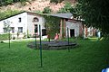
Former administration building on shaft I (today residential building)
Covered shaft I on private property, in the background the former electrical center

Glasses production building in the collapse crater from 1930

Former residential colony of the miners Schachtweg


literature
- Rainer Slotta : Technical monuments in the Federal Republic of Germany . tape 3 : The potash and rock salt industry . German Mining Museum, Bochum 1980, p. 650-660 .
- Herbert Müller: History of the city of Vienenburg . Historical illustrated book. From the beginning until 1945 . Jost-Jetter Verlag, Heimsheim 1997, p. 119-137 .
- Herbert Müller: History of the city of Vienenburg . II. Historical illustrated book. Vienenburg until 1965 . Jost-Jetter Verlag, Heimsheim 1999, p. 48-64 .
Individual evidence
- ^ Kurt Mohr: Harz foreland . western part. In: Collection of geological guides . tape 70 . Bornträger brothers, Berlin / Stuttgart 1982, ISBN 3-443-15029-2 .
- ^ Rudolf Vierhaus: German biographical encyclopedia. Walter de Gruyter, 2007.
- ↑ Herbert Müller: Exploratory drilling in the Harly. Research on the renaissance of potash mining in Vienenburg . In: Nordharzer Zeitung . February 2010, p. 8 .
Web links
- The history of the K + S Group ( Memento from October 31, 2015 in the Internet Archive ) PDF, 2.77 MB. Retrieved October 31, 2015.
- Glasses of accident protection panels