
Chemnitz-Klaffenbach
 district and statistical district No. 41 of Chemnitz |
|
|---|---|
 |
|
| Coordinates | 50 ° 45 ′ 40 " N , 12 ° 54 ′ 50" E |
| surface | 8.66 km² |
| Residents | 2273 (Dec. 31, 2013) |
| Population density | 262 inhabitants / km² |
| Incorporation | Jan. 1, 1997 |
| Post Code | 09123 |
| prefix | 0371 |
| Transport links | |
| tram | C11 |
| bus | 39 |
Klaffenbach is the most southern part of the city of Chemnitz . It is bordered by the districts of Markersdorf , Harthau and Einsiedel as well as the district of Adorf of the Neukirchen community and the Burkhardtsdorf community . The highest elevation of Klaffenbach and the entire city of Chemnitz is the Klaffenbacher Höhe (523.4 m).
history


Klaffenbach is one of the oldest places in the Chemnitz district . It is mentioned in a document as early as 1200. At that time a dense jungle covered the Ore Mountains. Emperor Lothar made the decision to build a monastery in the care of today's Chemnitz . He therefore donated a piece of land to the Roman Church. This entrusted the administration of the imperial gift to monks from the Benedictine monastery in Pegau . In 1136 the new monastery was inaugurated. The monks made the associated lands arable and brought Franconian settlers into the country. Around 1200 Klaffenbach is mentioned as a place belonging to the monastery area. So it can be assumed that Klaffenbach was created around 1150.
The name Klaffenbach derives from Glava Bog, the murder site, in connection with the legend of the St. Arno Cross about the Bishop Arno of Würzburg . This cross, which is located in the upper part of the village, is a boundary stone of the Chemnitz monastery. Others interpret Klaffenbach as a brook in the Klaffe, a narrow, deeply cutting valley. Still others derive the name from rattling, murmuring brook. These last two interpretations are more likely. The first written mention is Claffinbach.
Around 1537 Klaffenbach had about 250 inhabitants, 28 wealthy and 20 housemates . Around 1539, as a result of the Reformation, the monastery was closed. Klaffenbach, Burkhardtsdorf and Neukirchen were bought by Wolf Hünerkopf in 1543 . Klaffenbach was hit by witch hunts in 1593 , and Martin Marx got into a witch trial . In the 17th century, the plague broke out during the Thirty Years' War from 1632 to 1634. From 1543 on, the Klaffenbachers had to do labor services on the Neukirchen manor. After the French Revolution, a riot broke out on August 20, 1790.
On January 1, 1997, Klaffenbach was incorporated into Chemnitz.
Administrative affiliation
The affiliation to the higher-level administrative unit was subject to minor changes over time.
- 1590: Chemnitz Office
- 1764: Chemnitz Office
- 1816: Chemnitz office
- 1843: Chemnitz office
- 1856: Chemnitz court office
- 1875: Headquarters Chemnitz
- 1952: Chemnitz district
- 1994: Stollberg district
- 1997: District-free city of Chemnitz
- 2008: District-free city of Chemnitz
Attractions
The Klaffenbach moated castle is a popular excursion destination and venue for cultural activities. It was built in the 16th century and until 2008 housed the Museum of Saxon Vehicles . The main building is surrounded by a moat and thus has the character of a moated castle.
traffic
On the Chemnitz – Stollberg (Sachs) railway line, which was opened in 1895 , the City-Bahn Chemnitz has been operating a regional light rail system with two stations bordering Klaffenbach since December 15, 2002. From the Neukirchen-Klaffenbach and Klaffenbach stopping points, bus route 39 operated by CVAG provides access to the entire area.
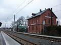
Reception building of the Neukirchen-Klaffenbach train station (2016)

Reception building of the Neukirchen-Klaffenbach train station with City-Bahn (2016)

Railway line at the Klaffenbach stop

Klaffenbach stop (2016)

Klaffenbach stop with City-Bahn (2016)


.JPG)
.JPG)
literature
- Without an author: The district of Chemnitz in historical views . Geiger Verlag, Horb am Neckar 1992, ISBN 3-89264-730-5 , pp. 116-121, history of the places in the former district of Chemnitz : Klaffenbach - with Neukirchen Castle
Web links
- Klaffenbach in the Digital Historical Directory of Saxony
- Information about Klaffenbach (private website)
- History Association Klaffenbach e. V.
Individual evidence
- ↑ Manfred Wilde : The sorcery and witch trials in Kursachsen , Cologne, Weimar, Vienna 2003, p. 596.
- ^ StBA: Changes in the municipalities, see 1997
- ↑ Information from the Digital Historical Directory of Places

Districts: Adelsberg | Altchemnitz | Altendorf | Bernsdorf | Borna-Heinersdorf | Ebersdorf | Erfenschlag | Furth | Gablenz | Glösa-Draisdorf | Harthau | Helbersdorf | Hilbersdorf | Hat wood | Kapellenberg | Kappel | Kassberg | Lutherviertel | Markersdorf | Morgenleite | Rabenstein | Reichenbrand | Reichenhain | Rottluff | Chemnitz Castle | Schönau | Siegmar | Sonnenberg | Stilt village | Yorck area | center
Locations: Einsiedel | Euba | Grüna | Klaffenbach | Kleinolbersdorf-Altenhain | Mittelbach | Röhrsdorf | Wittgensdorf
Districts in localities: Berbisdorf | Murschnitz