Larrañaga (Montevideo)
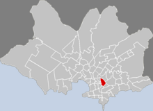
Larrañaga is a district ( barrio ) of the Uruguayan capital Montevideo .
location
It is located north of the city center in the central south of the Montevideo department . Larrañaga borders on the Tres Cruces and La Blanqueada districts in the south and southeast . To the west lie the districts of La Comercial and Jacinto Vera . Mercado Modelo y Bolívar connects to the north , while Unión continues the urban area in the east .
The area of the district is included, starting from the southwest in a clockwise direction, from the border line formed by the following streets: Avenida Gral. José Garibaldi , Cunapiru , Martin Fierro , Don Quijote , Caribes , Bulevar Artigas , Avenida Dr. Luis Alberto de Herrera , Avenida 8 de Octubre . The streets known as General Lúcas Píriz , Alejandro Chucarro and Tomás Gomensoro at least at the beginning of the 20th century lead through the barrio . The area of the Barrio Larrañaga is the municipality C assigned.
history
The barrio was founded in 1886 on Camino Larrañaga between Goes and Monte Caseros by Francisco Piria on his own land. The area of the barrio at that time comprised an area of around four hectares. At the beginning of the 20th century it was sparsely populated and had numerous small orchards and vegetable gardens.
Infrastructure and description
education
In the quarter is the Instituto Metodista Universitario Crandon and the Colegio Liber Falco, founded in 1995 on Bulevar Artigas .
Sports
Larrañaga is the seat of the traditional football club Nacional Montevideo , which, however, assigns this area of the city in which it is located to the La Blanqueada district on its website .
Places and sights
On the corner of Avenida Grail. José Garibaldi , Monte Caseros is the Plaza Budapest .
Web links
Individual evidence
- ↑ Map of the Uruguayan National Statistics Institute for the classification of the barrios of Montevideo (PDF; 1.6 MB), accessed on May 3, 2014
- ↑ a b Orestes Araújo : "Diccionario geográfico del Uruguay", Montevideo, 2nd edition 1912, p. 257
- ↑ Official website of the Instituto Metodista Universitario Crandon ( Memento of the original from December 20, 2007 in the Internet Archive ) Info: The archive link has been inserted automatically and has not yet been checked. Please check the original and archive link according to the instructions and then remove this notice.
- ↑ www.universitariocrandon.edu.uy
- ↑ Official website of the Colegio Liber Falco ( Memento of the original from April 22, 2013 in the Internet Archive ) Info: The archive link has been inserted automatically and has not yet been checked. Please check the original and archive link according to the instructions and then remove this notice.
- ↑ Official website of Nacional Montevideo
Coordinates: 34 ° 53 ′ S , 56 ° 10 ′ W


