Municipio Ahumada
| Ahumada | ||
|---|---|---|

|
||
| Symbols | ||
|
||
| Basic data | ||
| Country | Mexico | |
| State | Chihuahua | |
| Seat | Miguel Ahumada | |
| surface | 16,927.6 km² | |
| Residents | 11,457 (2010) | |
| density | 0.68 inhabitants per km² | |
| founding | 1894 | |
| INEGI no. | 08001 | |
| politics | ||
| Presidente municipal | Juan de Dios Valle Camacho | |
| Plaza del Reloj in Miguel Ahumada | ||
Coordinates: 30 ° 25 ′ N , 106 ° 22 ′ W
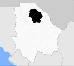
Ahumada is a municipality with a good 11,000 inhabitants in the Mexican state of Chihuahua . With an area of 16,927.6 km², the municipality is the largest in the state and sixth largest in Mexico. The administrative seat and largest place in the municipality is Miguel Ahumada , called Villa Ahumada . The municipality bears his name as well as its main town in honor of the former governor of Chihuahua, Miguel Ahumada .
geography
The Municipio Ahumada is located in the north of the state of Chihuahua at an altitude between 1100 m and 2500 m . It belongs entirely to the physiographic province of the Sierras y Llanuras del Norte . 99.9% of the community area is in the endorheic basin of the Cuencas Cerradas del Norte , 0.1% is in the hydrological region Bravo - Conchos and drains into the Gulf of Mexico . The geology of the municipality is determined with over 48% of alluvions with 17% conglomerate rock , 9% aeolian sediments and 8% rhyolite tuff ; The predominant soil types in the municipality are Calcisol (29%), Regosol (24%), Leptosol (21%) and Solonetz (8%). 61% of the municipality is taken up by scrub landscape, 33% are used as pasture land.
The municipality is surrounded by the municipality of Ascensión , Juárez , Guadalupe , Coyame del Sotol , Aldama , Chihuahua and Buenaventura .
population
The 2010 census counted 11,457 people in 3115 residential units in the municipality. Of these, 32 people were registered as speakers of an indigenous language , including 12 speakers of the Tarahumara language . About 3.7% of the population were illiterate. 4,487 inhabitants were registered as economically active, of which approx. 74% were men and approx. 3.8% were unemployed. 3.4% of the population lived in extreme poverty.
places
The Municipio Ahumada comprises 135 inhabited localidades , of which only the main town is classified as urban by the INEGI . In the 2010 census, ten towns had a population of over 100. The biggest places are:
| place | Residents |
| Miguel Ahumada | 8575 |
| Ojo Caliente ( Colonia Seca ) | 514 |
| Colonia Valle de la Esperanza | 292 |
| Álamos de Peña | 269 |
Web links
- Enciclopedia de los Municipios y Delegaciones de México: Municipio Ahumada (Spanish)
- INEGI : Datos Geográficos: Municipio Ahumada (Spanish; PDF)


