Municipio Madera
| Madera | ||
|---|---|---|

|
||
| Symbols | ||
|
||
| Basic data | ||
| Country | Mexico | |
| State | Chihuahua | |
| Seat | Madera | |
| surface | 8,748.4 km² | |
| Residents | 29,611 (2010) | |
| density | 3.38 inhabitants per km² | |
| founding | 1911 | |
| INEGI no. | 08040 | |
| politics | ||
| Presidente municipal | Jaime Torres Amaya | |
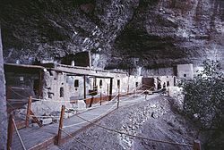
| The archaeological site of Cuarenta Casas , located in the municipality of Madera | ||
Coordinates: 29 ° 21 ′ N , 108 ° 16 ′ W
Madera is a municipality with around 30,000 inhabitants in the Mexican state of Chihuahua . The municipality has an area of 8748.4 km². The administrative seat and largest place of the municipality is the eponymous Madera .
The municipality of Madera includes the archaeological sites of Complejo Huapoca and Cuarenta Casas and parts of the Tutuaca and Campo Verde nature reserves.
geography
The municipality of Madera is located in the west of the state of Chihuahua at an altitude between 600 m and 2900 m . It belongs entirely to the physiographic province of the Sierra Madre Occidental . 86.4% of the municipality is in the hydrological region of Sonora Sur and drains into the Gulf of California , the rest in the endorheic basin of the Cuencas Cerradas del Norte (Casas Grandes) . The geology of the municipality is determined by 50% rhyolite tuff with 41% basalt and 4% alluvion ; The predominant soil types in the municipality are the Phaeozem (50%), Umbrisol (13%), Luvisol (9%), Cambisol and Leptosol (8% each). 90% of the municipality is forested, 6% are used for agriculture, 4% are used as pasture land.
The municipality borders the municipalities Casas Grandes , Ignacio Zaragoza , Gómez Farías and Temósachi as well as the state of Sonora .
population
In the 2010 census, 29,611 people in 8,271 residential units were counted in the municipality. Of these, 264 people were registered as speakers of an indigenous language , including 186 speakers of Pima. 5.8 percent of the population were illiterate. 10,637 inhabitants were registered as economically active, of which 77% were men and 6.5% were unemployed. 9.2 percent of the population lived in extreme poverty.
places
The municipality Madera comprises 220 inhabited localidades , of which, in addition to the main town, El Largo and Nicolás Bravo are classified as urban by the INEGI . In the 2010 census, 15 towns had a population of over 200. The biggest places are:
| place | Residents |
| Madera | 15,447 |
| El Largo | 3,522 |
| Nicolás Bravo | 1,862 |
| Las Varas ( Estación Babícora ) | 1,417 |
| Mesa del Huracan ( Chihuahuita ) | 1.102 |
| La Norteña | 822 |
Web links
- Enciclopedia de los Municipios y Delegaciones de México: Municipio Madera (Spanish)
- INEGI : Datos Geográficos: Municipio Madera (Spanish; PDF)


