Municipio of Cusihuiriachi
| Cusihuiriachi | |
|---|---|

|
|
| Basic data | |
| Country | Mexico |
| State | Chihuahua |
| Seat | Cusihuiriachi |
| surface | 1,610.6 km² |
| Residents | 5414 (2010) |
| density | 3.36 inhabitants per km² |
| founding | 1820 |
| INEGI no. | 08018 |
| politics | |
| Presidente municipal | Abel Ordoñez García |
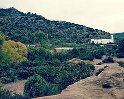
| The Parroquia de Santa Rosa de Lima in Cusihuiriachi | |
Coordinates: 28 ° 15 ′ N , 106 ° 50 ′ W
Cusihuiriachi is a municipality with about 5400 inhabitants in the Mexican state of Chihuahua . The municipality has an area of 1610.6 km². The administrative seat of the municipality is the eponymous Cusihuiriachi , while the largest place is Los Álamos de Cerro Prieto .
geography
The municipality of Cusihuiriachi is located in the center of the state of Chihuahua at an altitude between 1600 m and 2800 m . The municipality lies entirely in the physiographic province of the Sierra Madre Occidental . 50% of it is located in the endorheic basin of the Cuencas Cerradas del Norte (Casas Grandes) , 47% are in the hydrological region Bravo - Conchos and drain into the Gulf of Mexico , the remaining 3% are in the Sonora Sur region and drain in the Gulf of California . The geology of the municipality is determined by 41% conglomerate rock with 34% rhyolite tuff and 17% sandstone conglomerate; The predominant soil types in the municipality are Leptosol (34%), Luvisol (24%), Phaeozem (23%), Durisol and Vertisol (7% each). 44% of the community area is forested, 39% is used for arable farming, 13% is used as pasture land.
The municipality borders on the municipalities Guerrero , Cuauhtémoc , Gran Morelos , Dr. Belisario Domínguez , San Francisco de Borja and Carichí .
population
The 2010 census counted 5414 people in 1663 residential units in the municipality. Of these, 192 people were registered as speakers of an indigenous language , including 169 speakers of the Tarahumara language . 5.6 percent of the population were illiterate. 2095 inhabitants were registered as economically active, of which 84% were men and 1.4% were unemployed. 4.7 percent of the population lived in extreme poverty.
places
The municipality of Cusihuiriachi comprises 126 inhabited localidades , of which only the main town of the same name (63 inhabitants) is classified as urban by the INEGI . In the 2010 census, seven towns had a population of over 200, 110 towns had fewer than 100 inhabitants. The biggest places are:
| place | Residents |
| Los Álamos de Cerro Prieto | 614 |
| Cerro Prieto ( Cerro Prieto de Abajo ) | 400 |
| Chopeque | 378 |
| Colonia Cusi (Ojo de Agua) | 307 |
Web links
- Enciclopedia de los Municipios y Delegaciones de México: Municipio Cusihuiriachi (Spanish)
- INEGI : Datos Geográficos: Municipio Cusihuiriachi (Spanish; PDF)

