Nöldnerplatz
| Nöldnerplatz | |
|---|---|
| Place in Berlin | |
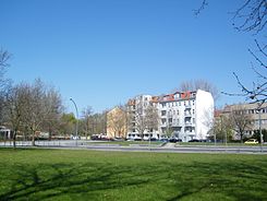
 Nöldnerplatz from the south |
|
| Basic data | |
| place | Berlin |
| District | Rummelsburg |
| Newly designed | 2006 |
| use | |
| Space design | Garden architects, green space office |
The Nöldnerplatz is a place in the Berlin district of Lichtenberg in the district Rummelsburg . It was named after the anti-fascist Erwin Nöldner, who was executed in 1944 . The square is known for the S-Bahn station of the same name and the listed school complex built by Max Taut . Nöldnerplatz largely consists of green areas that have been redesigned since the late 1990s.
Town square
Location, extent and traffic
Nöldnerplatz is located in the southwest of the Lichtenberg district, just outside the Berlin S-Bahn ring , about six kilometers from Alexanderplatz . In the area of the square, the Victoriastadt and the Weitlingkiez border each other. A few hundred meters to the south is the new residential area of Rummelsburger Bucht, which was built in the late 1990s . The square is almost triangular and almost four hectares in size. In the north of the square are the Ostbahn line , where the Nöldnerplatz S-Bahn station is also located, and the Archibaldweg. In the west, the square is bounded by the embankment of the connecting line between the Ringbahn and the Berlin-Rummelsburg depot and in the northeast by Lückstrasse. Schlichtallee, from which Fischerstraße branches off, is located on the southeast side of the square. Nöldnerstraße, which runs in an east-west direction, divides the square. There are green spaces between the streets.
In addition to the S-Bahn, the area is served by various bus routes. Bus stops are in Nöldnerstraße and directly in front of the S-Bahn station. The road connection from Weitlingkiez and the residential areas in the south of the Friedrichsfelde district to downtown Berlin runs over Lückstrasse and further on Schlichtallee or Nöldnerstrasse .
history
At the end of the 19th century, the area around the square, which at that time belonged to the rural community of Boxhagen-Rummelsburg , was largely undeveloped. A little to the east, in today's Lückstrasse, was the Lichtenberger Kietz colonist settlement that was built before 1800 . In the north-west, beyond the eastern railway line opened in 1866, the Victoria city was already largely built on. To the west of today's square in Prinz-Albert-Strasse (today Nöldnerstrasse), beyond the connecting railway to Rummelsburg built in 1879, the Church of the Redeemer was inaugurated in 1892 .
As early as 1874, a schoolhouse in the northwest corner of today's square in what was then Portlandstrasse (included in Nöldnerplatz around 1960) was completed. In 1891 the Central School Boxhagen-Rummelsburg was built on Prinz-Albert-Straße west of the square next to the Church of the Redeemer . The old school building then became the poor house of the community of Boxhagen-Rummelsburg. The building was badly damaged during World War II and then demolished. In 1896/1897 the municipality had secured a neighboring piece of land in order to build a recreational and playground there.
Since 1882 there were at the southern Berlin-Wrocław railway to Frankfurt (Oder) the breakpoint Kietz-Rummelsburg , about 300 meters from the square to the east of Kietzer road , today's Schlichtallee. At the end of the 19th century, a development plan was drawn up in which the road network and the building lines of the houses in today's Weitlingkiez were determined. Around 1900 master builder Wagenknecht bought the area between today's Lückstrasse and Fischerstrasse and had the first apartment buildings built there. In the following years the area east of the square was built with tenement houses. In 1903, the railway tracks of the Eastern Railway, which had previously been on the same level as the site, were relocated to the embankment. Streets that were once continuous, such as the one from Neue Prinz-Albert-Straße (today Lückstraße) to Kantstraße (today Kaskelstraße) have been interrupted since then. When the railway line was relocated, a station, initially called Rummelsburg Ost , was set up, today's Nöldnerplatz station. In the following years, further residential buildings were built on the northeast side of the square. In 1912 the community Boxhagen-Rummelsburg was incorporated into the city of Lichtenberg, which in turn became part of Greater Berlin in 1920.
As part of an urban planning competition, a school in the style of New Objectivity was built from 1927 to 1932 on the south-east side of the square according to plans by Max Taut . A residential area was to be built south of the school. However, because of the poor subsoil, these plans were not implemented. There are allotments there to this day. During the Second World War, a large part of the buildings on the square were destroyed. There remained three houses and the Max Taut School, which was also partially damaged.
Until the end of the Second World War, the park had no official name, it was popularly called Lindenplatz . In 1947 the facility was named Nöldnerplatz after the anti-fascist Erwin Nöldner, who had lived in the nearby Türrschmidtstrasse.
A tram line ran across the square until 1953, connecting Marktstrasse to Alt-Friedrichsfelde via Weitlingstrasse . In 1958, Portlandstrasse , which connected Archibaldweg and Nöldnerstrasse in the northwest of the square, was repealed and the site was incorporated into the green area. In the same year, a new office building was built on the west side of the square for the GDR Academy for Medical Training .
In 2003 the Lichtenberg District Office launched an urban planning competition to redesign the square. The square should be upgraded, whereby the character as a green area should be more visible. In addition, the traffic routes should be made clearer. The green area on the north side of the square has been redesigned accordingly and new playgrounds have been created.
Buildings and works of art
Apart from a functional building built in 1958 in the west of the square, which is used today by the immigration authorities, the square is only built on on its northeast and southeast side. All buildings have postal addresses in one of the adjacent streets.
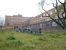
The most important building is the Max Taut School on the southeast side of the square, which is a listed building. It was built from 1928 to 1932 as part of a 1927 competition. It was only inaugurated in 1935, when the architect Max Taut had already fallen out of favor with the National Socialist rulers. The school suffered severe damage during the Second World War and the auditorium was almost completely destroyed. In the GDR era, the school complex was called the Kant Oberschule .
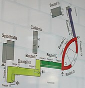
After 2000, the entire school complex was rebuilt as part of an URBAN II competition according to plans by Max Dudler . The auditorium, which had not been used for decades, was also rebuilt. The renovated school was opened to the public on December 5, 2007 and on this occasion was renamed the Max-Taut-Schule after its architect . It is used as an upper level center for supply and cleaning technology. The renovated auditorium is also used for cultural events and discussion groups for the Lichtenberg District Office. The district assembly in Lichtenberg meets every third Thursday of the month in the Max-Taut-Aula.
The residential development on Fischerstrasse and Lückstrasse is a heterogeneous ensemble of a few houses that survived the Second World War, with additions from the 1950s, 1970s and 1990s.
In the northern part of the square there was a well system built according to a design by Erwin Kobbert , which no longer exists (2017).
In 2010 the district office inaugurated a memorial stone for the Rummelsburg workers' resistance from 1933 to 1945.
At the beginning of 2019 there was an artistic design competition to improve the square. The jury awarded the first prize to the artist Christian Hasucha , who had designed the subject of the sky over Nöldnerplatz from various hewn granite stones . In January 2020 the work of art was inaugurated on a green area of the square.
use
Due to its relatively isolated location between several residential areas, no business center has emerged here. There are only a few shops on Fischerstrasse, such as a snack bar and a hairdresser. The square consists mainly of green areas that are crossed by several roads. In the north, after 2000, an area for playing children with a skate track and a bolt was converted.
railway station
history
With the elevation of the tracks of the Prussian Eastern Railway , opened in 1867 , the station was opened on October 1, 1902, initially under the name Rummelsburg-Ost . On October 1, 1914, the name was changed to Neu-Lichtenberg . On November 6, 1928, electric S-Bahn operations began on the line. The station has been named Nöldnerplatz since December 12, 1954 .
Investments
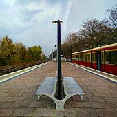
The train station (official abbreviation BNPL) at route kilometer 3.4 of the Ostbahn was operationally only one stop . Since 2018 he is groundbreaking technically a station Part of the Berlin Ostbahnhof . The only access to the platform is a pedestrian tunnel on the west side, which connects Nöldnerplatz and Kaskelstraße in Victoria City. There is no reception building, only a small supervisory house on the platform, which - like the roofing of the western half of the platform - dates from the time the station was built. The platform roof consists of a wooden roof on cast iron pillars. The entrance portal on the south side was built in the 1960s.
The platform is not barrier-free . For the installation of elevators, the access tunnel and the stairs must be completely renewed. The work can only take place after the construction work at Ostkreuz station has been completed . Deutsche Bahn is currently planning the renovation of the tunnel connecting the districts and the installation of ramps at both exits. Access to the platform is also to be rebuilt so that it is barrier-free. The work should be completed by 2026/27.
To the west of the station, the Frankfurter Allee – Rummelsburg line crosses Kaskelstrasse, the Ostbahn and Archibaldweg on a bridge. North of the S-Bahn tracks is a non-electrified track of the Eastern Railway in the direction of Lichtenberg station . This is followed by extensive storage facilities with locomotive sheds and workshop buildings. A 12,000 m² large part of this complex is since 2004 by the BLO-Ateliers manages (the acronym BLO is the abbreviation of the station Berlin-Lichtenberg in operation Jobs Directory Deutsche Bahn). Part of the sidings is used for railway operations at Lichtenberg station.
The S-Bahn station is served by lines S5, S7 and S75. There are transition options to bus routes 194, 240 and 396 (daytime traffic) and N94 (nighttime traffic).
Web links
- Nöldnerplatz. In: Street name lexicon of the Luisenstädtischer Bildungsverein (near Kaupert )
- Announcement of the urban planning competition for the redesign of the square with an announcement text and various planning drafts
Individual evidence
- ↑ Christine Steer: Rummelsburg with the Victoriastadt . be.bra-Verlag, Berlin 2010, ISBN 978-3-8148-0181-0 , p. 58
- ↑ a b The Nöldnerplatz and its history. Part 1: from the beginning to World War II. ( Memento from January 3, 2014 in the Internet Archive ) (PDF; 875 kB) In: Stadtbildinfos - newspaper of the Stadtbild Agentur Lichtenberg , 1/2008, pp. 3–4.
- ↑ a b Award of the urban planning competition 2003 (PDF; 169 kB) Client: District Office Lichtenberg
- ↑ Nöldnerplatz and its history. Part 2: from 1945 to today. (PDF; 851 kB) In: Stadtbildinfos - newspaper of the Stadtbild Agentur Lichtenberg. 2/2008, p. 3.
- ↑ Line chronicle of the Berlin tram , accessed on March 22, 2011.
- ^ New school building in Lichtenberg: vocational school, middle school and upper lyceum. In: Berliner Volkszeitung , April 10, 1929,
- ↑ The war damage has been removed. It took more than 60 years for the auditorium of the Max Taut School in Lichtenberg to be renovated . In: Berliner Zeitung , December 6, 2008
- ^ Venue of the BVV Lichtenberg
- ↑ Inauguration of the work of art “Heaven over Nöldnerplatz”. Press release from the Lichtenberg District Office, January 10, 2020.
- ↑ Printed matter 17/15247. (PDF) Berlin House of Representatives, January 20, 2015, accessed on February 2, 2015 .
- ↑ Printed matter 18/23656. Berlin House of Representatives, June 19, 2020, accessed on July 1, 2020 .
- ↑ blo-ateliers.de accessed on December 27, 2010.
Coordinates: 52 ° 30 ′ 8 ″ N , 13 ° 29 ′ 8 ″ E


