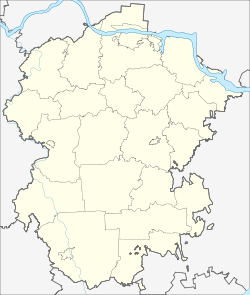
Poretskoye (Chuvashia)
Village
|
||||||||||||||||||||||||||||||||||
|
||||||||||||||||||||||||||||||||||
|
||||||||||||||||||||||||||||||||||
Porezkoje ( Russian Поре́цкое ; Chuvash Пӑрачкав ) is a village (selo) in the Republic of Chuvashia in Russia with 5825 inhabitants (as of October 14, 2010).
geography
The place is about 120 km as the crow flies southwest of the republic capital Cheboksary , a good ten kilometers from the border to the neighboring Oblast Nizhny Novgorod and a little further to the southwestern Republic of Mordovia . It is located on the left bank of the right Volga tributary Sura .
Porezkoje is the administrative center of the Rajons Porezki and seat and only town in the rural community Porezkoje selskoje posselenije.
history
The place was first mentioned in 1616 as an already larger Russian settlement, which probably emerged soon after the end of the Moscow-Kazan wars in 1552. The place belonged to the Ujesd Alatyr , which in the course of the 18th century belonged temporarily to the governorates of Kazan and Nizhny Novgorod , from 1780 finally to the governorate, from 1796 governorate Simbirsk .
With the formation of the Chuvash ASSR on April 21, 1925 from the Chuvash Autonomous Oblast, which had existed since 1920, the Ujesd Alatyr was attached to it. On September 5, 1927, the Porezki rajon was spun off from the Ujesd Alatyr, with its administrative headquarters in Porezkoje.
Population development
| year | Residents |
|---|---|
| 1939 | 6187 |
| 1959 | 5217 |
| 1970 | 5515 |
| 1979 | 6140 |
| 1989 | 6502 |
| 2002 | 6482 |
| 2010 | 5825 |
Note: census data
traffic
Porezkoye is bypassed to the west by the regional road 97K-001, which , coming from Tscheboksary via Shumerlja , crosses the Sura below the town and leads south past Alatyr into the Ulyanovsk Oblast , there as 73R-231 on to the federal highway R178 Saransk - Ulyanovsk bei Surskoye . In Porezkoye the 97K-011 branches off in a north-westerly direction, which continues in the Novgorod Oblast as 22K-0162 via Sergach and Knjaginino to the federal trunk road M7 Volga east of Nizhny Novgorod .
The nearest train station is a good 40 km north in Shumerlja on the electrified railway line Moscow - Arsamas - Kazan - Yekaterinburg ; A little further south is the Alatyr train station on the Rusajewka - Saransk - Krasny Usel - Kanasch route .
Web links
Individual evidence
- ↑ a b Itogi Vserossijskoj perepisi naselenija 2010 goda. Tom 1. Čislennostʹ i razmeščenie naselenija (Results of the All-Russian Census 2010. Volume 1. Number and distribution of the population). Tables 5 , pp. 12-209; 11 , pp. 312–979 (download from the website of the Federal Service for State Statistics of the Russian Federation)


