Saint-Étienne-Vallée-Française
|
Saint-Étienne-Vallée-Française Sent Estève de Valfrancesca |
||
|---|---|---|
|
|
||
| region | Occitania | |
| Department | Lozère | |
| Arrondissement | Florac | |
| Canton | Le Collet-de-Dèze | |
| Community association | Cevennes au Mont Lozère | |
| Coordinates | 44 ° 10 ′ N , 3 ° 51 ′ E | |
| height | 194-925 m | |
| surface | 50.99 km 2 | |
| Residents | 510 (January 1, 2017) | |
| Population density | 10 inhabitants / km 2 | |
| Post Code | 48330 | |
| INSEE code | 48148 | |
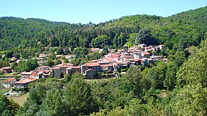
 Saint-Étienne-Vallée-Française - View of the town |
||
Saint-Étienne-Vallée-Française ( Occitan : Sent Estève de Valfrancesca ) is a place and a municipality in the south of France with 510 inhabitants (as of January 1, 2017) in the Lozère department in the Occitanie region .
location
The town of Saint-Étienne-Vallée-Française is located in the southeast of the Cevennes National Park on the upper reaches of the Gardon de Sainte-Croix river or, more precisely, its tributary Gardon de Saint-Étienne in the historical province of Gévaudan about 45 km (driving distance) southeast of Florac in a Height of approx. 250 to 280 m above sea level. d. M.
Population development
| year | 1800 | 1851 | 1901 | 1954 | 1999 | 2013 |
| Residents | 1,810 | 1,986 | 1,179 | 591 | 487 | 520 |
The population decline, which began in the second half of the 19th century, is essentially related to the remote location of the place and to the loss of jobs as a result of the increasing mechanization of agriculture .
economy
The inhabitants of Saint-Étienne lived for centuries as self-sufficiency from the yields of their fields and gardens, whereby chestnuts also played a not insignificant role. Cattle breeding (sheep, goats, cattle, chickens) was also important; Pélardon cheese is still produced in the region today . Nowadays, the rental of holiday apartments ( gîtes ) plays an important role in the economic life of the municipality.
history
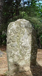
As the menhir called the stone of the old woman proves, the hunters and shepherds of the Neolithic megalithic cultures have already left their mark on the municipality. In Celtic times it belonged to the settlement area of the Gabali , which however was absorbed into the Gallo-Roman culture .
The existence of a church is documented as early as the 8th or 9th century; later Sauve Abbey founded a priory church here . After the Albigensian Crusades (1209-1229), the area came under the French crown , but was subsequently also claimed by the Bishop of Mende . In the 14th century the place had to suffer from the Hundred Years War (1337-1453) and the plague epidemic of 1348. In the 16th and 17th centuries, the Huguenot Wars (1562–1598) and the religiously motivated conflicts, which were not completely resolved by the Edict of Nantes, prevented lasting peaceful development of the place. The expulsion of the Huguenots at the end of the 17th century and the Camisard Wars at the beginning of the 18th century apparently marked the end of the religious conflicts in France, but Protestantism continued to live underground ( église du désert ).
Attractions
- Many houses in the village are built from natural stones; they used to be covered with stone shingles ( lauzes ).
- The current church dates from the 15th century, but it was almost destroyed in the religious conflicts. The tower was preserved; the nave itself was almost completely rebuilt in the 20th century.
- The local Protestant church ( temple ) is a simple building from the mid-19th century.
- The construction of the Château de Cambière began in 1366; later it was changed several times. Today the premises are used as holiday apartments.
- outside
- The legendary Menhir de la Vieille Morte is about 3 km northeast of the village ( 44 ° 10 ′ 42 ″ N , 3 ° 52 ′ 29 ″ E ).

