Sataniv
| Sataniv | ||
| Сатанів | ||

|
|
|
| Basic data | ||
|---|---|---|
| Oblast : | Khmelnytskyi Oblast | |
| Rajon : | Horodok district | |
| Height : | 299 m | |
| Area : | 1.92 km² | |
| Residents : | 2,425 (2014) | |
| Population density : | 1,263 inhabitants per km² | |
| Postcodes : | 32034 | |
| Area code : | +380 3851 | |
| Geographic location : | 49 ° 15 ' N , 26 ° 16' E | |
| KOATUU : | 6821255500 | |
| Administrative structure : | 1 urban-type settlement | |
| Mayor : | Albert Ivanovych Sobkov | |
| Address: | вул. Бузкова 135 - ж 32034 селище Сатанів |
|
| Statistical information | ||
|
|
||
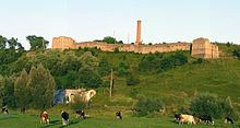
Sataniw (Ukrainian Сатанів ; Russian Сатанов / Satanow , Polish Satanów ) is an urban-type settlement in the west of the Ukrainian Oblast Khmelnytskyi with about 2,400 inhabitants (2014).
The town was first mentioned in writing in 1404 and received town charter in 1436, which was lost again. In 1514 (or 1532) the Sataniv Synagogue was built, which is believed to be the oldest synagogue in Ukraine. Between 1674 and 1699 the city belonged to the Ottoman Empire . In 1938, Sataniv received urban-type settlement status. Sataniw is the only village of the settlement council of the same name in the west of Horodok Rajon .
Sataniv is located in the Podiler Towtry National Park ( Подольские Товтры ) on the left bank of the Sbruch , a tributary of the Dniester , 66 km southwest of the Khmelnitsky Oblast center and 26 km northwest of the Horodok district center . Regional roads P-48 and P-50 cross in the settlement .
Web links
Individual evidence
- ↑ Cities in Ukraine at pop-stat.mashke.org, last accessed on June 8, 2015
- ↑ https://kehilalinks.jewishgen.org/Sataniv/Satanov%20in%20Pictures.html data, pictures of the synagogue. Retrieved February 15, 2018
- ↑ https://sztetl.org.pl/en/towns/s/1829-satanow/96-local-history/70343-local-history Sataniv Turkish. Retrieved February 15, 2018


