
Schöllenbach
|
Schöllenbach
City of Oberzent
|
|
|---|---|
 |
|
| Height : | 286 m above sea level NHN |
| Area : | 15.74 km² |
| Residents : | 225 (Dec. 31, 2018) |
| Population density : | 14 inhabitants / km² |
| Incorporation : | 1st October 1971 |
| Incorporated into: | Hesseck |
| Postal code : | 64760 |
| Area code : | 06276 |
_Sch%C3%B6llenbach_von_S%C3%BCd.jpg) Schöllenbach seen from the south from the Ittertal
|
|
Schöllenbach (also Hessisch-Schöllenbach ) is a district of the city of Oberzent in the southern Hessian Odenwald , which emerged on January 1, 2018 from the merger of the communities of Hesseneck, Rothenberg, Sensbachtal and the city of Beerfelden.
Schöllenbach has about 240 inhabitants. In addition to the core town itself, the courtyards and settlement areas Albertsruhe , Krähberg station , Hammer , Hohberg Hof , Rote Erde and Windloch belong to the Schöllenbach district.
Geographical location

_Sch%C3%B6llenbach_Badisch_Sch%C3%B6llenbach.jpg)
The street village is located at the tributary of the Schöllenbach to the Itterbach, still called Euterbach , in the Geo-Naturpark Bergstraße-Odenwald . It is separated from the smaller Badisch-Schöllenbach by the Euterbach / Itterbach , which belongs to the Baden-Württemberg town of Eberbach , 17 km away, and is located in a northern exclave belonging to the Friedrichsdorf district . Badisch-Schöllenbach consists of around 15 residential buildings with a total of 24 residents. Everyday administrative matters such as water supply, garbage disposal, cemetery use and post office are taken care of by the city of Oberzent, so that the residents are not affected. Previous efforts to change the boundary have been fruitless.
For the location between Baden and Hesse, see also Territorial features in southwest Germany after 1810 .
history

_Sch%C3%B6llenbach_Untere_Siegfriedstra%C3%9Fe_6,_8_%2B_1.jpg)
The first written mention of Schöllenbach comes from the year 1344. At this point in time, the Schenk Konrad zu Erbach acquired the village, then called Schellinbach , from the noble servant Arnold von Freienstein, who was subordinate to him . In other documents of the 14th century the place appears in the spellings Schellenbuch (1366), Schellinbuch (1370) and Schelnbuch (1398), in documents of the 15th century in the forms Schelmbach (1462), Schelinbach (not dated) and Schelnbach (1487) and in documents from the 16th century once again as Schelnbach (1553) and once as Schelnpach (unspecified).
In the second half of the 15th century, a three-aisled church with a large choir cross vault in the late Gothic style was built over a spring - presumably on the site of an older chapel - and inaugurated in 1465 by the donor Philip IV zu Erbach. Since the water was said to have a healing effect and because an image of the Virgin displayed in the church was considered miraculous, a lively pilgrimage to the Schöllenbacher church , supported by the sovereign, soon developed . In 1480 two more altars were erected on the side of the Marian altar. Count Eberhard XIII. On the occasion of his wedding to Maria von Wertheim, von Erbach finally donated the carved and richly decorated Schöllenbach Altar , which was completed in 1515 and on which the family tree of Christ is depicted, the so-called Root Jesse . After Erbach introduced the Reformation in 1560, the pilgrimages fell drastically and the church gradually fell into disrepair. The altar was moved to Erbach at the beginning of the 17th century , where it is still located today (2014). Wars and epidemics continued to affect the village and church, so that until the 18th century only a large church ruin remained. This church building, which in the end no longer had a roof, was used as a chapel for the dead. It was not until 1782 that the church was rebuilt in its present form using the existing masonry but with a significantly reduced floor plan.
A hammer forge , the so-called "Schöllenbacher Hammer", had existed in the southern Schöllenbach since around 1700 (possibly earlier) . The pig iron required for production was obtained from Uslar on the edge of the Solling . The first hammer owner, Georg Schick, handed the business over to his two sons in 1718. In 1748 the work was taken over by Johann Michael Rexroth, in 1757 it passed to the brothers Johann Ludwig and Johann Adam Rexroth. Their descendants ran the business until it was taken over by Johann Ludwig Rexroth in 1839. In 1870 the hammer operation was stopped and the plant was converted into a sawmill . Today it is only used for residential purposes.
After the Hessian part of Schöllenbach had been in Erbach's possession for centuries, the place came to the Grand Duchy of Hesse with the dissolution of the Erbach rule by the Reichsdeputationshauptschluss 1806 . As a result, it belonged to its successor states, from 1918 to 1934 to the People's State of Hesse and - after brief membership of the Nazi Gau Hessen-Nassau (1934 to 1945) and the American Occupation Zone (1945 to 1949) - since 1949 to the federal state of Hesse.

On the occasion of the regional reform in Hesse , Schöllenbach, Kailbach and Hesselbach merged on October 1, 1971 to form the new municipality of Hesseneck, which in turn formed the town of Oberzent on January 1, 2018 with other municipalities.
- Impressions from Schöllenbach

Obere Siegfriedstrasse 27

Upper Siegfriedstrasse 8

Ecksgasse 3

Hesselbachweg at the New Cemetery
_Sch%C3%B6llenbach_Obere_Siegfriedstra%C3%9Fe_27.jpg)
_Sch%C3%B6llenbach_Obere_Siegfriedstra%C3%9Fe_8.jpg)
_Sch%C3%B6llenbach_Ecksgasse_3.jpg)
_Sch%C3%B6llenbach_Hesselbachweg.jpg)
politics
Hesselbach, Kailbach and Schöllenbach have a joint local advisory board.
In the local elections on March 27, 2011, the SPD won all three mandates in the local advisory board and is therefore represented as the only party in this body. The local advisory board is a directly elected administrative body of the municipality (in Hessen, among others) , which represents the interests of the local part vis-à-vis the municipality as a whole. He has the right to make proposals and - for all important decisions - to be heard. The mayor of Schöllenbach is Rudolf Brandel (SPD).
The place was the seat of the municipal administration of the municipality of Hesseneck. The town hall was located in the former school, a half-timbered building .
Culture and sights
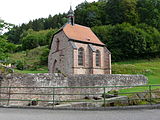
Source Church Schöllenbach (Evangelical Parish Church)
_Sch%C3%B6llenbach_Quellkirche.jpg)
_Sch%C3%B6llenbach_Quellkirche_Interieur_Altarfenster.jpg)

The spring church stands out among the sights and cultural monuments of Schöllenbach. The church in its recent form is a reduction building from the year 1782. The still existing walls of the choir of the once three-aisled church from 1465 (see above, history section) were separated by a new wall and designed into a new church building. The lost, presumably collapsed ceiling was replaced by a simple beam ceiling. The remaining remaining walls were removed and used as building material in other places in the county of Erbach. The size of the previous building, which is enormous for a small town like Schöllenbach and quite appropriate for a place of pilgrimage of supraregional importance, can still be guessed: today's portal to the churchyard corresponds to the former church portal and fragments of the Gothic buttresses on the inner walls indicate the original height of the building.
- Spring church Schöllenbach, exterior
Spring church with churchyard wall and church fountain

Portal lintel of the wall drawn in in 1782 to separate the choir

Roof turret with two bells

View over the churchyard and former church portal to the town hall of the Hesseneck community

Border stone with Kurmainzer wheel in front of the churchyard wall

_Sch%C3%B6llenbach_Quellkirche_Portalsturz_1782.jpg)
_Sch%C3%B6llenbach_Quellkirche_Turm.jpg)
_Sch%C3%B6llenbach_Quellkirche.jpg)
_Sch%C3%B6llenbach_Quellkirche_Grenzstein_Seite_Mainz.jpg)
The interior of the church dates mainly from the time of the first renovation in 1863/1865. These include the communion cupboard and the baptismal font, both of which are in neo-Gothic style, as well as the altarpiece of Adelheid Princess zu Hohenlohe-Ingelfingen from 1865, which was restored in 2004
- Spring Church Schöllenbach, interior

Interior with pulpit, altar, altarpiece, altar window and baptismal font

Organ, renewed in 1975
Fragment of the late Gothic buttress

Baptismal font from 1865

Altarpiece from 1865
_Sch%C3%B6llenbach_Quellkirche_Interieur.jpg)
_Sch%C3%B6llenbach_Quellkirche_Interieur_Orgel.jpg)
_Sch%C3%B6llenbach_Quellkirche_Interieur_Fragment.jpg)
_Sch%C3%B6llenbach_Quellkirche_Interieur_Taufstein.jpg)
_Sch%C3%B6llenbach_Quellkirche_Interieur_Altarbild.jpg)
Another renovation of the church took place in 1971/1972. Among other things, a previously walled up side entrance was exposed and the gallery was completely redesigned. In 1975 the organ was renewed.
The church fountain, the source that originally rose in the church, now comes to light on the churchyard wall. Even after the end of the pilgrimages, the spring was used by the population as a washing place and - until water pipes were installed in the village - also for drinking water supply. In 1922, during a major drought, the significantly higher and therefore drier neighboring village of Hesselbach was supplied with drinking water from the church fountain, which had to be carried uphill with barrels.
Other cultural monuments
In total, there are twelve registered cultural monuments in the district of Schöllenbach according to the Hessian Monument Protection Act .
| Dating | Hall | location | description | image |
| 18./19. century | Corridor 3, parcel 118/1 | Obere Siegfriedstrasse 31 | Former Gasthaus "Krone", formerly with a brewery, whose double cellar (around 1810/1822) still exists. The representative, two-storey house from the late 18th century consists of two half-timbered floors covered with a half-hipped roof over a massive, sandstone-colored plastered basement plinth. In front of it there is a renovated flight of stairs. In the yard of the property there is a sandstone sauerkraut stand from 1777. |
_Sch%C3%B6llenbach_Obere_Siegfriedstra%C3%9Fe_31.jpg)
|
| 1465 | Corridor 1, parcel 6/1 | Siegfriedstrasse / corner of Kirchbrunnenstrasse | Evangelical parish church / source church; see description above. |

|
| 19th century | Corridor 1, parcel 6/1 | Siegfriedstrasse / corner of Kirchbrunnenstrasse | Church fountain; see description above. |
_Sch%C3%B6llenbach_Kirchbrunnen.jpg)
|
| around 1800 | Corridor 2, parcel 33 | Lower Siegfriedstrasse 1 | Typical so-called Einhaus of the southern Odenwald. The living half of the single-storey house consists of clapboard half-timbering and has a basement. The economic half consists of massive red sandstone masonry. Apart from the younger access stairs to the living area and the roofing, the building is in its original state. Next to the house is a former pigsty with an oven. A small bridge with a breakwater as well as the remains of a valle stone enclosure to the neighboring courtyard round off the ensemble. |
_Sch%C3%B6llenbach_Untere_Siegfriedstra%C3%9Fe_1.jpg)
|
| 1842 | Corridor 1, parcel 1 | Lower Siegfriedstrasse 6 | Two-storey, partly clapboard half-timbered house in a dominant location in the center of the village. Originally the building was a bakery, later the schoolhouse of Schöllenbach. From 1971 to 2017 it was the town hall of the municipality of Hesseneck. |
_Sch%C3%B6llenbach_Untere_Siegfriedstra%C3%9Fe_6.jpg)
|
| 1768 | Corridor 2, parcel 52/2 | Lower Siegfriedstrasse 18 | Former "New Hammer House" of the "Schöllenbacher Hammer" (= hammer smithy ), built in 1768 by the hammer master Johann Ludwig Rexroth. The massive basement level made of red sandstone with stone cellar slides and the house sign in the portal lintel of the northern half of the house is visible. A second house sign with scissors, initials and the construction date was considered to have disappeared and only reappeared in 2014 in connection with renovation work. The upper floor consists of fully modern faced half-timbering. Extensive renovation measures in 2014. |
_Sch%C3%B6llenbach_Untere_Siegfriedstra%C3%9Fe_18.jpg)
|
| 1744 | Corridor 2, parcel 58/2 | Lower Siegfriedstrasse 18a | Former "cutting mill" of the "Schöllenbacher Hammers". One-storey, shingled half-timbered building over a basement floor made of solid red sandstone. A few years ago the single flight of stairs was still provided with an original wrought iron railing, which has since disappeared. The cellar entrance with the blacksmith's trade mark and the year 1744 in the apex is located under the outside staircase. Extensive renovation work in 2014. |
_Sch%C3%B6llenbach_Untere_Siegfriedstra%C3%9Fe_18a.jpg)
|
| 19th century | Corridor 2, parcel 56/2 | Lower Siegfriedstrasse 22 | Large round well with socket and cover plate made of sandstone, presumably belonging to the railwayman's house above to the south. A path between this house and the fountain can still be seen in the area. | |
| 19th century | Corridor 2, parcel 85/2 | Lower Siegfriedstrasse 24 | To the house at Siegfriedstr. 24 belonging, small footbridge over the Itterbach made of a single large sandstone slab. | |
| 1752 | at the Euterbach | State boundary stone in the form of a bearing stone. In addition to the year 1752, a cross, the Erbacher star and the Mainz wheel are carved. | ||
| Corridor 2, parcel 18/13 | Ecksgasse 10 | Short section of a row of positioning stones to enclose a cottage garden. | ||
| 20th century | Corridor 1, parcel 9 | Hesselbachweg | New cemetery on an artificially raised terrace east of the old churchyard. The terracing by means of dry stone walls between stream, meadow and forest led to an unusual and rare form of cemetery that was adapted to the landscape. |
|
Clubs and events
_Sch%C3%B6llenbach_Obere_Siegfriedstra%C3%9Fe_30_%2B_32.jpg)
Schöllenbach's club life is essentially shaped by the Schöllenbach volunteer fire brigade and the Schöllenbach choral society "Sängerkranz". The two clubs also organize most of the regular and irregular cultural events.
Economy and Infrastructure
economy
Schöllenbach does not have any business operations, and you will look in vain for shops or restaurants. The working population is essentially dependent on commuting in more distant places, and shopping for daily needs is associated with longer journeys. The fundamental suitability as a tourist destination for sustainable tourism due to the location and the wealth of natural and cultural resources is counteracted by the lack of infrastructure. Like many other Odenwald villages, Schöllenbach is one of the places that has suffered massively from population emigration, obsolescence and vacancies.
traffic

Schöllenbach is connected to the cities of Beerfelden and Eberbach via the 3108 state road leading through the Itterbachtal . On the L 3108 bus line 53 of the Odenwald-Regional-Gesellschaft (OREG) also runs between the two cities and serves several stops in Schöllenbach. Furthermore, there is a connection to the neighboring village of Hesselbach via a restricted road . This route is also used by a taxi service.
On the eastern edge of the village there is a stop on the Odenwaldbahn operated by VIAS , which runs from Eberbach station to Darmstadt or Hanau .
literature
- Wilhelm-Ludwig Federlin (Ed.): 1893 - 1993. 100 years of the Evangelical Church Congregation and Parish Schöllenbach-Bullau . Evangelical Church Council, Hesseck 1993.
- Dieter-Robert Pietschmann: “Church Castles”. A photo documentation of the Federal State of Baden-Württemberg and selected districts of the surrounding Federal States of Bavaria, Hessen, Rhineland-Palatinate and Thuringia (within the years 2006–2012) . Weinheim-Sulzbach, 2012.
- Hans Teubner, Sonja Bonin: Cultural monuments in Hessen. Odenwaldkreis . Vieweg, Wiesbaden 1998, ISBN 3-528-06242-8 , pp. 355-361.
- Search for Schöllenbach (Hessen) in the archive portal-D of the German Digital Library
- Literature on Schöllenbach in the Hessian Bibliography
Web links
- Schöllenbach. In: website. City of Oberzent
- Schöllenbach, Odenwaldkreis. Historical local dictionary for Hessen. In: Landesgeschichtliches Informationssystem Hessen (LAGIS).
Individual evidence
- ↑ a b c Schöllenbach, Odenwaldkreis. Historical local dictionary for Hessen. (As of October 16, 2018). In: Landesgeschichtliches Informationssystem Hessen (LAGIS).
- ↑ Numbers and dates. In: website. City of Oberzent, accessed March 2019 .
- ↑ Hesseneck - Schöllenbach District Website of the municipality of Hesseneck, accessed on October 12, 2013
- ↑ The excavators are rolling in Badisch-Schöllenbach ( Memento from October 14, 2013 in the Internet Archive ) In: Rhein-Neckar-Zeitung from August 14, 2013
- ↑ Description of the division situation on the official website of the municipality of Hesseneck.
- ↑ a b c d Wilhelm-Ludwig Federlin (Ed.): 1893 - 1993. 100 years of the Evangelical Church Community and Parish Schöllenbach-Bullau . Evangelical Church Council, Hesseck 1993.
- ↑ a b c d Without author: Guided tour of the source church in Schöllenbach . Without publisher, place and year. Available on site, in the church.
- ^ Georg Wilhelm Justin Wagner : Statistical-topographical-historical description of the Grand Duchy of Hesse . Volume 4. Leske, Darmstadt 1831, p. 88.
- ^ A b c Friedrich Mößinger: Mines and iron hammers in the Odenwald (= writings for local history and home care in the Starkenburger area. Issue 21/22, ZDB -ID 971701-8 ). Verlag der "Südhessische Post", Heppenheim 1957, p. 92.
- ^ Federal Statistical Office (ed.): Historical municipality directory for the Federal Republic of Germany. Name, border and key number changes in municipalities, counties and administrative districts from May 27, 1970 to December 31, 1982 . W. Kohlhammer GmbH, Stuttgart and Mainz 1983, ISBN 3-17-003263-1 , p. 358 .
- ↑ Section 81, Paragraph 1, Clauses 1 - 3 HGO.
- ↑ On the restoration of the altarpiece in the Neckar-Odenwald-Online-Magazin.
- ↑ Eberhard Rosewick: Hesselbach. Local history of a hill village in the rear Odenwald . Hesselbach, 1949, p. 78.
- ↑ a b c d e f g h i j k l m Monument database of the Hessian State Monuments Office (accessed on July 14, 2014)
- ^ A b c Hans Teubner, Sonja Bonin: Cultural monuments in Hessen. Odenwaldkreis . Vieweg, Braunschweig 1998, ISBN 3-528-06242-8 , pp. 355f.
- ^ Hans Teubner, Sonja Bonin: Cultural monuments in Hessen. Odenwaldkreis . Vieweg, Braunschweig 1998, ISBN 3-528-06242-8 , pp. 357f.
- ^ A b c Hans Teubner, Sonja Bonin: Cultural monuments in Hessen. Odenwaldkreis . Vieweg, Braunschweig 1998, ISBN 3-528-06242-8 , p. 359.
- ^ A b Hans Teubner, Sonja Bonin: Cultural monuments in Hessen. Odenwaldkreis . Vieweg, Braunschweig 1998, ISBN 3-528-06242-8 , pp. 359f.
- ^ Hans Teubner, Sonja Bonin: Cultural monuments in Hessen. Odenwaldkreis . Vieweg, Braunschweig 1998, ISBN 3-528-06242-8 , p. 360.
- ^ A b Hans Teubner, Sonja Bonin: Cultural monuments in Hessen. Odenwaldkreis . Vieweg, Braunschweig 1998, ISBN 3-528-06242-8 , p. 361.
- ↑ See register of associations (PDF; 11 kB) of the municipality of Hesseneck.
- ↑ See the event calendar of the community of Hesseneck.
Airlenbach | Beerfelden | Etzean | Hawk buttocks | Finkenbach | Gammelsbach | Lifting steel | Hesselbach | Hetzbach | Hinterbach | Kailbach | Kortelshütte | Ober-Hainbrunn | Ober-Sensbach | Olfen | Raubach | Rothenberg | Schöllenbach | Unter-Sensbach