Walkerszell
|
Walkerszell
Market Pleinfeld
Coordinates: 49 ° 5 ′ 55 ″ N , 10 ° 55 ′ 36 ″ E
|
|
|---|---|
| Height : | 410 m |
| Residents : | 68 |
| Postal code : | 91785 |
| Area code : | 09144 |
|
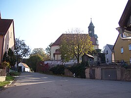
Walkerszell Church
|
|
Walkerszell is a district of the market Pleinfeld in the Middle Franconian district of Weißenburg-Gunzenhausen . The place has 66 inhabitants and is at an altitude of 410 meters above sea level. Walkerszell is about 5 kilometers west of Pleinfeld and 2 kilometers south of the Great Bromb axis . There are several rock cellars in the village . The place is traversed by the Walkerszeller Bach , a tributary of the Banzerbach .
history
Walkerszell was probably founded in the 10th century. The first documentary mention goes back to the year 1272. Originally the place belonged to the St. Emmeram Abbey in Spalt . Later he was sold to the Teutonic Order in Ellingen , whereby Walkerszell belonged to the Ballei Franken in the Franconian Empire . In ecclesiastical terms Walker cell belonged to a branch church to the parish church of St. Veit in the chapter (= deanery ) Hilpoltstein of high pin Eichstaett .
In 1824 Walkerszell had 96 inhabitants in 17 residential buildings. Since there were no building areas in the town, the size of the town remained constant for 150 years from the beginning of the 19th century, and the population grew only slowly. In 1950 Walkerszell had 124 inhabitants in 22 residential buildings. The population has been falling since the 1950s.
Saint John the Baptist
The Catholic branch church of St. Johann Baptist is a Teutonic Order church and was built in 1720 in place of a previous church that had burned down, from which the high altar dates from 1640. There is also a Lady Chapel , to which a procession takes place every year on the feast of the Assumption (August 15).
Web links
Individual evidence
- ↑ According to the contour image in BayernViewer ( memento of the original from April 8, 2015 in the Internet Archive ) Info: The archive link was inserted automatically and has not yet been checked. Please check the original and archive link according to the instructions and then remove this notice. interpolated.
- ↑ Historical Atlas of Bavaria , part of Franconia , vol. 8: Gunzenhausen - Weißenburg , edited by Hanns Hubert Hofmann. Commission for Bavarian State History , Munich 1960, p. 69.
- ↑ Historical Atlas of Bavaria , part of Franconia , vol. 8: Gunzenhausen - Weißenburg , edited by Hanns Hubert Hofmann. Commission for Bavarian State History, Munich 1960, p. 102.
- ↑ Historical Atlas of Bavaria , part of Franconia , vol. 8: Gunzenhausen - Weißenburg , edited by Hanns Hubert Hofmann. Commission for Bavarian State History, Munich 1960, p. 255.
- ^ Official directory of Bavaria , 1950 edition, there under the district of Weißenburg.
- ↑ Uwe Ritzer: ... and you're out! Milk is cheaper than ever - absurdly cheap. Farmer Lierheimer gives up . In: Süddeutsche Zeitung, May 21, 2016, pp. 13–15, here p. 15.

