Tinerhir (Province)


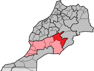
The approximately 13,500 km² large province of Tinghir ( Arabic إقليم تنغير; Central Atlas Tamazight ⵜⴰⵎⵏⴰⵜⵜ ⵏ ⵜⵉⵏⵉⵖⵉⵔ ) is located in the Moroccan region of Drâa-Tafilalet . The province was created in 2009 by decree No. 2-09-320 of June 11, 2009 from parts of the province of Ouarzazate (region of Souss-Massa-Drâa) and the province of Errachidia (region of Meknès-Tafilalet); until 2015 it belonged to the Souss-Massa-Draâ region . The capital of the province is the city of Tinghir (also spelled Tinerhir ).
geography
location
The province of Tinghir borders in the south with the province Zagora , in the west with the province Ouarzazate , in the north with the province Azilal , in the northeast with the province Midelt and in the east with the province Errachidia .
landscape
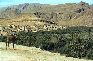
While the north of the province lies in the southern foothills of the High Atlas , which here still reaches heights of over 3000 m , the three largest cities El-Kelâa M'Gouna , Boumalne Dadès and Tinghir are located at altitudes of over 1000 m in the river oases of the Dadès valley (also called the road of the kasbahs ). To the south, the province is bounded by the Jbel Sarhro mountain range , the peaks of which reach heights between 2200 m and 2700 m . The most important rivers are the Oued Dades and the Oued Todra .
climate
According to the geographic situation, the climate is very different. In the small mountain villages of the High Atlas, summer daytime temperatures of up to 35 ° C are measured; in the valleys of the street of the kasbahs, d. H. in the three big cities it is not infrequently over 40 ° C. Only in the four winter months from November to February does some rain fall; sometimes snow, but it usually thaws within a few hours. Only in spring do the rivers carry enough water; in summer the river beds are usually dried up. While night temperatures often drop to around 10 to 15 ° C in summer, only around 5 ° C are measured in winter; light night frosts are also possible.
Population and history
More than 90% of the inhabitants of the province come from different Berber tribes . Up until the early 20th century there were only small and medium-sized villages in the entire region, the inhabitants of which lived to a large extent self-sufficient according to the traditional principles of self-sufficiency and were often at odds with one another. The mutual mistrust and mutual isolation were correspondingly high. It was only with the construction of a dirt road along the Dades that there was a little movement in the economic life and in the thinking of the Berber tribes living here during the French colonial era - it was only during this time that the first cities with an economic and social structure based on the division of labor emerged . The province of Tinghir was only created in 2009 by separating areas from the provinces of Ouarzazate and Errachidia.
Biggest places

Only the first three places are classified as urban settlements (M = commune municipal ); the rest are considered rural communities ( communes rurales ) with a large number of villages.
| local community | Residents | |
|---|---|---|
| 1994 | 2004 | |
| Tinghir (M) | 30,471 | 36,391 |
| El-Kelâa M'Gouna (M) | 10,524 | 14,190 |
| Boumalne Dadès (M) | 9,908 | 11,179 |
| Alnif | 19,023 | 20,175 |
| Ighil N'Oumgoun | 17,707 | 19,182 |
| Souk Lakhmis Dadès | 15,719 | 16,387 |
| Aït Sedrate Sahl El Gharbia | 12,211 | 14,864 |
| Taghzoute N'Ait Atta | 11,695 | 13,636 |
| Ait Youl | 3,972 | 4,466 |
economy
In the heights of the Atlas Mountains, livestock farming (sheep, goats) has been practiced since ancient times; It is also possible to grow barley. In the river oases along the Dades, characterized by date palms , there are also olive, pomegranate, nut and almond trees; In spring, vegetables ( potatoes , broad beans , carrots , tomatoes, etc.) are cultivated in their light shade . Cattle can only be kept to a limited extent and in stables in the river oases. Since many Berber families have migrated to the newly formed and ever larger cities since the 1970s because of reduced or no rainfall at all, life and the structure of employment have changed profoundly. Tourism has also become an important source of income for the people of the region.
Attractions
The street of the kasbahs with their former representative residential castles ( kasbahs ), which were mostly built at the beginning of the 20th century by tribal princes ( caids ) like El Glaoui , is one of the highlights of every trip to Morocco. To the north of Boumalne, at the end of the Dades Gorge , are the two villages of Aït Arbi and Aït Youl with their imposing residential castles ( tighremts ), which, however, are mostly subject to gradual decline.
Individual evidence
- ↑ Bulletin officiel of June 18, 2009 p. 1018,1020: List of the counties and municipalities of the Tinghir Province ( Memento of October 29, 2013 in the Internet Archive ), pages 56 and 58 of the PDF file 5.06 MB
