Toyoyama (Aichi)
| Toyoyama-chō 豊 山 町 |
||
|---|---|---|
|
|
||
| Geographical location in Japan | ||
| Region : | Chūbu | |
| Prefecture : | Aichi | |
| Coordinates : | 35 ° 15 ' N , 136 ° 55' E | |
| Basic data | ||
| Surface: | 6.19 km² | |
| Residents : | 15,647 (June 1, 2019) |
|
| Population density : | 2528 inhabitants per km² | |
| Community key : | 23342-1 | |
| Symbols | ||
| Flag / coat of arms: | ||
| Tree : | Shii castanopsis | |
| Flower : | Camellia sasanqua | |
| town hall | ||
| Address : |
Toyoyama Town Hall 260 , Aza Shin-Sakae, Ōaza Toyoba Toyoyama -chō, Nishikasugai-gun Aichi 480-0292 |
|
| Website URL: | www.town.toyoyama.lg.jp | |
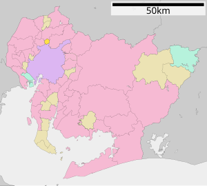
| Location of Toyoyamas in Aichi Prefecture | ||
Toyoyama ( Japanese 豊 山 町 , - chō ) is a Japanese community in Aichi Prefecture in Nishikasugai County . Toyoyama is located north of Nagoya. Nagoya Airport takes up about a third of the area .
geography
The municipality is traversed by the rivers Ōyama-gawa ( 大 山川 ) and Kutaraki-gawa ( 久 田 良 木 川 ).
Adjacent cities
- Nagoya (Kita Ward)
- Kasugai
- Komaki
- Kitanagoya
history
In 1906 the villages of Toyoba ( 豊 場 村 , - mura ) and Aoyama ( 青山 村 , -mura ) merge to form the village of Toyoyama. This received the status of a small town ( chō ) in 1972 .
On July 7, 2005, the small towns of Nishibiwajima , Kiyosu and Shinkawa merged to form the new city of Kiyosu . On March 20, 2006, the small towns of Shikatsu and Nishiharu merged to form the city of Kitanagoya . As a result, only the small towns of Kasuga and Toyoyama remained in Nishikasugai County . Since Kasuga was finally incorporated into the city of Kiyosu on October 1, 2009, Toyoyama is the only municipality in the district and the smallest municipality in Aichi Prefecture in terms of area.
education
There is a middle school and three elementary schools in the community.
sons and daughters of the town
- Ichirō Suzuki (* 1973), baseball player


