Ujjain (District)
| Ujjain District ( Hindi उज्जैन जिला ) |
|
|---|---|

|
|
| State | Madhya Pradesh |
| Division : | Ujjain |
| Administrative headquarters : | Ujjain |
| Area : | 6091 km² |
| Residents : | 1,986,597 (2011) |
| Population density : | 326 inhabitants / km² |
| Website : | Ujjain District |
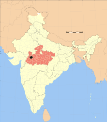
The district of Ujjain ( Hindi उज्जैन जिला ) is a district of the central Indian state of Madhya Pradesh . The administrative and economic center is the city of Ujjain , which has around 515,000 inhabitants and is also one of the seven holy cities of Hinduism .
geography
The district of Ujjain borders in the southwest on the district Dhar and in the northwest on the district Ratlam ; the district of Agar Malwa borders in the northeast, the district Shajapur in the east, the district Dewas in the southeast and the district Indore in the south .
The district of Ujjain is divided into seven administrative districts ( Tehsils or Subdivisions ): Badnagar, Ghatiya, Khacharod, Mahidpur, Nagda, Tarana and Ujjain with a total of around 1100 villages and - besides the city of Ujjain - only five medium-sized or smaller cities: Badnagar (approx 40,000), Khacharod (approx. 40,000), Mahidpur (approx. 40,000), Nagda (approx. 110,000) and Tarana (approx. 30,000).
The entire district is located in the west of the state of Madhya Pradesh on the Malwa Plateau , crossed by only a few smaller rivers, at an altitude of around 500 m. The annual rainfall amounts to approx. 900 mm / year, of which approx. 90% are accounted for by the summer monsoon months .
population

As a result of the sustained population growth in large parts of northern India, but also due to immigration from rural areas, the population of the district has increased enormously in the last few decades:
| year | 1991 | 2001 | 2011 |
| Residents | 1,383,086 | 1,710,982 | 1,986,864 |
Hindus dominate the rural villages (around 95%); about 15 to 20% of the urban population are Muslims . In the decade between 2001 and 2011, the population grew by a good 15% to around 1.98 million, with the male population only exceeding the female population by around 3%. About 60% of the population lives in rural villages; about a third of the people (mostly women) are illiterate. They speak Hindi and Malvi .
economy
The Ujjain district is characterized by agriculture to a very high degree, with migrant workers also playing a not unimportant role to this day. In the larger cities there are shops, handicraft businesses and small industries as well as banks, hospitals and secondary schools. Most of the villages are connected to the regional transport network by bus routes; there are several national railway lines.
history
The archaeological history of the Malwa Plateau goes back to the end of the Neolithic . In the Mahabharata epic, Ujjayani is mentioned repeatedly as the capital of the great and powerful Avanti kingdom. The Maurya emperor Ashoka (ruled 268–232 BC) is said to have resided here for a time. The region belonged from 4th to. 6th century to the Gupta empire ; then to the realm of the Rashtrakuta and the Paramara . In the 13th century the advance of Islam began in the region, which ended for the time being with the capture of Ujjain by Iltutmish (r. 1211-1236), the Sultan of Delhi , in 1234. After the Battle of Panipat in 1526, the Mughals took power over all of northern India, which they quickly lost after the death of Aurangzeb (1707) and had to cede it to the Marathas . The area had been under British control since 1818 . After India's independence (1947) and the territorial reform of 1956, the area came to the then newly created state of Madhya Pradesh .
Attractions
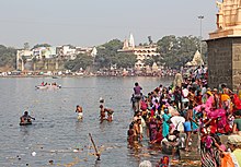
The fertile region around Ujjain is one of the origins and core areas of Hinduism ; however, medieval Hindu temples and sculptures are rather rare due to the destruction caused by Islam. The Mahakaleshwar Temple in the holy city of Ujjain is venerated as the seat of one of the 12 Jyotirlingas ; A Kumbh Mela festival takes place here every 12 years , in which other temples in the city are also included. In Ujjain there is also one of three preserved Jantar Mantar observatories of the Rajput prince and multiple governor of Malwa Jai Singh II.
Web links
Individual evidence
- ↑ Ujjain District - Map etc.
- ^ Ujjain District - Cities
- ^ Ujjain District - Villages
- ^ Ujjain District Map with elevation information
- ↑ Ujjain - Climate diagrams
- ↑ Ujjain District - Population 1991–2011
- ^ Ujjain District - Population
- ^ Ujjain District - Population
- ^ Ujjain District History
- ↑ Ujjain - Mahakaleshwar Temple
- ↑ Ujjain Temple
- ^ Ujjain - Jantar Mantar Observatory
Small text


