Valaská Belá
| Valaská Belá | ||
|---|---|---|
| coat of arms | map | |

|
|
|
| Basic data | ||
| State : | Slovakia | |
| Kraj : | Trenčiansky kraj | |
| Okres : | Prievidza | |
| Region : | Horná Nitra | |
| Area : | 64.774 km² | |
| Residents : | 2,079 (Dec. 31, 2019) | |
| Population density : | 32 inhabitants per km² | |
| Height : | 482 m nm | |
| Postal code : | 972 28 | |
| Telephone code : | 0 46 | |
| Geographic location : | 48 ° 53 ' N , 18 ° 24' E | |
| License plate : | PD | |
| Kód obce : | 514420 | |
| structure | ||
| Community type : | local community | |
| Structure of the municipality: | 6 parts of the community | |
| Administration (as of November 2018) | ||
| Mayor : | Miloš Cúcik | |
| Address: | Obecný úrad Valaská Belá 1 97228 Valaská Belá |
|
| Website: | www.valaskabela.sk | |
| Statistics information on statistics.sk | ||
Valaská Belá (until 1927 in Slovak "Valašská Belá"; in Hungarian Bélapataka - until 1900 Valaszkabella ) is a municipality in Slovakia .
The place was mentioned in writing for the first time in 1324 as Belafelde .
In addition to the actual place, the settlements Gápel (German Gapel ), Matušíková , Stanáková , Studenec and Škrípov belong to the municipality .
The place was founded in the Middle Ages under Wallachian law and at that time belonged to the rule of the Újfalussy family , from 1427 to the Bossányi rule , later to the Neutra diocese , the Rudnay family , the Splényi family and finally the Košeca castle in the 16th century . The inhabitants were employed in agriculture. The district of Gápel, which lies to the west of the main town, did not become part of the municipality until 1960 when it was separated from the municipality of Zliechov .
Attractions
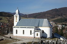
- Roman Catholic church in the classicist style from 1800

