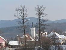
Nedožery-Brezany
| Nedožery-Brezany | ||
|---|---|---|
| coat of arms | map | |

|
|
|
| Basic data | ||
| State : | Slovakia | |
| Kraj : | Trenčiansky kraj | |
| Okres : | Prievidza | |
| Region : | Horná Nitra | |
| Area : | 24,164 km² | |
| Residents : | 2,141 (Dec. 31, 2019) | |
| Population density : | 89 inhabitants per km² | |
| Height : | 300 m nm | |
| Postal code : | 972 12 | |
| Telephone code : | 0 46 | |
| Geographic location : | 48 ° 49 ' N , 18 ° 39' E | |
| License plate : | PD | |
| Kód obce : | 514209 | |
| structure | ||
| Community type : | local community | |
| Structure of the municipality: | 2 parts of the community | |
| Administration (as of November 2018) | ||
| Mayor : | Jaroslav Pekár | |
| Address: | Obecný úrad Nedožery-Brezany Družstevná 367/1 972 12 Nedožery-Brezany |
|
| Website: | www.nedozery-brezany.sk | |
| Statistics information on statistics.sk | ||
Nedožery-Brezany is a double municipality in the west-center of Slovakia , with 2141 inhabitants (as of December 31, 2019). It belongs to the Okres Prievidza , a district of the higher administrative unit Trenčiansky kraj .
geography
Nedožery-Brezany is located in the Hornonitrianska kotlina basin (literally Oberneutraer basin) on the upper course of the Nitra River . The Žiar Mountains rise east of the village . The parish is about four kilometers from Prievidza .
Administratively, the municipality is divided into parts of Brezany and Nedožery.
history
Today's community was created in 1964 through the merger of previously independent places Brezany ( Berzseny in Hungarian ) and Nedožery (German Untermaut , Hungarian Nádasér ).
Nedožery was first mentioned in writing in 1264 and was the site of a toll station until the 19th century.
The first written mention of Brezany comes from 1267.

