
Forest Amorbach
|
Forest Amorbach
City of Breuberg
Coordinates: 49 ° 50 '55 " N , 9 ° 1' 34" E
|
|
|---|---|
| Height : | 203 (190-254) m above sea level NHN |
| Area : | 3.64 km² |
| Residents : | 510 (Jul 2, 2016) |
| Population density : | 140 inhabitants / km² |
| Incorporation : | 1st October 1971 |
| Postal code : | 64747 |
| Area code : | 06165 |

Wald-Amorbach is the smallest and oldest district of Breuberg in the Odenwaldkreis in Hesse .
location
Wald-Amorbach is surrounded by forest, in the red sandstone Odenwald and in the northern part of the Breuberg urban area. Landesstraße 3413 runs through the village. The village is grouped around the fork in the road Spessartstraße / Kirchstraße, where important traffic routes met early on.
history
The village was first mentioned in a document in 1286. On December 1, 1303, donations from the “Synandus miles de Bruberg” to the Höchst monastery , including Wald-Amorbach, are recorded. In 1381 two farms belong to the brothers Dieter and Peter von Amorbach. In 1391 the Höchst monastery held the tithe. Count Palatine Ruprecht II enfeoffed Dieter Gans von Otzberg and Count Palatine Ruprecht III in 1396 . 1408 Ulrich Bunner von Altheim with a farm, 20 acres of fields and two acres of meadows in Wald-Amorbach, which his father-in-law Peter Schelle von Amorbach gave to his daughter Anna as a Fuldisches fief. This fiefdom of the “Pfalzgräflichen Höfchen” expired in 1495. In 1567 the abbess of the Höchst Monastery in Wald-Amorbach sold to Balthasar Breunle zu Umstadt and the Königstein bailiff Philipp Freundt zu Breuberg.
In 1524, as part of the Umstadt condominium , the place belongs to Hessen and the Palatinate in equal parts . In 1803 the Palatinate share with the Otzberg office came to Hesse. In 1805 the town came into the possession of the Löwenstein-Wertheims through an exchange of territory from Hesse , but in 1806 it was returned to the now Grand Duchy of Hesse and there to the Habitzheim office. After the dissolution of the offices Wald-Amorbach came in 1822 for District District Erbach , who in 1848 at the government district Erbach opened. This was dissolved again in 1852 and Wald-Amorbach was added to the Neustadt district, in 1874 Wald-Amorbach was incorporated into the Erbach district. This was renamed the district of Erbach in 1938 and the Odenwaldkreis in 1972 .
On October 1, 1971, Wald-Amorbach was incorporated into the new town of Breuberg.
Local nobility


The place is named after the noble lords of Amorbach , also called Schelle von Amorbach , who owned fiefdoms and land in the area (Odenwald, along the Main to the Spessart ) and from their first documentary mention in 1286 until their extinction in the 16th century. Century saw the place as ancestral seat. They were probably vassals of the Fulda monastery , provided castle men at the nearby Breuberg castle and later also for the Hanau-Lichtenberg house on the Clingenburg (1481). The related Schelle von Umstadt also come from them. Their ancestral castle ( Waldamorbach Castle ) and probably also the neighboring Dorndiel Castle belonging to them are said to have been located next to the village .

Heraldic representations of the Amorbach bell
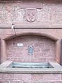
The village fountain in the center of the village with the coat of arms of the Amorbach bell


Historical forms of names
In historical documents, the place is documented under the following place names (the year it was mentioned in brackets): Amerbach (1286); Ammerbach (1303); Wüsten-Ammerbach (1391); üstammerbach (1398); Wusten Amerbach (1428); Amerbach (1457); Wosten Amorbach (1495); Wusten Amorbach (1567); If you knew Amorbach (1607); Amerbach (1608); Wüstamorbach (1829); Wald-Amorbach (1833).
Territorial history and administration
The following list gives an overview of the territories in which Wald-Amorbach was located and the administrative units to which it was subordinate:
- before 1390: Holy Roman Empire , Fulda Zent Umstadt Monastery ( condominium )
- 1390: Holy Roman Empire, the Palatinate (by purchase; to 1427 to rule Hanau pledged), centering Umstadt
- from 1524: Holy Roman Empire, Electoral Palatinate, Oberamt Otzberg
- from 1803: Holy Roman Empire, Landgraviate of Hessen-Darmstadt (by Reichsdeputationshauptschluss ), Oberamt Otzberg
- from 1805: Holy Roman Empire, Lords of Löwenstein-Wertheim (by exchange), Habitzheim office
- from 1806: Grand Duchy of Hesse , Principality of Starkenburg, Principality of Starkenburg, Habitzheim Office (lower jurisdiction continues at Löwenstein-Wertheim)
- 1815: German Bund , Grand Duchy of Hesse, Province Starkenburg , Office Habitzheim (for Standesherrschaft Loewenstein-Wertheim properly)
- from 1822: German Confederation, Grand Duchy of Hesse, Province of Starkenburg, District District Breuberg (separation between justice ( District Court Höchst ) and administration)
- from 1848: German Confederation, Grand Duchy of Hesse, Erbach district
- from 1852: German Confederation, Grand Duchy of Hesse, Starkenburg Province, Neustadt district
- from 1866: Grand Duchy of Hesse, Province of Starkenburg, Neustadt district
- from 1871: German Empire , Grand Duchy of Hesse, Starkenburg Province, Neustadt district
- from 1874: Grand Duchy of Hesse, Province of Starkenburg, District of Erbach
- from 1918: German Empire, People's State of Hesse , Starkenburg Province, Erbach district
- from 1938: German Empire, People's State of Hesse, Erbach district (In the course of the regional reform in 1938 , the three Hessian provinces of Starkenburg, Rheinhessen and Upper Hesse were dissolved.)
- from 1945: American zone of occupation , Greater Hesse , Darmstadt administrative district, Erbach district
- from 1949: Federal Republic of Germany , State of Hesse , Darmstadt district, Erbach district
- on October 1, 1971 to the new municipality of Breuberg
- from 1972: Federal Republic of Germany, State of Hesse, administrative district Darmstadt, Odenwaldkreis
Culture and sights
church
When Wald-Amorbach became part of the Electoral Palatinate in 1565, the inhabitants had to switch from the Lutheran confession to the Reformed. In 1577 they became Lutheran again with their Hessian affiliation, and in 1586 they had to switch from the Lutheran catechism to the reformed Heidelberg catechism.
Between 1739 and 1741, today's parish church was built as a new foundation, a previous church was mentioned as early as 1524, which was demolished due to dilapidation. The baroque hall church faces south. It ends with a polygonal closed choir . The church is crowned with a square roof turret with a slate octagonal Welsch hood . The simple plastered quarry stone building still has its original interior. A south pore was also built in 1850. Wald-Amorbach was first a branch of Groß-Umstadt, but now belongs to the parish of Breuberg. The church is dedicated to St. Bartholomew.
Nature and protected areas
Part of the nature reserve “ Bruchwiesen von Dorndiel ” lies in the district of Wald-Amorbach .
Individual evidence
- ↑ Commitment for a living village , article in the Darmstädter Echo of November 12, 2016; Retrieved November 29, 2017
- ↑ a b Wüstamorbach - a place in the Electoral Palatinate in the Breuberger Land , Breuberg city archive: Breuberg history and stories; Retrieved November 29, 2017
- ↑ Wald-Amorbach, Odenwaldkreis. Historical local dictionary for Hesse (as of May 19, 2017). In: Landesgeschichtliches Informationssystem Hessen (LAGIS). Hessian State Office for Historical Cultural Studies (HLGL), accessed on November 29, 2017 .
- ^ Federal Statistical Office (ed.): Historical municipality directory for the Federal Republic of Germany. Name, border and key number changes in municipalities, counties and administrative districts from May 27, 1970 to December 31, 1982 . W. Kohlhammer, Stuttgart / Mainz 1983, ISBN 3-17-003263-1 , p. 358 .
- ^ Entry on Wald-Amorbach in the scientific database " EBIDAT " of the European Castle Institute, accessed on September 14, 2016.
- ^ Archives for Hessian history and antiquity . Volume 6, p. 67 ff.
- ↑ a b Wald-Amorbach, Odenwaldkreis. Historical local dictionary for Hessen. (As of October 16, 2018). In: Landesgeschichtliches Informationssystem Hessen (LAGIS).
- ^ Letters of fief of the goose from Otzberg over two farms with all accessories in the village
- ^ Michael Rademacher: German administrative history from the unification of the empire in 1871 to the reunification in 1990. State of Hesse. (Online material for the dissertation, Osnabrück 2006).
- ^ Grand Ducal Central Office for State Statistics (ed.): Contributions to the statistics of the Grand Duchy of Hesse . tape 1 . Darmstadt 1866, p. 43 ff . ( online at Google Books ).
- ↑ Ordinance on the “Bruchwiesen von Dorndiel” nature reserve of November 26, 1990. (PDF) State Gazette for the State of Hesse 51/1990, p. 2738, No. 1222, accessed on July 15, 2020 .
Web links
- Local homepage
- The district on www.breuberg.de
- Wald-Amorbach, Odenwaldkreis. Historical local dictionary for Hessen. In: Landesgeschichtliches Informationssystem Hessen (LAGIS).

Hainstadt | Neustadt | Rai-Breitenbach with hamlet Mühlhausen | Sandbach | Forest Amorbach