
Vineyard (Aurach)
|
Vineyard
municipality Aurach
Coordinates: 49 ° 13 ′ 57 ″ N , 10 ° 21 ′ 50 ″ E
|
|
|---|---|
| Height : | 506 (487-515) m above sea level NHN |
| Residents : | 785 (May 25 1987) |
| Incorporation : | May 1, 1978 |
| Postal code : | 91589 |
| Area code : | 09804 |
Weinberg is a district of the municipality of Aurach in the district of Ansbach ( Middle Franconia ).
geography
The Wieseth rises in the parish village , to the north of it the Erlbach, which flows into the Wieseth at Leuckersdorf as a left tributary. Approx. 1 km north of the Roßkopf ( 520 m above sea level ) rises in the forest area Dienstfeld, about 0.75 km southwest of the Emmerspitz ( 524 m above sea level ). Approx. The Pfarrholz is located 0.5 km to the southwest.
The state road 1066 leading to front width Thann (3 km south) or to Aurach (4 km northeast). The district road AN 36 leads to Vehlberg (2 km west) or to Gindelbach (1.6 km south-east). The AN 3 leads to Atzenhofen (3 km north).
To the north of the place there has been a border point since the Carolingian times (mentioned in the Weinberger village regulations in 1433 and 1500), where the three districts of Sualafeldgau , Rangau and Maulachgau meet. This is also the border point where the three dioceses of Augsburg , Eichstätt and Bamberg (until 1817: Würzburg ) meet.
climate
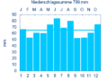
Diagram of precipitation averages Aurach for the period from 1961 to 1990


The average annual rainfall in Weinberg is 789 mm.
history
Weinberg originally belonged to the domain of Wahrberg Castle . On February 28, 1355, Erkinger von Wahrberg sold his property there with the associated tithe (24 properties, a bathhouse, a mill and an inn) and his share in the court at Weinberg to the Eichstätter Prince-Bishop Berthold von Zollern . In 1301 the chapel in honor of the apostles Peter and Paul in Weinberg is mentioned for the first time. Two boards in the entrance of the church provide information about the names of the pastors who have been active in Aurach since 1352. In 1358 the chapel became a parish church with a letter of indulgence, which was still in the church until 1601. In 1488 a brotherhood of St. Sebastian is confirmed in a document. This brotherhood has existed since that time and regularly celebrates its brotherhood festival on the Sunday after Sebastian. The Brotherhood Magistrate and staff attend the Brotherhood Service every first Thursday of the month.
Weinberg was in the Fraisch district of the Ansbach Oberamt Feuchtwangen . The land in Vineyard shared at the time the Bishopric of Eichstätt , the Monastery Sulz , the Canons Feuchtwangen and as its successor, the Margrave of Ansbach .
During the Thirty Years' War almost the entire village burned down (82 houses), the church and the rectory were looted. In the period that followed, the plague raged in the village.
Another devastating fire broke out in 1748, killing 39 buildings. In the same year the Scapular Brotherhood Seven Pains of Mary was founded, which belongs to the arch brotherhood of the Benedictine monastery in Oberelchingen near Ulm.
In 1732 the place consisted of 58 properties and 1 church (catholic), 1 rectory, 1 schoolhouse, 1 sheep house, 1 shepherd's house and a court consisting of 12 people. The village and community rulership was held by the Eichstättische Vogtamt Aurach . The landlords were feuchtwangische offices (11 properties; monastery administration office Sulz : 5 properties; Vogtamt Ampfrach : 1 economy with baking rights, 4 properties; parish Dorfgütingen: 1 economy with baking rights) and the Vogtamt Aurach: 3 economies with baking rights, 2 blacksmiths, 42 properties. At the end of the 18th century there were 62 households, 11 of which were Feuchtwangisch. From 1797 to 1808 the place was subordinate to the Justice and Chamber Office Feuchtwangen .
In 1806 Weinberg came to the Kingdom of Bavaria . With the community edict (early 19th century) the Weinberg tax district was formed, to which the towns of Angerhof , Birkach , Bittelhof , Charhof , Charmühle , Elbersroth , Elbleinsmühle , Gimpertshausen , Gindelbach , Gutenmühle , Leuckersdorf , Westheim and Windshofen belonged. A little later, the rural community of Weinberg was formed with Elbleinsmühle, Gindelbach, Gutenmühle, Vehlberg , Westheim and Windshofen . It was subject to the Feuchtwangen Regional Court in terms of administration and jurisdiction . The municipality had an area of 14,220 km². As part of the regional reform in Bavaria , this was incorporated into Aurach on May 1, 1978.
Architectural and ground monuments
- Bachgasse: processional chapel, small plastered niche with triangular gable, 18th century
- Feuchtwanger Straße 26: Processional chapel, plastered small building with gable roof, 18th century
- Near Röttenbacher Strasse: processional chapel, plastered saddle roof building with eaves profile, 18th century
- Kirchstrasse 1: Processional chapel, plastered niche with triangular gable, 18th century
- Kirchstraße 4: Catholic parish church of the Virgin Mary in Sorrows , formerly St. Aegidius (until 1975), medieval choir tower with pointed helmet, 14./15. Century, concrete nave modern (1975); with equipment; Remains of the former cemetery wall, in the core probably medieval. The large bell of the Weinberger Church was cast in Nuremberg in 1579 and bears the inscription "GOD'S WORD REMAINS ETERNAL - BELIEVE THAT YOU ARE BLESSED WITH DONE".
- Kr AN 3: Atonement cross made of sandstone, medieval.
- Hartfeld: Medieval sandstone cross; approx. 400 m outside the village towards Vehlberg.
- Close to the Wieseth spring: atonement cross made of sandstone, medieval.
- Vehlberger Wegfeld: Atonement cross made of sandstone, medieval.
- Village meadows; Westbergfeld: Former Ortsetter, four boundary stones from former 40, sandstone, 1537 and 1738.
- Various archaeological finds u. a. a hatchet from the La Tène period
Population development
Vineyard community
| year | 1818 | 1840 | 1852 | 1855 | 1861 | 1867 | 1871 | 1875 | 1880 | 1885 | 1890 | 1895 | 1900 | 1905 | 1910 | 1919 | 1925 | 1933 | 1939 | 1946 | 1950 | 1952 | 1961 | 1970 |
|---|---|---|---|---|---|---|---|---|---|---|---|---|---|---|---|---|---|---|---|---|---|---|---|---|
| Residents | 563 | 805 | 750 | 721 | 782 | 790 | 776 | 777 | 749 | 753 | 760 | 801 | 775 | 773 | 776 | 765 | 794 | 774 | 726 | 1111 | 1050 | 966 | 1000 | 1066 |
| Houses | 122 | 142 | 151 | 156 | 157 | 155 | 154 | 183 | ||||||||||||||||
| source |
Weinberg district
| year | 1818 | 1840 | 1861 | 1871 | 1885 | 1900 | 1925 | 1950 | 1961 | 1970 | 1987 |
|---|---|---|---|---|---|---|---|---|---|---|---|
| Residents | 300 | 426 | 439 | 426 | 414 | 423 | 450 | 614 | 623 | 703 | 785 |
| Houses | 71 | 85 | 87 | 89 | 88 | 87 | 112 | 217 | |||
| source |
religion
The place is predominantly Catholic and parish according to Mary's Seven Pains (vineyard).
Educational institutions
- Primary school (1st to 4th grade)
- Local library
literature
- Johann Kaspar Bundschuh : Vineyard . In: Geographical Statistical-Topographical Lexicon of Franconia . tape 6 : V-Z . Verlag der Stettinische Buchhandlung, Ulm 1804, DNB 790364328 , OCLC 833753116 , Sp. 129-130 ( digitized version ).
- Hans Karlmann Ramisch: District Feuchtwangen (= Bavarian art monuments . Volume 21 ). Deutscher Kunstverlag, Munich 1964, DNB 453909426 , p. 138-141 .
Web links
- Weinberg on the website aurach.de
- Weinberg in the location database of the Bayerische Landesbibliothek Online . Bavarian State Library
- Vineyard in the Topographia Franconiae of the University of Würzburg , accessed on September 16, 2019.
- Weinberg in the historical directory of the Association for Computer Genealogy
Individual evidence
- ↑ a b Bavarian State Office for Statistics and Data Processing (Ed.): Official local directory for Bavaria, territorial status: May 25, 1987 . Issue 450 of the articles on Bavaria's statistics. Munich November 1991, DNB 94240937X , p. 324 ( digitized version ).
- ↑ Vineyard in the Bavaria Atlas
- ↑ http://www.pfarrgemeinde-aurach.de/verzeichnis/visitenkarte.php?mandat=32402
- ↑ According to the Vetterische description of the Oberamt Feuchtwangen from 1732 ( see also Weinberg ( manor ) on the website geschichte-feuchtwangen.de).
- ^ Johann Bernhard Fischer : Vineyard . In: Statistical and topographical description of the Burggraftum Nürnberg, below the mountain, or the Principality of Brandenburg-Anspach. Second part. Containing the economic, statistical and moral condition of these countries according to the fifteen upper offices . Benedict Friedrich Haueisen, Ansbach 1790, p. 194 ( digitized version ).
- ↑ JK Bundschuh, Vol. 6, Col. 129f.
- ^ Address and statistical manual for the Rezatkreis in the Kingdom of Baiern . Buchdruckerei Chancellery, Ansbach 1820, p. 37 ( digitized version ).
- ↑ a b c Bavarian State Statistical Office (ed.): Official city directory for Bavaria, territorial status on October 1, 1964 with statistical information from the 1961 census . Issue 260 of the articles on Bavaria's statistics. Munich 1964, DNB 453660959 , Section II, Sp. 778 ( digitized version ).
- ^ Federal Statistical Office (ed.): Historical municipality directory for the Federal Republic of Germany. Name, border and key number changes in municipalities, counties and administrative districts from May 27, 1970 to December 31, 1982 . W. Kohlhammer, Stuttgart / Mainz 1983, ISBN 3-17-003263-1 , p. 707 .
- ↑ a b Only inhabited houses are given. In 1818 these were designated as fireplaces , in 1840 as houses , and from 1871 to 1987 as residential buildings.
- ↑ a b Alphabetical index of all the localities contained in the Rezatkreise according to its constitution by the newest organization: with indication of a. the tax districts, b. Judicial Districts, c. Rent offices in which they are located, then several other statistical notes . Ansbach 1818, p. 101 ( digitized version ). For the community of Weinberg plus the residents and buildings of Elbleinsmühle (p. 22), Gündelbach (p. 33), Guttenmühle (p. 34), Vehlberg (p. 97), Westheim (p. 102) and Windshofen (p. 104 ).
- ^ A b Eduard Vetter (Ed.): Statistical handbook and address book of Middle Franconia in the Kingdom of Bavaria . Self-published, Ansbach 1846, p. 114 ( digitized version ).
- ↑ a b c d e f g h i j k Bavarian State Statistical Office (Hrsg.): Historical municipality directory: The population of the municipalities of Bavaria from 1840 to 1952 (= contributions to Statistics Bavaria . Issue 192). Munich 1954, DNB 451478568 , p. 171 , urn : nbn: de: bvb: 12-bsb00066439-3 ( digitized ).
- ↑ a b Joseph Heyberger, Chr. Schmitt, v. Wachter: Topographical-statistical manual of the Kingdom of Bavaria with an alphabetical local dictionary . In: K. Bayer. Statistical Bureau (Ed.): Bavaria. Regional and folklore of the Kingdom of Bavaria . tape 5 . Literary and artistic establishment of the JG Cotta'schen Buchhandlung, Munich 1867, Sp. 1022 , urn : nbn: de: bvb: 12-bsb10374496-4 ( digitized version ).
- ↑ Kgl. Statistisches Bureau (Ed.): Directory of the municipalities of the Kingdom of Bavaria according to the status of the population in December 1867 . XXI. Issue of the contributions to the statistics of the Kingdom of Bavaria. Ackermann, Munich 1869, p. 160 ( digitized version ).
- ↑ a b Kgl. Statistical Bureau (ed.): Complete list of localities of the Kingdom of Bavaria. According to districts, administrative districts, court districts and municipalities, including parish, school and post office affiliation ... with an alphabetical general register containing the population according to the results of the census of December 1, 1875 . Adolf Ackermann, Munich 1877, 2nd section (population figures from 1871, cattle figures from 1873), Sp. 1188 , urn : nbn: de: bvb: 12-bsb00052489-4 ( digitized ).
- ↑ K. Bayer. Statistical Bureau (ed.): Community directory for the Kingdom of Bavaria. Manufactured due to the new organization of government districts, district offices and judicial districts. Addendum to issue 36 of the articles on Bavaria's statistics. Munich 1879, p. 63 ( digitized version ).
- ↑ K. Bayer. Statistical Bureau (ed.): Community directory for the Kingdom of Bavaria. Results of the census of December 1, 1880. Issue 35 of the articles on Bavaria's statistics. Munich 1882, p. 180 ( digitized version ).
- ↑ a b K. Bayer. Statistical Bureau (Ed.): Localities directory of the Kingdom of Bavaria. According to government districts, administrative districts, ... then with an alphabetical register of locations, including the property and the responsible administrative district for each location. LIV. Issue of the contributions to the statistics of the Kingdom of Bavaria. Munich 1888, Section III, Sp. 1118 ( digitized version ).
- ↑ a b K. Bayer. Statistical Bureau (Ed.): Directory of localities of the Kingdom of Bavaria, with alphabetical register of places . LXV. Issue of the contributions to the statistics of the Kingdom of Bavaria. Munich 1904, Section II, Sp. 1185-1186 ( digitized version ).
- ↑ a b Bavarian State Statistical Office (ed.): Localities directory for the Free State of Bavaria according to the census of June 16, 1925 and the territorial status of January 1, 1928 . Issue 109 of the articles on Bavaria's statistics. Munich 1928, Section II, Sp. 1224 ( digitized version ).
- ↑ a b Bavarian State Statistical Office (ed.): Official place directory for Bavaria - edited on the basis of the census of September 13, 1950 . Issue 169 of the articles on Bavaria's statistics. Munich 1952, DNB 453660975 , Section II, Sp. 1059 ( digitized version ).
- ↑ a b Bavarian State Statistical Office (Hrsg.): Official local directory for Bavaria . Issue 335 of the articles on Bavaria's statistics. Munich 1973, DNB 740801384 , p. 172 ( digitized version ).

Aurach | Wahrberg Castle | Dietenbronn | Eyerlohe | Gindelbach | Gutenmühle | Hazel mill | Hilsbach | Vehlberg | Vineyard | Westheim | Windshofen
Other places to live: Elbleinsmühle | Protection mill