
Elbersroth
|
Elbersroth
City of Herrieden
Coordinates: 49 ° 12 ′ 29 ″ N , 10 ° 25 ′ 5 ″ E
|
|
|---|---|
| Height : | 449 m above sea level NHN |
| Residents : | 226 (May 25 1987) |
| Incorporation : | July 1, 1971 |
| Postal code : | 91567 |
| Area code : | 09804 |
Elbersroth is a district of the city of Herrieden in the district of Ansbach in Middle Franconia ( Bavaria ).
geography
Geographical location
The parish village is located on the Wieseth and Charbach, which flows into the Wieseth as a right tributary. In the northeast is the Stadler Forest, in the east the Elbersrother Holz, approx. 1.5 km west of the village is the Kapellenwald, approx. 0.75 km south of the Gräbenwindner Holz. Approx. The Hirschberg rises 0.5 km to the southwest.
The district road AN 36 leads via Leuckersdorf to Windshofen (2.5 km west) or to Sickersdorf to the district road AN 37 (1.2 km south east). Communal roads lead to Aurach on state road 1066 (4 km north), to Stadel (2.7 km northeast), to Angerhof (0.3 km north) and to AN 37 at Träben winds (1 km southeast).
climate
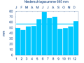
Diagram of precipitation mean values in Elbersroth for the period from 1961 to 1990


In Elbersroth, the average annual rainfall is 695 mm.
history
The place was first mentioned in 1288 in the will of Wolfram von Dornberg as "Elbigesrode". The place name means to slash a Elbig or Elbert , the founder of the settlement. Through the will, the bailiwick rights over the Eichstätter Oberland, to which Elbersroth also belonged, fell to the Counts of Oettingen . In 1316 there was a war between the Oettingern and Emperor Ludwig the Bavarian , which meant that they had to cede their bailiwick rights to the bishopric of Eichstätt . From the 15th century it was assigned to the Eichstätt Oberamt Wahrberg-Herrieden , which had all rights except for the High Court , as the place belonged to the Fraisch district of the Ansbach Oberamt Feuchtwangen . In 1732 there were 21 properties (2 courtyards, 4 half-yards, 1 half-yard with commercial and baking rights, 12 estates, 1 estate with a forge, 1 house), all of which were administered by the Aurach Vogtamt . There was also 1 Catholic church with a cemetery, 1 rectory, 1 schoolhouse and 1 shepherd's house. Nothing in these conditions changed until the end of the Old Kingdom . The number of properties was given as 22 in 1790. From 1797 to 1808 the place was subordinate to the Justice and Chamber Office Feuchtwangen .
In 1806 Elbersroth came to the Kingdom of Bavaria . With the community edict (early 19th century), the place was assigned to the Weinberg tax district . A little later the rural community of Elbersroth was formed, to which the places Angerhof , Birkach , Bittelhof , Gimpertshausen , Gräbenwinds , Leuckersdorf and Sickersdorf belonged. It was subject to the Feuchtwangen Regional Court in terms of administration and jurisdiction . The municipality had an area of 11,240 km². As part of the regional reform in Bavaria, this was incorporated into Herrieden on July 1, 1971.
Architectural monuments

- Near Pfarrer-Heumann-Straße: cemetery, complex around 1910; Cemetery house, small single-storey building with hipped roof, probably at the same time; with numerous matching grave monuments from the same period, mostly in the form of steles, Jechnerer tombstone, late 18th century; Enclosure, around 1910, with vase-shaped gate pillar crowns, late 18th century
- Near Pfarrer-Heumann-Straße: War memorial, Gothicized in the shape of a wayside shrine, 1914/18
- Pfarrer-Heumann-Straße 1: rectory; Residential house, two-storey building with hipped roof, early 18th century, later extended; Property wall, probably 18th century
- Pfarrer-Heumann-Straße 1–2: since April 1st, 1990 transitional facility of the AWO district association Roth-Schwabach with 16 places in the main building and 4 places in the rectory.
- Pfarrer-Heumann-Straße 5: Catholic parish church St. Jakob the Elder , hall church, new building by Carl Jäger , 1925, with neo-baroque elements, former choir from around 1750 included as a chapel, tower with onion dome; with equipment
- Pfarrer-Heumann-Straße 6 - massive farmhouse, interior extension, 1851; oven
- Pfarrer-Heumann-Straße 13: former granulator, single-storey massive gable roof, re. 1809; Outbuildings, barn, two-storey pitched roof buildings, partly half-timbered, probably early 19th century
- Weinberger Straße 7: Wegkapelle Herz Jesu, small massive saddle roof building, 1909; at the junction to Weinberg
- Near Wiesethstraße: Wegkapelle, small massive gable roof building, neo-Gothic, with Madonna figure, around 1850; on the road to Sickersdorf
- On the Wieseth: wayside cross, cast iron on sandstone plinth, second third of the 19th century; on the road to Leukersdorf
- Wayside cross: wooden crucifix, gilded, 19th century; on the old Herrieder Weg in the forest, 300 meters outside
Population development
Elbersroth community
| year | 1818 | 1840 | 1852 | 1855 | 1861 | 1867 | 1871 | 1875 | 1880 | 1885 | 1890 | 1895 | 1900 | 1905 | 1910 | 1919 | 1925 | 1933 | 1939 | 1946 | 1950 | 1952 | 1961 | 1970 |
|---|---|---|---|---|---|---|---|---|---|---|---|---|---|---|---|---|---|---|---|---|---|---|---|---|
| Residents | 356 | 496 | 456 | 429 | 461 | 510 | 517 | 510 | 526 | 516 | 536 | 535 | 550 | 590 | 597 | 592 | 559 | 534 | 502 | 798 | 733 | 677 | 561 | 532 |
| Houses | 64 | 78 | 94 | 99 | 99 | 108 | 117 | 122 | ||||||||||||||||
| source |
Elbersroth district
| year | 1818 | 1840 | 1861 | 1871 | 1885 | 1900 | 1925 | 1950 | 1961 | 1970 | 1987 |
|---|---|---|---|---|---|---|---|---|---|---|---|
| Residents | 110 | 206 | 181 | 211 | 207 | 199 | 218 | 293 | 228 | 215 | 226 |
| Houses | 24 | 33 | 41 | 41 | 47 | 51 | 51 | 69 | |||
| source |
religion
The place remained Catholic even after the Reformation. The inhabitants of the Roman Catholic denomination are parish according to St. Jakobus the Elder (Elbersroth) , the inhabitants of the Evangelical Lutheran denomination to the Christ Church (Herrieden) .
Sons of the place
- Ludwig Heumann (1869–1918), “herbal priest”, 1913 founder of the Heumann Arzneimittel company
- Gregor Maria Hanke (* 1954), Bishop of Eichstätt
literature
- Franz Abel: Elbersroth . In: Stadt Herrieden (ed.): Herrieden. City on the Altmühl . Fritz Majer & Sohn, Leutershausen 1982, ISBN 3-922175-08-2 , p. 263-275 .
- Johann Kaspar Bundschuh : Elbersroth . In: Geographical Statistical-Topographical Lexicon of Franconia . tape 2 : El-H . Verlag der Stettinische Buchhandlung, Ulm 1800, DNB 790364298 , OCLC 833753081 , Sp. 6 ( digitized version ).
- Hans Karlmann Ramisch: District Feuchtwangen (= Bavarian art monuments . Volume 21 ). Deutscher Kunstverlag, Munich 1964, DNB 453909426 , p. 34-36 .
Web links
- Elbersroth in the location database of the Bayerische Landesbibliothek Online . Bavarian State Library
- Elbersroth in the Topographia Franconiae of the University of Würzburg , accessed on September 16, 2019.
- Elbersroth in the historical directory of the association for computer genealogy
Individual evidence
- ↑ a b Bavarian State Office for Statistics and Data Processing (Ed.): Official local directory for Bavaria, territorial status: May 25, 1987 . Issue 450 of the articles on Bavaria's statistics. Munich November 1991, DNB 94240937X , p. 328 ( digitized version ).
- ↑ Elbersroth in the Bavaria Atlas
- ↑ F. Abel, p. 263 f.
- ↑ After the Vette Rischen description of Oberamt Feuchtwangen from 1732 (see Elbersroth (basic rule) on the website geschichte-feuchtwangen.de).
- ↑ Johann Bernhard Fischer : Elpersdorf Roth . In: Statistical and topographical description of the Burggraftum Nürnberg, below the mountain, or the Principality of Brandenburg-Anspach. Second part. Containing the economic, statistical and moral condition of these countries according to the fifteen upper offices . Benedict Friedrich Haueisen, Ansbach 1790, p. 185 ( digitized version ).
- ↑ JK Bundschuh, Volume 2, Col. 6.
- ^ Address and statistical manual for the Rezatkreis in the Kingdom of Baiern . Buchdruckerei Chancellery, Ansbach 1820, p. 35-36 ( digitized version ).
- ↑ a b c Bavarian State Statistical Office (ed.): Official city directory for Bavaria, territorial status on October 1, 1964 with statistical information from the 1961 census . Issue 260 of the articles on Bavaria's statistics. Munich 1964, DNB 453660959 , Section II, Sp. 775 ( digitized version ).
- ^ Wilhelm Volkert (ed.): Handbook of Bavarian offices, communities and courts 1799–1980 . CH Beck, Munich 1983, ISBN 3-406-09669-7 , p. 461 .
- ↑ a b Only inhabited houses are given. In 1818 these were designated as fireplaces , in 1840 as houses and from 1871 to 1987 as residential buildings.
- ↑ a b Alphabetical index of all the localities contained in the Rezatkreise according to its constitution by the newest organization: with indication of a. the tax districts, b. Judicial Districts, c. Rent offices in which they are located, then several other statistical notes . Ansbach 1818, p. 22 ( digitized version ). For the municipality of Elbersroth plus the residents and buildings of Angerhof (p. 5), Birkach (p. 10), Büttelhof (p. 14), Gimpertshausen (p. 30), Gräbenzüge (p. 31), Leuckersdorf (p. 54 ) and Sickersdorf (p. 86).
- ^ A b Eduard Vetter (Ed.): Statistical handbook and address book of Middle Franconia in the Kingdom of Bavaria . Self-published, Ansbach 1846, p. 109 ( digitized version ).
- ↑ a b c d e f g h i j k Bavarian State Statistical Office (Hrsg.): Historical municipality directory: The population of the municipalities of Bavaria from 1840 to 1952 (= contributions to Statistics Bavaria . Issue 192). Munich 1954, DNB 451478568 , p. 171 , urn : nbn: de: bvb: 12-bsb00066439-3 ( digitized ).
- ↑ a b Joseph Heyberger, Chr. Schmitt, v. Wachter: Topographical-statistical manual of the Kingdom of Bavaria with an alphabetical local dictionary . In: K. Bayer. Statistical Bureau (Ed.): Bavaria. Regional and folklore of the Kingdom of Bavaria . tape 5 . Literary and artistic establishment of the JG Cotta'schen Buchhandlung, Munich 1867, Sp. 1020 , urn : nbn: de: bvb: 12-bsb10374496-4 ( digitized version ).
- ↑ Kgl. Statistisches Bureau (Ed.): Directory of the municipalities of the Kingdom of Bavaria according to the status of the population in December 1867 . XXI. Issue of the contributions to the statistics of the Kingdom of Bavaria. Ackermann, Munich 1869, p. 160 ( digitized version ).
- ↑ a b Kgl. Statistical Bureau (ed.): Complete list of localities of the Kingdom of Bavaria. According to districts, administrative districts, court districts and municipalities, including parish, school and post office affiliation ... with an alphabetical general register containing the population according to the results of the census of December 1, 1875 . Adolf Ackermann, Munich 1877, 2nd section (population figures from 1871, cattle figures from 1873), Sp. 1184–1185 , urn : nbn: de: bvb: 12-bsb00052489-4 ( digitized version ).
- ↑ K. Bayer. Statistical Bureau (ed.): Community directory for the Kingdom of Bavaria. Manufactured due to the new organization of government districts, district offices and judicial districts. Addendum to issue 36 of the articles on Bavaria's statistics. Munich 1879, p. 63 ( digitized version ).
- ↑ K. Bayer. Statistical Bureau (ed.): Community directory for the Kingdom of Bavaria. Results of the census of December 1, 1880. Issue 35 of the articles on Bavaria's statistics. Munich 1882, p. 180 ( digitized version ).
- ↑ a b K. Bayer. Statistical Bureau (Ed.): Localities directory of the Kingdom of Bavaria. According to government districts, administrative districts, ... then with an alphabetical register of locations, including the property and the responsible administrative district for each location. LIV. Issue of the contributions to the statistics of the Kingdom of Bavaria. Munich 1888, Section III, Sp. 1116 ( digitized version ).
- ↑ a b K. Bayer. Statistical Bureau (Ed.): Directory of localities of the Kingdom of Bavaria, with alphabetical register of places . LXV. Issue of the contributions to the statistics of the Kingdom of Bavaria. Munich 1904, Section II, Sp. 1183 ( digitized version ).
- ↑ a b Bavarian State Statistical Office (ed.): Localities directory for the Free State of Bavaria according to the census of June 16, 1925 and the territorial status of January 1, 1928 . Issue 109 of the articles on Bavaria's statistics. Munich 1928, Section II, Sp. 1221 ( digitized version ).
- ↑ a b Bavarian State Statistical Office (ed.): Official place directory for Bavaria - edited on the basis of the census of September 13, 1950 . Issue 169 of the articles on Bavaria's statistics. Munich 1952, DNB 453660975 , Section II, Sp. 1055 ( digitized version ).
- ↑ a b Bavarian State Statistical Office (Hrsg.): Official local directory for Bavaria . Issue 335 of the articles on Bavaria's statistics. Munich 1973, DNB 740801384 , p. 170 ( digitized version ).
- ^ History of Heumann Pharma

Angerhof | Birkach | Bittelhof | Böckau | Brünst | Bushyard | Elbersroth | Esbach | Gimpertshausen | Trench winches | Herrieden | Heuberg | Höfstetten | Hohenberg | Lammelbach | Picket book | Leibelbach | Leuckersdorf | People book | Limbach | Manndorf | Mühlbruck | Neunstetten | Niederdombach | Oberschönbronn | Rauenzell | Regmannsdorf | Rös | Roth | Sauerbach | Schernberg | Schönau | Seebronn | Sickersdorf | Barn | Stegbruck | Steinbach | Velden | Winn
Other places to live: Altmühle | Ball mill | Rösmühle | Carpenter's mill