
Wettringhof
|
Wettringhof
City of Lüdenscheid
Coordinates: 51 ° 13 ′ 59 ″ N , 7 ° 40 ′ 58 ″ E
|
||
|---|---|---|
| Height : | 316 m | |
| Area : | 2.55 km² | |
| Residents : | 855 (2007) | |
| Population density : | 335 inhabitants / km² | |
| Postal code : | 58513 | |
| Area code : | 02351 | |
Location of Wettringhof in Lüdenscheid |
||
 Wettringhof
|
||

Wettringhof ( Sauerland Wettringhoe ) is the name of a district and belongs to the statistical district 07 (Wettringhof) of the district town of Lüdenscheid in western Sauerland , North Rhine-Westphalia . The district is located in a side valley of the Versetal and the statistical district is in the northeast of the urban area of Lüdenscheid. In the north, Wettringhof (855 inhabitants, as of 2007) borders on the neighboring community of Altena and in the east on the neighboring village of Augustenthal , which is also part of the city of Lüdenscheid and is in the direction of the city of Werdohl . Since 2010, the western district of Peddensiepen has also been included in the statistical district 07 (Wettringhof).
history

The federal road 229 runs through the district today, dividing it into a historical part and a new building area created in the second half of the 20th century.
South of the B 229 is the original historical part of the village Wettringhof, the old village, which consists of only about 10 houses. Most of the buildings in the village, which have now been renovated, can be dated in their core to the 15th century. In the 19th century, the village was expanded by the company Sichelschmidt, which still produces metal today.
Based on the basic structure in which the village is laid out, it can be assumed that the “Werdohler Chaussée”, now the Werdohler Landstrasse, was not always the main route between Werdohl and Lüdenscheid. Rather, it can be assumed that the main path once ran parallel to Werdohler Landstrasse, directly along the Schlittenbach. Historical maps prove this.
The "Schnurre" small railway of the Altenaer Eisenbahn district, known locally as the vernacular , also made a significant contribution to the development of the district. It connected the two industrial cities of Lüdenscheid and Werdohl through the Versetal and ensured that both people and goods could be transported more easily to Wettringhof.
To the north of the B 229 there are mainly many detached single-family and multi-family houses in the new development area. In recent years some of them have been renovated and vacant lots have been partially closed with new buildings. To this day, the atmosphere of the then newly created district is still quite calm and rural.
The Brunscheider Strasse, located further above Wettringhof, was a ravine that was expanded and paved by French prisoners of war during World War II and is therefore also known as the “Franzosenweg” by the locals. During the war years, French prisoners of war were often used as slave labor in agriculture.
Infrastructure
On the "Zum Timberg" street above Wettringhof, a large Lüdenscheid automotive supplier has taken over the property of the previous insolvent company that had been unused for a while and expanded it with a new high-bay warehouse. Before the development, there were various controversies about the construction of the camp, because the population feared negative effects on the Wettringhof district. After several constructive discussions, the construction of the camp could still be carried out. The other half of the area on the "Zum Timberg" street has not yet been built on and is still being offered by the Lüdenscheid city administration as a new commercial and industrial area.
In the center of the district there is also the municipal children's and youth club Wettringhof, which offers various activities.
Transport links
Rail transport
The closest train stations are Lüdenscheid and Werdohl stations . Both can be easily reached by car or bus in a few minutes.
Bus transport
The bus lines S2, 43, 61 and 243 (school bus line) of the Märkische Verkehrsgesellschaft (MVG) provide regular connections to the city center of Lüdenscheid and Werdohl as well as to the surrounding districts.
Important bus stops in the district are: “Gockeshohl”, “Industriegebiet Timberg”, “Brunscheid”, “Timbergstraße”, “Abzw. Wettringhof ”,“ Wettringhof ”,“ Am Flachsacker ”,“ Potmecker Weg ”and“ Am Waldberg ”.
Road traffic
The connection to the federal motorway network takes place via the nearby exits No. 14 Lüdenscheid and No. 15 Lüdenscheid-Süd of the A 45 . This leads north to Hagen and Dortmund and south to Siegen , Wetzlar , Gießen and Frankfurt am Main . Another alternative connection point is exit no. 13 Lüdenscheid-Nord of the A4 5. As already mentioned, the B 229 is also within Wettringhof. Parking spaces within Wettringhof ensure that drivers can park there.
Historical views

Alt-Wettringhof around 1935 from the perspective of the former Halbfas-Hof. In the background the house Werdohler Landstr. 232 (left) and 234 (right).

Alt-Wettringhof around 1935 from the view of the pasture on the northern slope of the Schlittenbach valley. To see: House Werdohler Landstr. 228 and horse stable d. House 230.

Alt-Wettringhof around 1935 from the perspective of the former Halbfas-Hof. In the background: House Werdohler Landstr. 232.

Alt-Wettringhof around 1935 from the southwest. Visible in the background: the southern slope on which Neu-Wettringhof is located today is still undeveloped.

Alt-Wettringhof around 1935 from the southwest. Visible in the background: the southern slope on which Neu-Wettringhof is located today is still undeveloped.
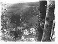
Alt-Wettringhof around 1930 from the south-southeast direction from the Brauck district down into the Schlittenbachtal. Visible in the background: the southern slope, which is still completely undeveloped and cultivated as a field.


Individual evidence
- ↑ Chapter 02 Population Statistical Yearbook of the City of Lüdenscheid The information in the infobox relates to the statistical district 07 (Wettringhof)
- ↑ Chapter 02 Population Statistical Yearbook of the City of Lüdenscheid The information in the infobox relates to the statistical district 07 (Wettringhof)
- ↑ Public information data on the development plan no. 14 of the city of Lüdenscheid - Wettringhof ( Memento of the original from May 6, 2016 in the Internet Archive ) Info: The archive link was automatically inserted and not yet checked. Please check the original and archive link according to the instructions and then remove this notice.
- ↑ Article from the Lüdenscheider Nachrichten of April 7th, 2011: "Industrial area" Zum Timberg "in Lüdenscheid"
- ↑ Information on the Wettringhof children's and youth club on the website of the city of Lüdenscheid

Augustenthal | Baukloh | Beer tree | Bridging | Bruges | Brüninghausen | Buckesfeld | Dickenberg | Thin board | Eggenscheid | Eichholz | Freisenberg | Gevelnorf | Grünewald | Hasley | Hellersen | High | Homert | Honsel | Downtown | Calve | Kluse | Almost | Leifringhausen | Upper frame | Oeneking | Othlinghausen | Piepersloh | Pöppelsheim | Ramsberg | Rathmecke | Sheep Bridge | Staberg | Stüttinghausen | Tinsberg | Trempershof | Vogelberg | Wefelshohl | Wehberg | Wettringhof | Worth