Złotoryja
| Złotoryja | ||
|---|---|---|

|
|
|
| Basic data | ||
| State : | Poland | |
| Voivodeship : | Lower Silesia | |
| Powiat : | Złotoryja | |
| Area : | 11.50 km² | |
| Geographic location : | 51 ° 8 ′ N , 15 ° 55 ′ E | |
| Height : | 276 m npm | |
| Residents : | 15,564 (Jun. 30, 2019) |
|
| Postal code : | 59-500 to 59-501 | |
| Telephone code : | (+48) 76 | |
| License plate : | DZL | |
| Economy and Transport | ||
| Next international airport : | Wroclaw | |
| Gmina | ||
| Gminatype: | Borough | |
| Surface: | 11.50 km² | |
| Residents: | 15,564 (Jun. 30, 2019) |
|
| Population density : | 1353 inhabitants / km² | |
| Community number ( GUS ): | 0226021 | |
| Administration (as of 2013) | ||
| Mayor : | Robert Pawłowski | |
| Address: | pl. Orląt Lwowskich 1 59-500 złotoryja |
|
| Website : | www.zlotoryja.pl | |
Złotoryja [ zwɔtɔˈrɨja ] ( German Goldberg i. Schlesien ) is a city in the Polish Voivodeship of Lower Silesia . It is the capital of the Powiat Złotoryjski and has about 16,000 inhabitants. The city belongs to the Euroregion Neisse .
Geographical location
The city is located in Lower Silesia on the right high bank of the Katzbach ( Kaczawa ) at the transition between the Silesian plain and the Sudetes , about 20 kilometers southwest of Legnica ( Liegnitz ). The Bober-Katzbach foothills extend to the south .
history
Goldberg is the oldest documented city foundation in Silesia under German law and received Magdeburg city charter in 1211 from Duke Heinrich I the Bearded from the Silesian line of the Piasts , who also became King of Poland in 1232. Gold was panned in the old river bed of the Katzbach (today Kaczawa ) as early as the 12th century . The city got its name from gold mining.
Around 1244 a monastery of the Franciscan order founded in 1210 was built in the city ; From 1274 it was the main monastery of Custody Goldberg in the Saxon Franciscan province ( Saxonia ). The convent was abolished between 1526 and 1530 as a result of the Reformation . In 1704 Bohemian Franciscans came to Goldberg, who had to give up their monastery in 1810 in the course of secularization .
Against the hegemonic claim of the reunified Poland, various piastic princes submitted to the feudal sovereignty of Bohemia, including the region around Goldberg in 1329. In 1348, the King and later Emperor Charles IV incorporated Silesia into the lands of the Bohemian Crown . Silesia became part of the Holy Roman Empire, initially under Luxembourg and from 1526 under Habsburg sovereignty. At that time Goldberg was an important city u. a. also for education, for example Albrecht von Wallenstein attended the Protestant Latin school that Friedrich II. von Liegnitz had founded and established by Valentin Friedland -Trozendorf. After the First Silesian War , Goldberg and Silesia left the Bohemian crown lands in 1742 and fell to Prussia .
Around 1900 Goldberg had a Protestant and a Catholic church, a Progymnasium , a district court, a number of different manufacturing plants, a brewery and fruit growing.
Until the end of the Second World War Goldberg belonged to the district Goldberg in the administrative district Liegnitz of the Prussian province Silesia of the German Empire .
Towards the end of World War II , Goldberg was captured by the Red Army in the spring of 1945 and soon afterwards, along with almost all of Silesia, was placed under Polish administration by the Soviet occupying power . The local German population, unless they had fled towards the end of the war, was subsequently expelled by the local Polish administrative authority .
Population development
| year | Residents | Remarks |
|---|---|---|
| 1890 | 6,437 | including 5,584 Evangelicals, 784 Catholics and 23 Jews |
| 1900 | 6,516 | mostly evangelicals |
| 1933 | 7,842 | |
| 1939 | 7,852 |
Culture and sights
The city has around 300 architectural monuments, including:
- Dolphin fountain
- former Franciscan monastery
- Holy Cross Church or St. Nicholas Church
- historic town houses on the Ring
- Church of the Nativity of Mary
- St. Hedwig Church
- town hall
- Column chapel
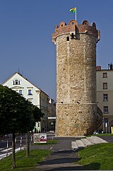
- Blacksmith's Bastion (Baszta Kowalska)
- City wall from the 14th century
The Gröditzburg is located in the immediate vicinity of the village .
Rural community
The rural community ( Gmina wiejska ) covers an area of 145 km² on which 7071 people lived on June 30, 2019. It belongs to the Euroregion Neisse . The town of Złotoryja does not belong to the rural municipality.
sons and daughters of the town
- Valentin Potsendorf (1490–1556), father of the Protestant school system, humanistic-Reformation school reformer, rector, preacher and author, shaped the schools in Goldberg. The Defiant Village Memorial commemorates his work.
- Fabian Timäus (1507–1581), Lutheran theologian
- Johann Daniel Hensel (1757–1839), pedagogue, writer and composer
- Konrad Engelbert Oelsner (1764–1828), publicist
- Johann Wilhelm Oelsner (1766–1848), Royal. Secret commercial councilor, industrialist, educator and philologist
- Robert von der Goltz (1811–1855), member of the Frankfurt National Assembly
- Waldemar Dyhrenfurth (1849–1899), public prosecutor, bizarre social critic, creator of Bonifazius Kiesewetter
- Friedrich Hoffmann (1875–1951), curator of the University of Königsberg
- Ernst Zinner (1886–1970), astronomer
- Ruth Kisch-Arndt (1898–1975), concert singer and university lecturer
- Wilhelm Gliese (1915–1993), astronomer
- Joachim Siol (* 1937), judge at the Federal Court of Justice
- Mariusz Szczygieł (* 1966), journalist
- Dariusz Suska (* 1968), poet
Twin cities
- Mimoň , Czech Republic
- Pulsnitz , Saxony
- Solingen , North Rhine-Westphalia
- Westerburg , Rhineland-Palatinate
literature
- Ludwig Sturm : History of the city of Goldberg in Silesia . Goldberg 1887.
- Ludwig Sturm : Valentin Potsendorf and the Latin School in Goldberg. Festschrift to celebrate the 400th birthday of Trotrzendorf, born on February 14, 1490 . Goldberg 1888.
- Hugo Weczerka (Hrsg.): Handbook of the historical places . Volume: Silesia (= Kröner's pocket edition . Volume 316). Kröner, Stuttgart 1977, ISBN 3-520-31601-3 , pp. 139-141.
- Hugo Weczerka, Heinz Stoob : City folder Goldberg - German city atlas . GSV Großchen City Atlas, Altenbeken 1987, ISBN 3-89115-004-0 .
Web links
- Homepage of the town of Złotoryja (Polish)
- Table sheet Goldberg 1937, 6,704 × 7,001 pixels (jpg, 12.2 MB)
- Memories of the teacher Thieles u. a. to Goldberg , according to Rector Heinrich Thiele in several editions of the Lübener Heimatblatt in 1971/72
Individual evidence
- ↑ a b population. Size and Structure by Territorial Division. As of June 30, 2019. Główny Urząd Statystyczny (GUS) (PDF files; 0.99 MiB), accessed December 24, 2019 .
- ↑ Dieter Berg (Ed.): Traces of Franciscan History. Chronological outline of the history of the Saxon Franciscan provinces from their beginnings to the present. Werl 1999, p. 43.67.265.397.451.
- ↑ a b Meyer's Large Conversation Lexicon . 6th edition, Volume 8, Leipzig / Vienna 1907, p. 93.
- ^ A b c Michael Rademacher: German administrative history from the unification of the empire in 1871 to the reunification in 1990. goldberg.html # ew39goldgoldbergs. (Online material for the dissertation, Osnabrück 2006).


