Zschopau (river)
| Zschopau | ||
|
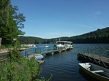
The river in the city of the same name, Zschopau |
||
| Data | ||
| Water code | EN : 5426 | |
| location | Saxony , Germany | |
| River system | Elbe | |
| Drain over | Freiberger Mulde → Mulde → Elbe → North Sea | |
| Headwaters | Am Fichtelberg 50 ° 26 ′ 13 ″ N , 12 ° 57 ′ 8 ″ E |
|
| Source height | approx. 1125 m above sea level NHN | |
| muzzle | at Döbeln in the Freiberg Mulde coordinates: 51 ° 7 '46 " N , 13 ° 3' 8" E 51 ° 7 '46 " N , 13 ° 3' 8" E |
|
| Mouth height | 155 m above sea level NHN | |
| Height difference | approx. 970 m | |
| Bottom slope | approx. 7.5 ‰ | |
| length | 130 km | |
| Catchment area | 1847 km² | |
| Discharge at the Kriebstein UP A Eo gauge : 1757 km² Location: 14.4 km above the mouth |
NNQ (09/28/1947) MNQ 1933/2005 MQ 1933/2005 Mq 1933/2005 MHQ 1933/2005 HHQ (08/13/2002) |
540 l / s 4.42 m³ / s 23.6 m³ / s 13.4 l / (s km²) 233 m³ / s 1350 m³ / s |
| Left tributaries | Geyerbach , Red Puddle , Greifenbach , Wilisch | |
| Right tributaries | Sehma , Pöhlbach , Preßnitz , Flöha | |
| Reservoirs flowed through | Kriebstein dam | |
The Zschopau (the origin of the name is not precisely documented, possibly Slavic Skapp ; rock , cliff or Sorb. Šučici ; die Rauschende, Tosende ) is a left, 130 km long tributary of the Freiberg Mulde in Saxony ( Germany ), which it with a Water flow of 23.8 m³ / s (compared to 10.3 m³ / s in the Freiberg Mulde above the mouth) more than tripled. The Zschopau drains a catchment area of 1847 km².
course

The Zschopau rises in the central Ore Mountains on the northern slope of the Fichtelberg at an altitude of 1,070 m and initially runs parallel to the Großer Mittweida in a northerly direction. The Zschopau forms the border between the Crottendorf forest district to the west and the Oberwiesenthal and Neudorf districts to the east . After leaving the forest area on the Fichtelberg, it passes the Waldhufendorf Crottendorf with the district Walthersdorf .
The Red Puddle flows into the town of Schlettau . It then flows through the towns of Tannenberg , Wiesa and Wiesenbad thermal baths . Then the Zschopau absorbs the water of the Pöhlbach . Shortly before Wolkenstein comes the water of the Preßnitz .
The cities of Wolkenstein, Zschopau , Flöha , Frankenberg / Sa are on their further course . and Mittweida . Between Scharfenstein and Zschopau, the largest left tributary, the Wilisch , flows into the river in the scattered settlement of Wilischthal .
The winding, increasingly narrow and rocky Zschopau valley is accompanied by the structurally interesting Annaberg-Buchholz and Bf-Flöha railway line .
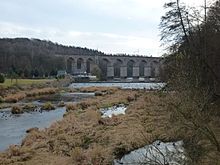
In Flöha, north of the Augustusburg hunting lodge that dominates the valley landscape, the largest tributary of the same name flows into it. The Flöha is even bigger than the Zschopau. In the Kriebstein dam in the gorge above the castle Kriebstein the Zschopau is jammed. It flows on through the town of Waldheim , where it is followed by the Chemnitz-Riesa railway line . The railway runs on the six km long section called bankruptcy mile to Limmritz over six viaducts. The valley is narrow and steep in places, so that the Zschopautal cycle path passes by at a suitable distance.
Finally, the river flows into the Freiberg Mulde near the village of Schweta, west of Döbeln .
Tributaries
- Greifenbach
- Geyerbach
- Sehma
- Pöhlbach
- Pressnitz
- Flea
- Wilisch
- Mortelbach , in Waldheim from the right
- Red puddle
Chain of castles
The importance of the river as a historical transport route, for example for wood, in a south-north direction and as a strategic obstacle between east and west, led to the construction of numerous castles in the Middle Ages, which are lined up like a chain along the water. Mule tracks mostly led along the ridges to avoid the river banks that were flooded at certain times of the year. At the river crossings ( fords , later with ferries and bridges, which often served as customs post and trading post at the same time) and at crossroads, castles, villages and monasteries developed. In the direction of the current from south to north these are:
- Wolkenstein Castle
- Scharfenstein Castle
- Wildeck Castle
- Schellenburg (replaced by the Augustusburg hunting lodge from 1567 )
- Lichtenwalde Castle
- Sachsenburg
- Zschöppichen Castle (replaced by Neusorge Castle in 1579 )
- Ringethal Castle
- Kriebstein Castle
- Waldheim Castle
After the confluence with the Freiberger Mulde , the chain continues in an east-west direction:
From the confluence with the Zwickauer Mulde , which is accompanied by a comparable chain of castles, the chain continues along the Mulde , now again in a south-north direction, to the confluence with the Elbe at Roßlau Castle .
literature
- Bruno Nestler: The Zschopau valley . 5 volumes. Graser, Annaberg 1903.
- The middle Zschopau area (= values of our homeland . Volume 28). 1st edition. Akademie Verlag, Berlin 1977.
Individual evidence
- ↑ Topographic map 1: 25,000
- ↑ Compilation of data from the University of Weimar ( Memento of the original from April 2, 2015 in the Internet Archive ) Info: The archive link has been inserted automatically and has not yet been checked. Please check the original and archive link according to the instructions and then remove this notice.
- ↑ Hydrological Handbook. (PDF; 637 kB) Part 3 - Main aquatic values. Free State of Saxony - State Office for Environment and Geology, p. 57 , accessed on December 25, 2017 .
- ↑ The mean estuary discharges are determined from the values of the Lichtenwalde (Zschopau) and indirectly Erlln , Nossen (Freiberg Mulde) and Niederstriegis 1 ( Striegis ) gauges . For the intermediate catchment area below Lichtenwalde, the area runoff was determined from the level data and multiplied by the area of the Zschopau catchment area below the Lichtenwalde level .


