Somogyfajsz: Difference between revisions
Content deleted Content added
No edit summary |
TerraCyprus (talk | contribs) m →top: clean up, replaced: | image → | image_skyline |
||
| (8 intermediate revisions by 6 users not shown) | |||
| Line 1: | Line 1: | ||
{{Infobox settlement <!--more fields are available for this Infobox--See Template:Infobox Settlement--> |
{{Infobox settlement <!--more fields are available for this Infobox--See Template:Infobox Settlement--> |
||
| official_name = Somogyfajsz |
| official_name = Somogyfajsz |
||
| other_name = {{lang|de|Füssen}} {{ |
| other_name = {{lang|de|Füssen}} {{in lang|de}} |
||
| settlement_type = Village |
| settlement_type = Village |
||
| |
| image_skyline = Szent Vendel-kápolna.jpg |
||
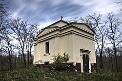
| image_caption = [[Saint Wendelin]] Chapel in Somogyfajsz |
| image_caption = [[Saint Wendelin]] Chapel in Somogyfajsz |
||
| image_shield = Somogyfajsz címere.jpg |
| image_shield = Somogyfajsz címere.jpg |
||
| Line 19: | Line 19: | ||
| subdivision_type3 = [[Districts of Hungary|District]] |
| subdivision_type3 = [[Districts of Hungary|District]] |
||
| subdivision_name3 = [[Kaposvár District|Kaposvár]] |
| subdivision_name3 = [[Kaposvár District|Kaposvár]] |
||
| subdivision_type4 = [[List of Catholic dioceses in Hungary|RC Diocese]] |
|||
| subdivision_name4 = [[Roman Catholic Diocese of Kaposvár|Kaposvár]] |
|||
| area_total_km2 = 18.26 |
| area_total_km2 = 18.26 |
||
| population_total = 546<ref>[http://www.ksh.hu/apps/hntr.telepules?p_lang=EN&p_id=18078 Somogyfajsz, KSH]</ref> |
| population_total = 546<ref>[http://www.ksh.hu/apps/hntr.telepules?p_lang=EN&p_id=18078 Somogyfajsz, KSH]</ref> |
||
| Line 26: | Line 28: | ||
| postal_code_type = [[Postal code]] |
| postal_code_type = [[Postal code]] |
||
| postal_code = 8708 |
| postal_code = 8708 |
||
| area_code = 85 |
| area_code = (+36) 85 |
||
| blank4_name_sec1 = [[NUTS statistical regions of Hungary|NUTS 3 code]] |
|||
| blank4_info_sec1 = HU232 |
|||
| blank5_name_sec2 = [[List of members of the National Assembly of Hungary (2018–22)|MP]] |
|||
| blank5_info_sec2 = [[József Attila Móring]] ([[KDNP]]) |
|||
| pushpin_map = Hungary |
| pushpin_map = Hungary |
||
| pushpin_label_position = <!-- the position of the pushpin label: left, right, top, bottom, none --> |
| pushpin_label_position = <!-- the position of the pushpin label: left, right, top, bottom, none --> |
||
| Line 32: | Line 38: | ||
| pushpin_mapsize = |
| pushpin_mapsize = |
||
| coordinates = {{coord|46.51028|17.57348|region:HU|display=inline,title}} |
| coordinates = {{coord|46.51028|17.57348|region:HU|display=inline,title}} |
||
| website = {{URL|http://www.somogyfajsz.hu|Somogyfajsz Online}} |
|||
}} |
}} |
||
'''Somogyfajsz''' is a village in [[Somogy County|Somogy]] county, [[Hungary]]. |
'''Somogyfajsz''' ({{lang-de|Füssen}}) is a village in [[Somogy County|Somogy]] county, [[Hungary]]. |
||
== External links == |
== External links == |
||
| Line 43: | Line 50: | ||
{{reflist}} |
{{reflist}} |
||
| ⚫ | |||
{{Kaposvár District}} |
{{Kaposvár District}} |
||
{{Somogy}} |
{{Somogy}} |
||
{{authority control}} |
|||
[[Category:Populated places in Somogy County]] |
[[Category:Populated places in Somogy County]] |
||
| ⚫ | |||
Latest revision as of 05:03, 6 October 2020
Somogyfajsz
Füssen (in German) | |
|---|---|
Village | |
 Saint Wendelin Chapel in Somogyfajsz | |
| Coordinates: 46°30′37″N 17°34′25″E / 46.51028°N 17.57348°E | |
| Country | |
| Region | Southern Transdanubia |
| County | Somogy |
| District | Kaposvár |
| RC Diocese | Kaposvár |
| Area | |
| • Total | 18.26 km2 (7.05 sq mi) |
| Population (2017) | |
| • Total | 546[1] |
| Demonym(s) | fajszi, somogyfajszi |
| Time zone | UTC+1 (CET) |
| • Summer (DST) | UTC+2 (CEST) |
| Postal code | 8708 |
| Area code | (+36) 85 |
| NUTS 3 code | HU232 |
| MP | József Attila Móring (KDNP) |
| Website | Somogyfajsz Online |
Somogyfajsz (German: Füssen) is a village in Somogy county, Hungary.
External links[edit]
References[edit]


