
Somogysárd: Difference between revisions
Content deleted Content added
change to svg coat of arm |
TerraCyprus (talk | contribs) m →top: clean up, replaced: | image → | image_skyline |
||
| Line 2: | Line 2: | ||
| official_name = Somogysárd |
| official_name = Somogysárd |
||
| settlement_type = Village |
| settlement_type = Village |
||
| |
| image_skyline = Somogysárd, Szent Rókus-kápolna.jpg |
||
| image_caption = [[Saint Roch]] Chapel with stone cross |
| image_caption = [[Saint Roch]] Chapel with stone cross |
||
| image_shield = HUN Somogysárd COA.svg |
| image_shield = HUN Somogysárd COA.svg |
||
Latest revision as of 05:04, 6 October 2020
Somogysárd | |
|---|---|
Village | |
 Saint Roch Chapel with stone cross | |
 Coat of arms | |
 Somogysárd Location of Somogysárd | |
| Coordinates: 46°24′49″N 17°35′49″E / 46.41364°N 17.59683°E | |
| Country | |
| Region | Southern Transdanubia |
| County | Somogy |
| District | Kaposvár |
| RC Diocese | Kaposvár |
| Area | |
| • Total | 36.36 km2 (14.04 sq mi) |
| Population (2017) | |
| • Total | 1,175[1] |
| Demonym(s) | sárdi, somogysárdi |
| Time zone | UTC+1 (CET) |
| • Summer (DST) | UTC+2 (CEST) |
| Postal code | 7435 |
| Area code | (+36) 82 |
| NUTS 3 code | HU232 |
| MP | József Attila Móring (KDNP) |
| Website | Somogysárd Online |
Somogysárd is a village in Somogy county, Hungary.
Gallery[edit]
-
 Holy Trinity Church in Somogysárd
 -
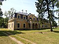 Somssich Mansion in Somogysárd
 -
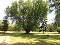 Park of the Somssich Mansion in Somogysárd
 -
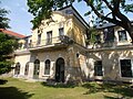 Somssich Mansion in Somogysárd


External links[edit]
References[edit]


This Somogy county location article is a stub. You can help Wikipedia by expanding it. |