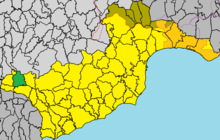
Agii Vavatsinias
|
Agii Vavatsinias Αγίοι Βαβατσινιάς |
||
|---|---|---|
|
|
||
| Basic data | ||
| State : |
|
|
| District : | Larnaka | |
| Geographic coordinates : | 34 ° 53 ' N , 33 ° 11' E | |
| Height above d. M .: |
714 m |
|
| Residents : | 131 (2011) | |
| LAU-1 code no .: | CY-03 | |
| Website: | www.agiivavatsinias.org/en | |
Agii Vavatsinias ( Greek Αγίοι Βαβατσινιάς ) is a place in the Larnaka district in Cyprus . At the last official census in 2011, the place had 131 inhabitants.
location
Agii Vavatsinias is located in the middle of the island of Cyprus at an altitude of 714 meters in the eastern Troodos Mountains .
The village is located about 35 km southwest of the capital Nicosia , 40 km west of Larnaka and 26 km northeast of Limassol . It can be reached via winding roads from the east, south and west.
The Nicosia District begins to the north and Limassol District to the west and south . Places in the area are Vavatsinia in the east, Ora in the south and Melini and Odou in the west.
Population development
| year | 1881 | 1911 | 1931 | 1960 | 1976 | 1982 | 2001 | 2011 | |
| Residents | 260 | 325 | 339 | 397 | 203 | 244 | 177 | 131 | |
| Source: 1881-2001 :, 2011: | |||||||||
Web links
Commons : Agioi Vavatsinias - collection of images, videos and audio files
Individual evidence
- ↑ a b Statistical Service. cystat.gov.cy, accessed March 24, 2019 . (Download)
- ↑ agiivavatsinias.org : History . Accessed March 24, 2019

