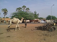
Banga Bana
|
Neighborhood Banga Bana |
|
|---|---|
| Coordinates | 13 ° 29 ′ N , 2 ° 6 ′ E |
| Basic data | |
| Country | Niger |
| Niamey | |
| Arrondissement | Niamey V |
| ISO 3166-2 | NE-8 |
| Residents | 24,700 (2012) |
Banga Bana (also: Bangabana ) is a district ( French : quartier ) in the Arrondissement Niamey V of the city of Niamey in Niger .
geography
The district is located on the southern edge of the urban area of Niamey V. Banga Bana is bordered to the north by National Road 6 and to the east by National Road 27 . The neighboring districts are Karadjé in the north, Pont Kennedy in the northeast, Kirkissoye in the southeast and Nordiré in the west. Banga Bana covers an area of approximately 208.2 hectares .
The district lies on an alluvial floor . The groundwater is at risk of being polluted. In the south and west, however, the groundwater level is so high that no infiltration is possible, which in turn increases the risk of flooding. There is a largely silted up temporary lake in Banga Bana.
The standard scheme for street names in Banga Bana is rue BB 1 , where the French rue for street is followed by BB for Banga Bana and finally a number. This goes back to a project to name streets in Niamey in 2002, in which the city was divided into 44 zones, each with its own letter abbreviations.
Banga Bana is considered one of the most dangerous areas of Niamey in terms of robbery and theft.
history
Banga Bana emerged as a settlement of the Zarma ethnic group in the 1980s, a decade of particularly rapid population growth in Niamey.
population
At the 2012 census, Banga Bana had 24,700 residents who lived in 4115 households. At the 2001 census, the population was 18,697 in 2,856 households, and at the 1988 census, the population was 5,266 in 975 households.

Infrastructure
There is a health center (Center de Santé Intégré) in Banga Bana , which in 2014 was responsible for caring for around 28,000 people. There are several primary schools in the neighborhood. The public primary school Ecole primaire de Banga Bana was founded in 1992.
literature
- Maman Rahaman: Crise du logement dans la ville de Niamey. Cas de quartier Banga Bana . Mémoire. Faculté des Lettres et Sciences Humaines, Université Abdou Moumouni de Niamey, Niamey 2012.
Web links
Individual evidence
- ^ The Study on Sanitation Improvement for the Niamey City in Republic of Niger. Appendix F: Existing Urban Conditions. (PDF) Japan International Cooperation Agency (JICA), August 2000, pp. F-1 and F-4 , accessed on April 19, 2019 .
- ↑ Hamadou Issaka, Dominique Badariotti: Les inondations à Niamey, enjeux autour d'un phenomène complexe . In: Cahiers d'Outre-Mer . No. 263 , September 2013, p. 384 ( journals.openedition.org [accessed April 21, 2019]).
- ↑ a b Dossou Modeste Landry: Report de stage rural au district sanitaire du Vème arrondissement de Niamey. Université Abdou Moumouni de Niamey, 2014, accessed on May 12, 2019 (French).
- ↑ Catherine Farvacque-Vitkovic, Lucien Godin, Hugues Leroux, Florence Verdet, Roberto Chavez: Street Addressing and the Management of Cities . World Bank, Washington, DC 2005, ISBN 0-8213-5815-4 , pp. 85 and 89 .
- ↑ Abdouramane Seydou: Délinquance et governance urbaine à Niamey. Institut de Recherche en Sciences Humaines, Université Abdou Moumouni de Niamey, July 27, 2018, accessed on April 19, 2019 (French).
- ↑ Abdourahmane Idrissa, Samuel Decalo: Historical Dictionary of Niger . 4th edition. Scarecrow, Plymouth 2012, ISBN 0-7864-0495-7 , pp. 336 .
- ↑ Apollinaire Tini: La gestion des déchets solid ménagers à Niamey au Niger: essai pour une stratégie de gestion durable . Thèse de doctorat. Institut National des Sciences Appliquées de Lyon, Lyon 2003, p. 46 ( theses.insa-lyon.fr [PDF; accessed May 1, 2019]).
- ↑ Répertoire National des localites (ReNaLoc). (RAR) Institut National de la Statistique de la République du Niger, July 2014, p. 718 , accessed on 7 August 2015 (French).
- ^ Répertoire National des Communes (RENACOM). (RAR) Institut National de la Statistique de la République du Niger, accessed on November 8, 2010 (French).
- ↑ Recensement Général de la Population 1988: Répertoire National des Villages du Niger . Bureau Central de Recensement, Ministère du Plan, République du Niger, Niamey March 1991, p. 226 ( web.archive.org [PDF; accessed May 4, 2019]).
- ↑ Issa Mamane Manirou: Etude diagnostique des conditions d'accès à l'eau, l'hygiène et l'assainissement dans les écoles publiques de l'arrondissement primaires communal V de la ville de Niamey, Niger . Mémoire de fin d'étude. Annexes. 2iE Institut International de l'Eau et de l'Environnement, Ouagadougou 2016, p. III ( documentation.2ie-edu.org [PDF; accessed June 3, 2019]).
- ↑ Daniel Barreteau, Ali Daouda: Systèmes éducatifs et multilinguisme au Niger. Results scolaires, double flux . Orstom / Université Abdou Moumouni de Niamey, Paris / Niamey 1997, ISBN 2-7099-1365-8 , p. 88 ( horizon.documentation.ird.fr [PDF; accessed May 29, 2019]).

